Indianapolis Stays Dry as Dry Air Holds Central Indiana Clear While Chicago, Evansville, and Louisville Deal With Active Radar on Indy 500 Race Morning
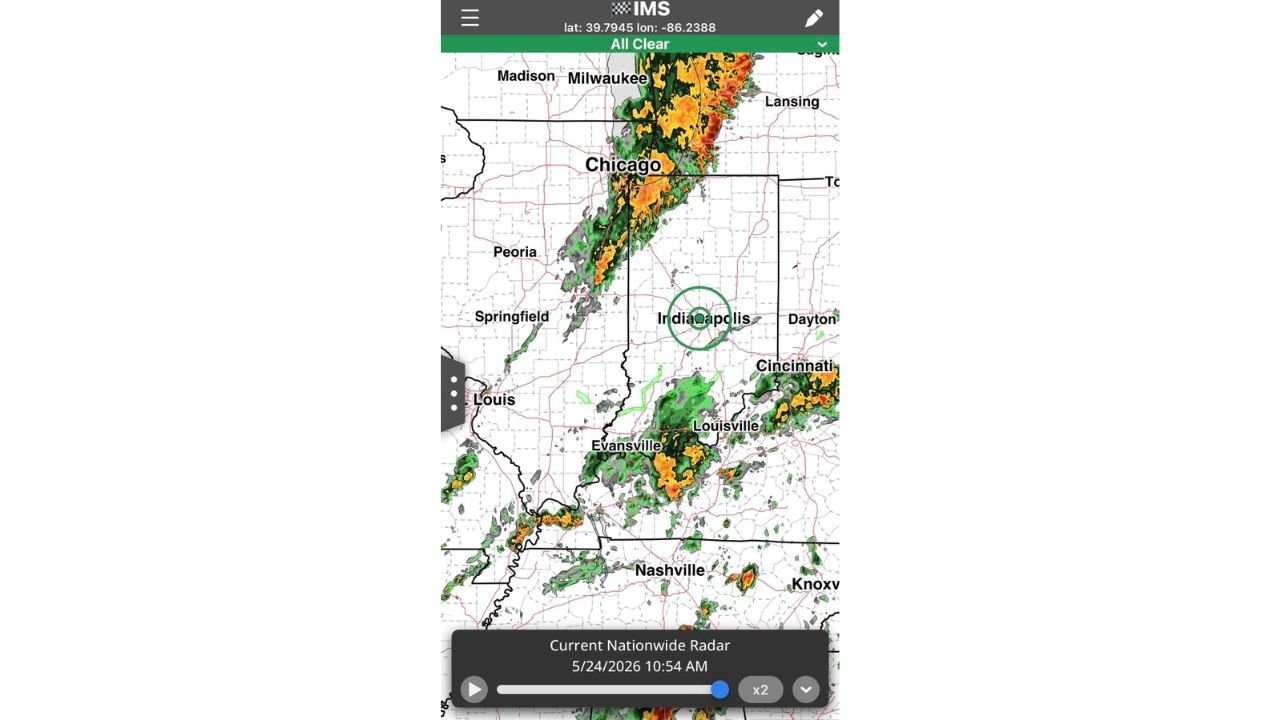
INDIANAPOLIS, INDIANA — Dry air is successfully keeping central Indiana clear as of 10:54 AM on Sunday May 24, 2026, holding Indianapolis in an all clear status while active storm activity presses from the north through Chicago and from the south through Evansville and Louisville on what is a critical morning for the Indianapolis 500.
What the Radar Is Showing Right Now
Live nationwide radar captured at 10:54 AM on May 24, 2026 tells a clear story of two active storm corridors bracketing a dry central Indiana.
Current radar conditions by area:
| Area | Current Condition |
|---|---|
| Indianapolis | All Clear, dry air holding |
| Chicago / Milwaukee corridor | Heavy active radar, orange and red returns |
| Evansville / Louisville | Active storm cells, moderate to heavy returns |
| Nashville area | Scattered activity |
| Dayton / Cincinnati | Light to moderate returns |
| Central Indiana | Dry, clear of precipitation |
The green circle on the radar is centered directly over Indianapolis, confirming the all clear status as of late morning.
Why Central Indianapolis Is Staying Dry
Dry air is working hard to keep the storm activity from both the north and south from merging over central Indiana. This dry air mass sitting over the Indianapolis metro is acting as a buffer, pushing moisture away from the core of the city while surrounding areas deal with active weather.
This is a temporary but meaningful window for the region.
Rain Risk Rises as the Day Progresses
The dry air holding central Indiana clear is not a permanent solution. Forecasters are tracking a rising rain risk through the afternoon hours.
Timeline of conditions:
- Now through late morning — Dry air holding, all clear over Indianapolis
- Late morning into early afternoon — Optimistic for an on time start, conditions manageable
- Afternoon hours — Rain risks begin to rise as storm lines push closer
- Not fully in the clear — Isolated chances cannot be ruled out as the day develops
What Surrounding Cities Are Dealing With
While Indianapolis holds dry, the contrast with neighboring cities is significant.
- Chicago and Milwaukee are under heavy active radar returns with orange and red reflectivity values indicating intense rainfall
- Evansville is dealing with active storm cells pushing through southern Indiana
- Louisville is seeing moderate to heavy returns on the southern end of the state
- Nashville has scattered activity further south
- Cincinnati and Dayton are tracking light to moderate returns to the east
The storm activity surrounding central Indiana on all sides makes the dry pocket over Indianapolis all the more notable and fragile.
The Afternoon Remains the Key Window to Watch
The dry air holding Indianapolis clear cannot be guaranteed to last through the entire afternoon. As the storm lines to the north and south continue tracking, the buffer protecting central Indiana will face increasing pressure.
Anyone with outdoor plans, events, or activities in the Indianapolis area should take advantage of the current dry window while monitoring conditions closely as the afternoon develops. The situation remains fluid and worth watching through the remainder of the day.
Stay with CabarrusWeekly.com for continuing updates on Indianapolis and central Indiana weather conditions through the Memorial Day weekend.