Texas Through the Tennessee Valley and Mid-Atlantic to Receive Up to 8 Inches of Drought-Busting Rain Over the Next 7 Days Through May 27 With Texas Facing the Heaviest Totals
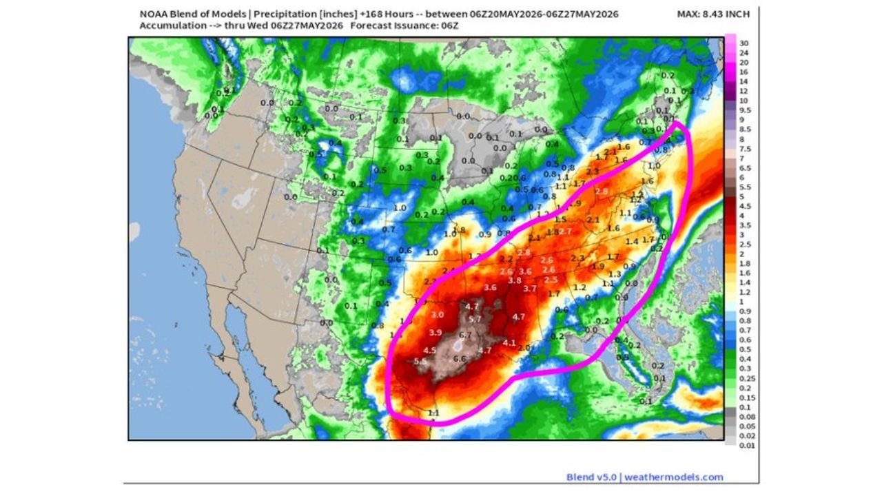
TEXAS, TENNESSEE VALLEY AND MID-ATLANTIC — A desperately needed and significant rainfall event is unfolding across a wide drought-stricken corridor stretching from Texas through the Tennessee Valley and into the Mid-Atlantic over the next 7 days through Wednesday, May 27, 2026. Forecast accumulation data shows a maximum of 8.43 inches possible in the heaviest areas, with Texas carrying the highest totals of the entire event. While much of this rain arrives during the holiday weekend, the relief it brings to large drought areas across the South, Tennessee Valley, and Mid-Atlantic is significant.
The Drought Context Makes This Rain Critically Important
The drought monitor map valid through May 12, 2026 shows the area from Texas through the Tennessee Valley and into the Mid-Atlantic locked in severe to exceptional drought conditions. Dark red zones of extreme and exceptional drought are spread across this entire corridor, with severe drought covering even broader surrounding areas. This incoming rainfall pattern over the next 7 days is one of the most meaningful precipitation events these drought-stricken regions have seen in a significant period of time.
Rainfall Totals Through May 27 by Region
| Area | Forecast Rainfall Total |
|---|---|
| South and Central Texas core | 5.80 to 8.43 inches |
| Broader Texas corridor | 3.60 to 6.70 inches |
| Tennessee Valley and Southeast | 2.60 to 3.80 inches |
| Mid-Atlantic corridor | 1.60 to 2.80 inches |
| Northeast fringe | 0.40 to 1.60 inches |
Texas Is Carrying the Heaviest Rain Totals
The most extreme rainfall over this 7-day stretch will fall across Texas, where the core of the precipitation event is forecast to produce up to 8.43 inches in isolated areas. Totals of 5 to 7 inches are widespread across a large portion of the state. While this level of rain is welcome relief for drought conditions, it also carries a significant flooding risk for communities across south and central Texas that will be absorbing these totals over a compressed timeframe.
The Tennessee Valley and South Will Also See Meaningful Relief
Across the Tennessee Valley and the broader South, rainfall totals of 2.5 to 3.8 inches are forecast through May 27. For areas sitting under severe to extreme drought, even 2 to 3 inches of well-distributed rainfall represents meaningful drought improvement across the region.
The Mid-Atlantic Drought Zone Gets Welcome Rain Too
The Mid-Atlantic corridor, which is also highlighted as a significant drought area on the current drought monitor, is forecast to receive 1.6 to 2.8 inches over the next 7 days. Combined with recent rainfall, this pushes the region toward measurable drought relief heading into the final days of May.
Holiday Weekend Plans Impacted Across the Region
A significant portion of this rainfall will arrive during the holiday weekend, impacting outdoor plans for millions across the drought corridor. Despite the timing, forecasters note the rain is necessary and beneficial for a region that has been dealing with persistent and worsening drought conditions.
Stay with CabarrusWeekly.com for daily rainfall and flood updates through May 27 across this multi-state weather pattern.