Multiple Rounds of Heavy Rain and Flooding Threat Lock In Over the Upper Midwest and Great Lakes for Three Straight Days as a Stationary Front Refuses to Move — Milwaukee, Detroit, and Green Bay Could See Over 4 Inches by Thursday
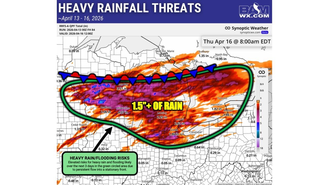
UPPER MIDWEST AND GREAT LAKES — A stationary front locked in place across the Upper Midwest and Great Lakes region is setting the stage for a serious and prolonged heavy rainfall event from April 13 through April 16, 2026. Multiple rounds of heavy rain are expected to ride along this boundary for three consecutive days, and the forecast totals are significant. Milwaukee is already projected at over 4 inches, Green Bay at 3.51 inches, and Detroit at 2.61 inches — with elevated flooding risks for the entire corridor sitting inside the primary threat zone.
A Stationary Front Is the Engine Behind This Event
The reason this rainfall threat is so serious is not just the amount of rain — it is the persistence of the setup. A stationary front anchored across the Upper Midwest and Great Lakes will act as a focus point for continuous moisture flow over the same areas for three straight days. When moisture-laden air persistently flows into a stationary boundary, it repeatedly forces precipitation over the same locations, stacking rainfall totals far beyond what a single storm system would produce.
The RRFS-A QPF total, run April 13, 2026 at 00Z and valid through April 16, 2026 at 12:00Z, captures the full three-day accumulation through Thursday April 16 at 8:00 AM EDT — and the numbers across the Great Lakes corridor are alarming.
Forecast Rainfall Totals by City — April 13 Through April 16
| City | 3-Day Forecast Rainfall Total |
|---|---|
| Milwaukee, Wisconsin | 4.07 inches |
| Green Bay, Wisconsin | 3.51 inches |
| Lansing, Michigan | 2.25 inches |
| Detroit, Michigan | 2.61 inches |
| Toledo, Ohio | 1.86 inches |
| Madison, Wisconsin | 2.06 inches |
| Hamilton, Ontario | 1.82 inches |
| Buffalo, New York | 1.86 inches |
| Sudbury, Ontario | 1.35 inches |
| North Bay, Ontario | 0.95 inches |
| Sault Ste. Marie | 0.72 inches |
| Cedar Rapids, Iowa | 1.31 inches |
| Duluth, Minnesota | 0.09 inches |
| Peoria, Illinois | 0.32 inches |
| Pittsburgh, Pennsylvania | 0.29 inches |
| Harrisburg, Pennsylvania | 0.21 inches |
| Cleveland, Ohio | 0.64 inches |
| Columbus, Ohio | 0.09 inches |
| Indianapolis, Indiana | 0.05 inches |
| Dayton, Ohio | 0.05 inches |
| Cincinnati, Ohio | 0.13 inches |
| St. Louis, Missouri | 0.48 inches |
| Washington D.C. | 0.13 inches |
| Baltimore, Maryland | 0.13 inches |
Milwaukee leads all cities at 4.07 inches — a three-day total that carries serious flooding implications, particularly if the heaviest rounds of rain fall in quick succession over already saturated ground. Green Bay at 3.51 inches and Detroit at 2.61 inches are also well inside the zone where flooding becomes a legitimate and elevated concern.
The 1.5 Inch Threshold Zone — Where Flooding Risk Is Highest
The heavy rainfall threat map highlights a specific zone where 1.5 inches or more of rain is forecast across the three-day period. This zone — circled in green on the forecast map — stretches from Wisconsin and northern Illinois eastward through Michigan, into northern Ohio, and across into western New York and southern Ontario.
Cities sitting inside or on the edge of this elevated flooding risk zone include:
- Milwaukee, Wisconsin — 4.07 inches
- Green Bay, Wisconsin — 3.51 inches
- Madison, Wisconsin — 2.06 inches
- Lansing, Michigan — 2.25 inches
- Detroit, Michigan — 2.61 inches
- Toledo, Ohio — 1.86 inches
- Buffalo, New York — 1.86 inches
- Hamilton, Ontario — 1.82 inches
The elevated flooding risk across this entire corridor is described as being driven by persistent flow into the stationary front — meaning the same mechanism that produces the first round of heavy rain on Monday will still be operating on Wednesday and into Thursday morning, repeatedly funneling heavy rain over the same areas.
Rain Totals Get Lighter the Further South You Go
Outside the primary 1.5-inch threat zone, rainfall totals drop off significantly as you move south through Illinois, Indiana, and Ohio. The further south you go, the more scattered and lighter the rainfall becomes. Cities like Indianapolis at 0.05 inches, Dayton at 0.05 inches, and Columbus at 0.09 inches sit well south of the primary threat corridor and will see only minimal rainfall from this event.
The sharp north-to-south gradient in rainfall totals reflects the positioning of the stationary front — areas closest to and north of the boundary get the heaviest and most repeated rainfall, while areas well to the south remain largely dry or see only light, scattered precipitation.
Flooding Risk Is Elevated — Three Days of Repeated Heavy Rain
The flooding concern with this event is straightforward and serious. Three consecutive days of heavy rain over the same corridor, driven by persistent flow into a stationary front, creates the conditions for:
- Urban and street flooding across Milwaukee, Green Bay, Detroit, and surrounding cities as drainage systems are overwhelmed by repeated heavy rainfall
- River and stream flooding as waterways respond to sustained multi-day rainfall inputs across the watershed
- Flash flooding potential during the heaviest individual rain rounds, particularly in areas where rainfall rates are highest
The stationary front is not expected to shift significantly through Thursday morning, meaning there is no natural mechanism to interrupt the repeated rainfall rounds over the same areas for the duration of the event.
Three-Day Heavy Rain Threat at a Glance
| Factor | Details |
|---|---|
| Event timeframe | April 13 through April 16, 2026 |
| Valid through | Thursday April 16 at 8:00 AM EDT |
| Rainfall mechanism | Stationary front with persistent moisture flow |
| Highest total | Milwaukee — 4.07 inches |
| Primary threat zone | Wisconsin through Michigan into northern Ohio and western New York |
| 1.5 inch threshold zone | Green circled area from Wisconsin east through Michigan and into New York |
| Flooding risk | Elevated across the entire primary threat corridor |
| Southern areas | Scattered and lighter — totals mostly under 0.5 inches |
Milwaukee, Green Bay, and Detroit Are in the Bullseye
Three days. One stationary front. Multiple rounds of heavy rain hitting the same cities repeatedly. Milwaukee at over 4 inches, Green Bay at 3.51, Detroit at 2.61, Toledo and Buffalo both approaching 1.86 — the numbers across the Upper Midwest and Great Lakes corridor from April 13 through April 16 represent a significant and prolonged flooding threat that residents, emergency managers, and drivers across the region need to take seriously well in advance.
Do not underestimate a multi-day stationary front rainfall event. The slow and persistent nature of this setup is precisely what makes it dangerous — the rain does not come all at once and leave. It comes in rounds, over and over, until the totals add up to levels the ground and drainage systems cannot handle.
Stay with CabarrusWeekly.com for ongoing heavy rain and flooding coverage across the Upper Midwest and Great Lakes, daily rainfall total updates, and any flood watches and warnings issued across the Milwaukee, Green Bay, Detroit, and surrounding corridor through Thursday April 16.