Eastern Texas Through the Ohio Valley Faces Flooding Threat as 3 Inches or More of Rain Targets Houston San Antonio Jackson Cincinnati Nashville and Pittsburgh Through May 29
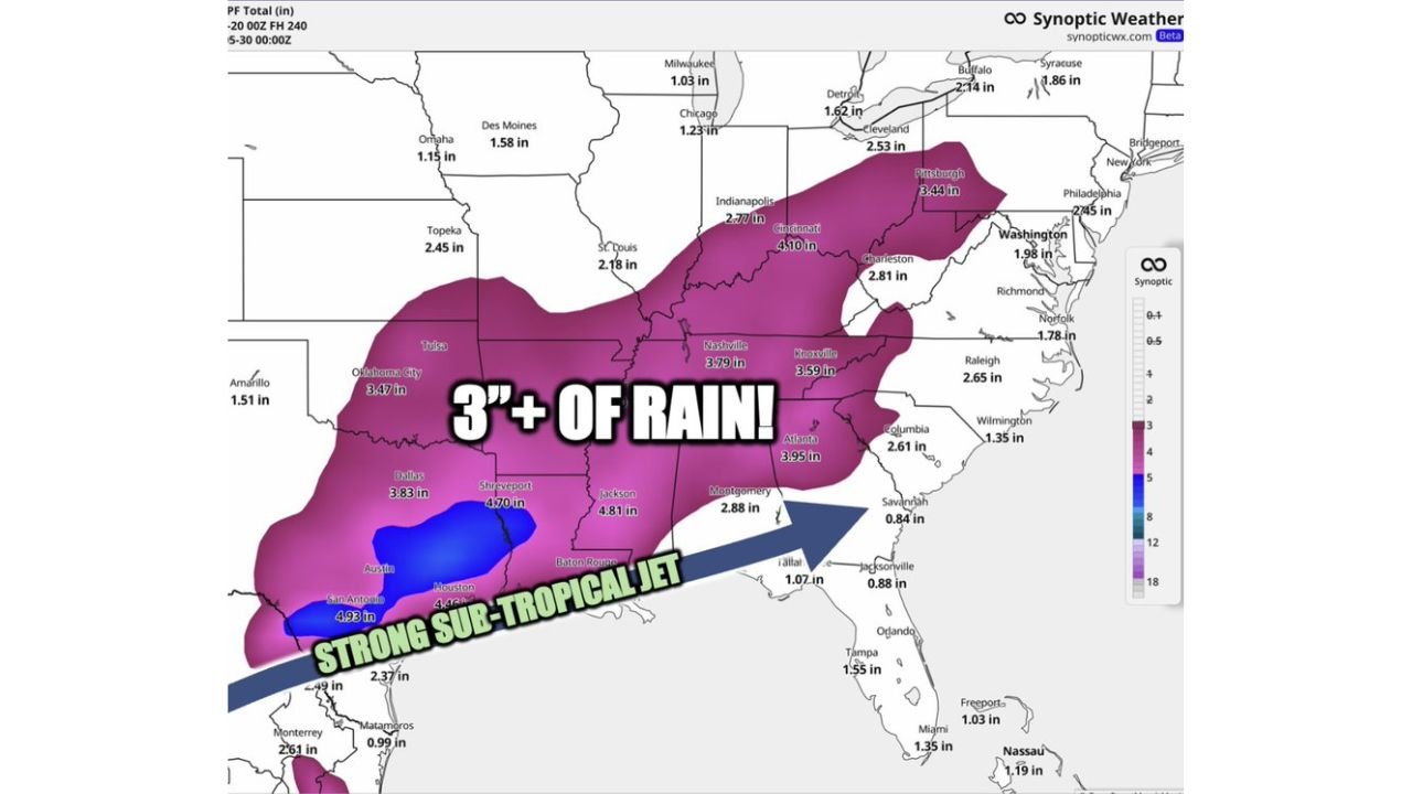
UNITED STATES — A 10-day excessive rain event is unfolding across a massive corridor stretching from eastern Texas through the Ohio Valley, with forecast rainfall totals from May 20 through May 29, 2026 showing 3 inches or more across dozens of major cities. A strong sub-tropical jet is driving relentless moisture into the region, and forecasters are raising increasing concerns about flooding throughout this period.
What Is Fueling This 10-Day Wet Pattern
A strong sub-tropical jet stream is funneling an extraordinary amount of Gulf moisture northward and eastward across the country. This persistent atmospheric setup will keep rounds of heavy rain returning to the same areas repeatedly over the next 10 days, making cumulative flooding the primary danger rather than any single storm event. Ground saturation will worsen with each additional round of rainfall.
City by City Rainfall Forecast Through May 29
| City | Forecast Rainfall Total |
|---|---|
| San Antonio, Texas | 4.93 inches |
| Jackson, Mississippi | 4.81 inches |
| Houston, Texas | 4.46 inches |
| Shreveport, Louisiana | 4.70 inches |
| Cincinnati, Ohio | 4.10 inches |
| Atlanta, Georgia | 3.95 inches |
| Nashville, Tennessee | 3.79 inches |
| Dallas, Texas | 3.83 inches |
| Pittsburgh, Pennsylvania | 3.44 inches |
| Oklahoma City, Oklahoma | 3.47 inches |
| Knoxville, Tennessee | 3.59 inches |
| Charleston, West Virginia | 2.81 inches |
| Montgomery, Alabama | 2.88 inches |
| Cleveland, Ohio | 2.53 inches |
| Indianapolis, Indiana | 2.77 inches |
| Raleigh, North Carolina | 2.65 inches |
| Topeka, Kansas | 2.45 inches |
| Philadelphia, Pennsylvania | 2.45 inches |
| Buffalo, New York | 2.14 inches |
| St. Louis, Missouri | 2.18 inches |
| Washington D.C. | 1.98 inches |
| Norfolk, Virginia | 1.78 inches |
| Detroit, Michigan | 1.62 inches |
| Des Moines, Iowa | 1.58 inches |
| Tampa, Florida | 1.55 inches |
The Core Flooding Zone From Texas to the Ohio Valley
The areas carrying the greatest flood risk over this 10-day window are the cities sitting inside the 3 inch or greater rainfall zone. This zone stretches from San Antonio and Houston in south Texas northeastward through Shreveport, Jackson, Dallas, Oklahoma City, Nashville, Cincinnati, Pittsburgh, and Atlanta. These communities will be absorbing repeated rounds of heavy rainfall with little recovery time between events.
Very Active Weather Pattern Through the End of May
This is not a brief wet stretch. The pattern described by forecasters as very, very active is expected to persist straight through May 29. Rivers and streams across the eastern Texas to Ohio Valley corridor that are already running high from recent rainfall events are at elevated risk of rising further and overflowing their banks as additional inches accumulate.
Stay with CabarrusWeekly.com for daily flood and rainfall updates through this dangerous 10-day weather pattern.