West Texas Supercells Threatening Very Large Hail and Tornadoes While Damaging Winds Target Ohio Indiana Kentucky Pennsylvania Virginia and Maryland on Wednesday May 20
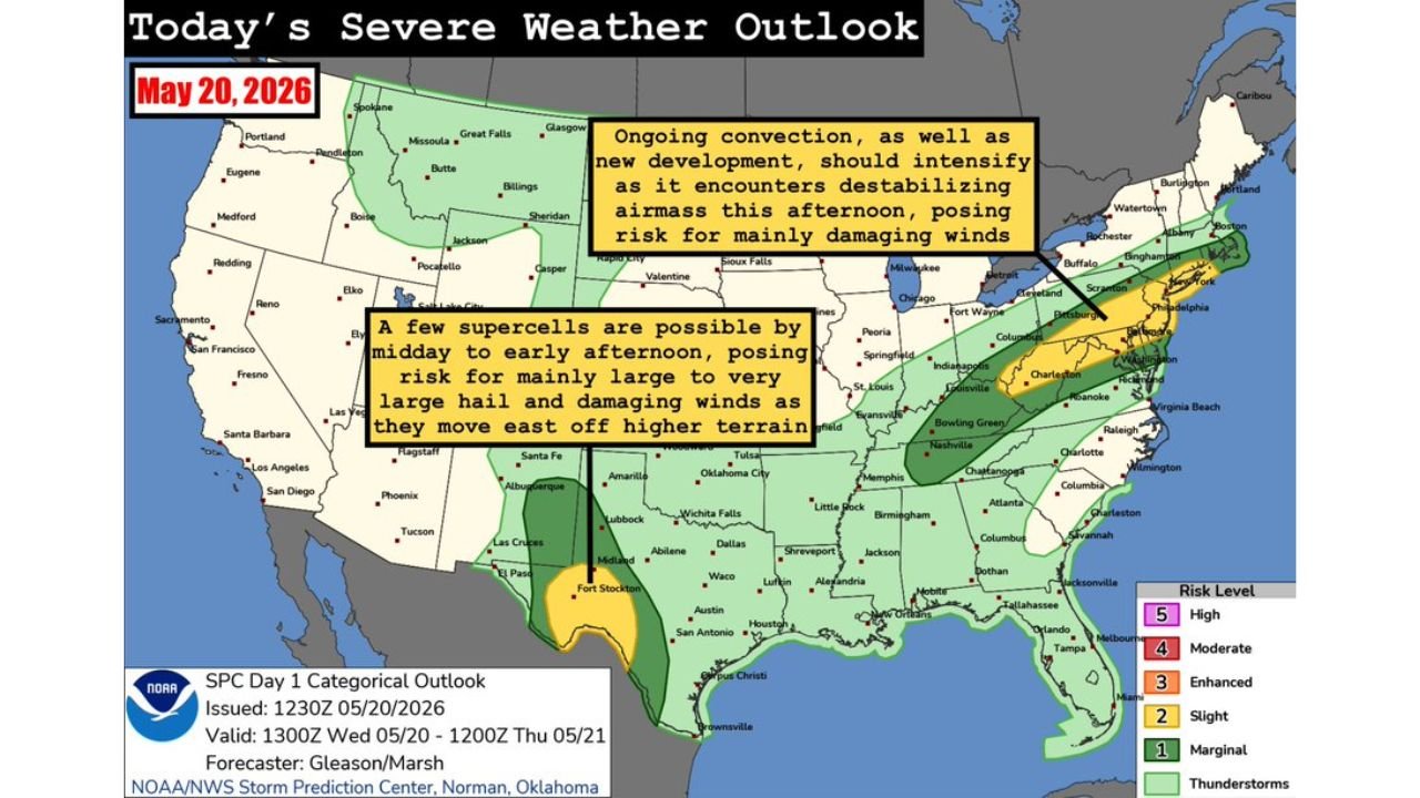
UNITED STATES — Two separate Slight Risk severe weather zones are active today, Wednesday, May 20, 2026, with the Storm Prediction Center identifying dangerous storm potential across west Texas and a second corridor stretching from the Ohio Valley into the Mid-Atlantic. The outlook was issued at 1230Z and is valid through 1200Z Thursday, May 21.
West Texas: Supercells With Very Large Hail and a Tornado Risk This Afternoon
The first threat zone sits over west Texas, where a few supercell thunderstorms are expected to develop on the higher terrain by early to mid-afternoon and push east as the day progresses. These storms carry a risk for mainly large to very large hail along with damaging winds as they move off the higher terrain. Forecasters also note that a tornado or two cannot be ruled out in this setup. As storms cluster later in the evening, the threat transitions toward a primarily hail and wind-driven event. Cities in the west Texas zone include Wichita Falls, Lubbock, Abilene, Midland, Fort Stockton, Waco, and Dallas.
Ohio Valley and Mid-Atlantic: Damaging Winds the Primary Threat This Afternoon
The second threat zone stretches from the Ohio Valley into the Mid-Atlantic, where ongoing convection and new storm development will intensify as storms encounter a destabilizing airmass this afternoon. The storm mode in this zone is expected to be mainly multicell-driven, making damaging winds the primary threat with isolated large hail also possible. Cities directly within this corridor include:
- Columbus and Indianapolis
- Fort Wayne and Evansville
- Louisville and Cincinnati
- Pittsburgh and Charleston, West Virginia
- Philadelphia and Washington D.C.
- Roanoke and Virginia Beach
- Charlotte and Raleigh
Full Risk Zone Summary for Today
| Risk Level | Coverage |
|---|---|
| Slight (2/5) | West Texas and Ohio Valley into Mid-Atlantic |
| Marginal (1/5) | Broader surrounding areas |
| Thunderstorms | Wide national coverage |
Two Different Threats Requiring Two Different Plans
Residents in west Texas need to be prepared for very large hail starting as early as midday and should have vehicles protected and outdoor plans adjusted before storms develop. Anyone in the Ohio Valley and Mid-Atlantic corridor should be on alert for damaging wind gusts developing through the afternoon hours as convection intensifies ahead of the destabilizing airmass.
Stay with CabarrusWeekly.com for live severe weather updates across both threat zones throughout Wednesday.