Central and Southern Indiana Drenched With Up to 5.74 Inches of Rain in 2 Days as Indianapolis Bloomington Columbus and Jasper Face More Rain Ahead of Race Weekend
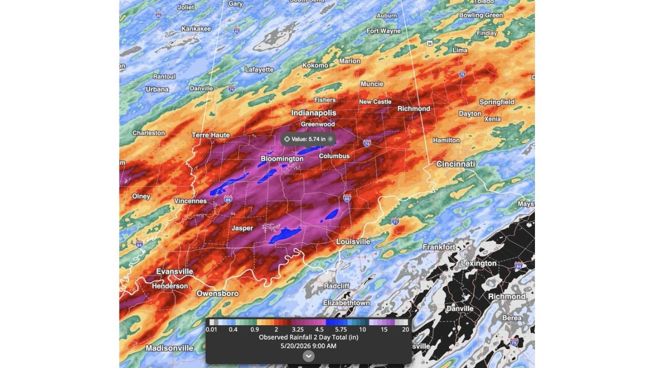
INDIANA — Central and southern Indiana have been hammered by widespread rainfall totals of 3 to 5 inches or more over just the past two days, with a peak observed total of 5.74 inches recorded near the Indianapolis and Bloomington corridor as of 9:00 AM on Wednesday, May 20, 2026. The rain is not stopping today, and more is expected this weekend, raising serious concerns ahead of the biggest event weekend of the year for Indianapolis.
What Has Already Fallen Across Indiana in 2 Days
The 2-day observed rainfall map through Wednesday morning tells a striking story. The core of the heaviest rainfall is centered over central and south-central Indiana, where totals have climbed well above 5 inches. A 5.74 inch reading was recorded near Bloomington, with similarly extreme totals across a broad area including Indianapolis, Greenwood, Columbus, Vincennes, and Jasper. Surrounding areas from Lafayette and Kokomo to Terre Haute and Evansville received 2 to 4 inches over the same period.
Rainfall Zone Breakdown Across the Region
| Rainfall Range | Cities and Areas |
|---|---|
| 5.75 inches and above | Bloomington, Columbus, Jasper, Greenwood core zone |
| 4.50 to 5.75 inches | Indianapolis, Vincennes, broader south-central Indiana |
| 3.25 to 4.50 inches | Terre Haute, broader central Indiana corridor |
| 2.00 to 3.25 inches | Lafayette, Kokomo, Evansville, Owensboro, Louisville |
| Under 2 inches | Fort Wayne, Cincinnati, outer surrounding areas |
The Rain Does Not Stop Here
What makes this situation especially concerning is that the wet pattern continues. More rain is expected to impact the region through this weekend, meaning communities already saturated from 3 to 5 inches of rainfall will have little to no recovery time before additional accumulations arrive. Rivers, streams, and drainage systems across central and southern Indiana are under significant stress right now.
Race Weekend in Indianapolis Now Under a Wet Cloud
The timing of this persistent wet pattern is particularly difficult for Indianapolis, as this weekend marks the biggest event weekend of the year for the city. Additional rainfall on top of already saturated ground and high water levels will only compound conditions heading into the weekend.
Flooding Remains the Top Concern
With ground saturation at critical levels across central and southern Indiana after two days of widespread heavy rain, flash flooding and river flooding remain the top concern for the region. Residents should avoid unnecessary travel near flooded roadways and waterways and continue monitoring conditions closely through the weekend.
Stay with CabarrusWeekly.com for ongoing flood and rainfall updates across Indiana through the weekend.