East Coast Surges 15 to 20 Degrees Above Normal for Mid-May While Central United States Plunges 10 to 15 Degrees Below Normal Creating a Remarkable Temperature Split Across the Country Wednesday May 20
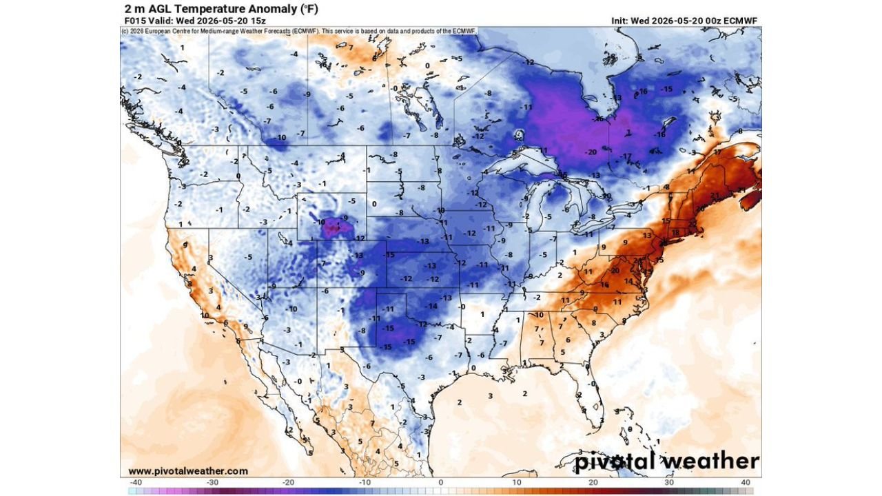
UNITED STATES — A dramatic temperature contrast is sweeping the country on Wednesday, May 20, 2026, with the East Coast running 15 to 20 degrees above normal for mid-May while the central United States sits 10 to 15 degrees below normal at the same time. The temperature anomaly map valid at 1500Z Wednesday shows one of the most striking coast-to-coast temperature splits seen this time of year.
The East Coast Is the Warm Star of the Day
For mid-May, the warmth gripping the East Coast and Mid-Atlantic is nothing short of remarkable. Temperature anomalies across the eastern seaboard are running 10 to 20 degrees above what is typical for this date, with the most extreme above-normal readings concentrated across the Northeast and Mid-Atlantic corridor. Anomalies of +13, +14, +15, +16, +18, and even +20 degrees above normal are present across this zone, making today a genuinely exceptional warm day for the middle of May.
The Central United States Is a Different Story Entirely
While the East Coast basks in record-challenging warmth, the central United States is locked in a significant cold pattern. Temperature anomalies across the Great Plains, Midwest, and into the southern states are running 10 to 15 degrees below normal, with the most extreme cold anomalies of -13, -14, and -15 degrees below normal present across portions of Kansas, Nebraska, Iowa, Missouri, Illinois, and Texas. The Great Lakes region is showing the most extreme cold departure on the entire map, with anomalies approaching -20 degrees below normal in the purple zone.
The Full Temperature Anomaly Picture
| Region | Temperature Departure From Normal |
|---|---|
| Northeast and Mid-Atlantic | 13 to 20 degrees ABOVE normal |
| California Coast | 5 to 10 degrees above normal |
| Southeast and Deep South | Near normal to slightly above |
| Great Plains and Midwest | 10 to 15 degrees BELOW normal |
| Great Lakes | Up to 20 degrees below normal |
| Texas and Oklahoma | 12 to 15 degrees below normal |
What This Contrast Means for Wednesday
This kind of sharp temperature gradient between the cold central states and the warm East Coast is precisely the type of atmospheric setup that fuels severe weather development along the boundary zone where these two air masses collide. Residents across the region where warm and cold air are meeting should remain weather-aware throughout the day as atmospheric instability increases along this sharp contrast zone.
Stay with CabarrusWeekly.com for continued weather coverage across this remarkable temperature pattern on Wednesday.