A Dangerous Day Is Here: Giant Hail, Damaging Winds, and Strong Tornadoes Likely From Texas Through the Midwest and Into the Northeast as Wisconsin, Illinois, Iowa, Oklahoma, and Texas Face the Highest Tornado Threat
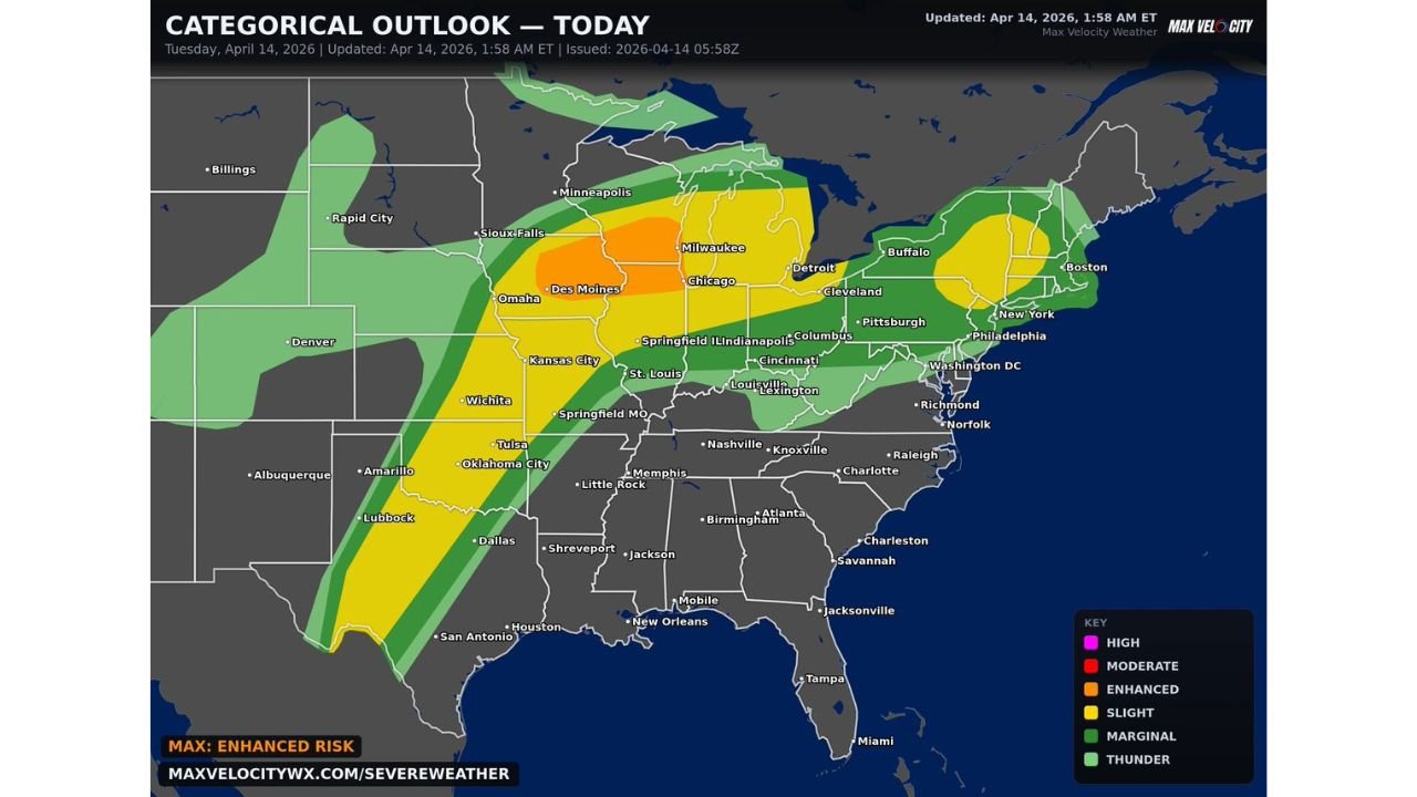
UNITED STATES — Tuesday April 14, 2026 is a dangerous day of severe weather across a massive stretch of the country. From Texas through the Midwest and all the way into the Northeast, a severe weather outbreak is underway today with giant hail, damaging winds, and a few strong tornadoes likely. The categorical outlook, updated April 14, 2026 at 1:58 AM ET and issued at 05:58Z, places the maximum risk at an Enhanced Risk — Level 3 of 5, and forecasters are identifying Wisconsin, Illinois, Iowa, Oklahoma, and Texas as the states carrying the highest tornado threat of the entire event.
An Enhanced Risk Outbreak Covering the Heart of the Country
The scope of today’s severe weather threat is extraordinary. The outbreak corridor stretches from San Antonio and Houston in south Texas northeast through Oklahoma City, Tulsa, Wichita, Kansas City, Des Moines, Chicago, Milwaukee and continues all the way into Buffalo, New York, Boston, Massachusetts, and the broader Northeast. This is one of the longest severe weather corridors of the season — spanning thousands of miles from the Gulf Coast to New England in a single outbreak.
Risk Zones — Tuesday April 14, 2026
| Risk Level | Cities and Areas Covered |
|---|---|
| Enhanced Risk — Level 3/5 | Des Moines, Chicago, Milwaukee, Detroit — the highest danger core |
| Slight Risk — Level 2/5 | Sioux Falls, Omaha, Kansas City, St. Louis, Springfield MO, Wichita, Oklahoma City, Tulsa, Springfield IL, Indianapolis, Columbus, Cincinnati, Louisville, Lexington, Pittsburgh, Cleveland, Buffalo, Philadelphia, New York City, Washington D.C. |
| Marginal Risk — Level 1/5 | Minneapolis, Dallas, Houston, San Antonio, Shreveport, Memphis, Nashville, Knoxville, Charlotte, Raleigh, Richmond, Norfolk, Boston, and broader surrounding areas |
| General Thunder | Outer edges of the corridor |
The Enhanced Risk core sits directly over the Des Moines, Chicago, and Milwaukee corridor — the zone where the highest tornado threat, the greatest hail potential, and the most dangerous supercell environment converge today. This aligns precisely with the states forecasters have specifically called out as carrying the highest tornado threat: Wisconsin, Illinois, and Iowa on the northern mode and Oklahoma and Texas on the southern mode.
The Three Headline Hazards for Today
Giant Hail The word giant is being used deliberately today — not large, not very large, but giant. Giant hail refers to hailstones at the extreme upper end of what thunderstorm updrafts can produce, and the Enhanced Risk environment in place today across the Des Moines, Chicago, and Milwaukee corridor is capable of supporting exactly that. Giant hail causes catastrophic damage to vehicles, destroys roofing, shatters glass, and is lethal to anyone caught outdoors without shelter.
Damaging Winds Widespread damaging wind gusts are expected across the entire outbreak corridor from Texas through the Northeast today. In a corridor this long and this active, damaging winds represent the most geographically widespread hazard of the event — capable of downing trees and power lines from Oklahoma City all the way to Buffalo and Philadelphia.
A Few Strong Tornadoes — Likely The tornado threat today is not marginal or conditional. A few strong tornadoes are described as likely — a forecast designation that reflects confidence in tornado development rather than mere possibility. The highest tornado threat specifically resides in Wisconsin, Illinois, Iowa, Oklahoma, and Texas — the five states sitting across the two distinct outbreak modes active simultaneously today.
The Five Highest Tornado Threat States and Why
| State | Reason for Elevated Tornado Threat |
|---|---|
| Wisconsin | Warm frontal zone, immense low-level shear — EF3-plus potential flagged by SPC |
| Illinois | Northern Illinois inside upgraded EF3-plus conditional tornado risk zone |
| Iowa | Eastern Iowa supercell initiation expected by 4 PM — direct tornado corridor |
| Oklahoma | Southern mode supercells along dryline — low-level jet intensification after dark |
| Texas | Southern extent of dryline supercell corridor — tornado threat ramping through evening |
City by City — Where You Stand Today
Enhanced Risk — Highest Danger:
| City | State |
|---|---|
| Des Moines | Iowa |
| Chicago | Illinois |
| Milwaukee | Wisconsin |
| Detroit | Michigan |
Slight Risk — Serious Threat:
| City | State |
|---|---|
| Sioux Falls | South Dakota |
| Omaha | Nebraska |
| Kansas City | Missouri |
| St. Louis | Missouri |
| Springfield MO | Missouri |
| Wichita | Kansas |
| Oklahoma City | Oklahoma |
| Tulsa | Oklahoma |
| Springfield IL | Illinois |
| Indianapolis | Indiana |
| Columbus | Ohio |
| Cincinnati | Ohio |
| Louisville | Kentucky |
| Lexington | Kentucky |
| Pittsburgh | Pennsylvania |
| Cleveland | Ohio |
| Buffalo | New York |
| Philadelphia | Pennsylvania |
| New York City | New York |
| Washington D.C. | District of Columbia |
Marginal Risk — Elevated Awareness Needed:
| City | State |
|---|---|
| Minneapolis | Minnesota |
| Dallas | Texas |
| Houston | Texas |
| San Antonio | Texas |
| Shreveport | Louisiana |
| Memphis | Tennessee |
| Nashville | Tennessee |
| Knoxville | Tennessee |
| Charlotte | North Carolina |
| Raleigh | North Carolina |
| Richmond | Virginia |
| Norfolk | Virginia |
| Boston | Massachusetts |
From Texas to Boston — The Full Outbreak Corridor
The geographic scope of today’s outbreak is one of its most striking characteristics. The severe weather corridor runs from San Antonio and Houston in south Texas all the way northeast through the heart of the country and into Boston and the broader Northeast — a corridor spanning virtually the entire eastern half of the United States in a single outbreak event.
This means that while the Enhanced Risk core over Des Moines, Chicago, and Milwaukee carries the greatest danger, no part of the country from Texas to New England is completely outside today’s threat zone. Cities as far apart as San Antonio and Boston, Houston and Buffalo, Dallas and Philadelphia are all sitting within some level of risk on today’s outbreak map.
Prepare Now — Have Multiple Ways to Receive Alerts
The message from forecasters is direct and urgent: prepare now and have multiple ways to receive weather alerts. In an outbreak of this geographic scope — covering the Enhanced Risk core in Wisconsin, Illinois, and Iowa while simultaneously targeting Oklahoma and Texas with the highest tornado threat — no single alert system is adequate.
- NOAA weather radio with battery backup — essential for the Enhanced Risk zone where power outages from damaging winds can knock out other alert systems before the most dangerous storms arrive
- Phone weather alerts — ensure county-level tornado warning notifications are active and your phone volume is not muted
- Multiple weather apps from different providers to ensure redundancy if one system fails to deliver
- Know your shelter location right now — not when the warning drops, right now — basement or lowest interior floor away from all windows
- Wisconsin, Illinois, Iowa, Oklahoma, and Texas residents specifically — these five states carry the highest tornado threat and need to be at the highest state of readiness throughout today
Today’s Full Outbreak Summary
| Factor | Details |
|---|---|
| Valid date | Tuesday April 14, 2026 |
| Updated | April 14, 2026 at 1:58 AM ET |
| Maximum risk | Enhanced — Level 3 of 5 |
| Enhanced Risk core | Des Moines, Chicago, Milwaukee, Detroit |
| Highest tornado threat states | Wisconsin, Illinois, Iowa, Oklahoma, Texas |
| Primary hazards | Giant hail, damaging winds, strong tornadoes — likely |
| Outbreak corridor | Texas through Midwest into Northeast |
| Southern extent | San Antonio, Houston, Dallas |
| Northern extent | Minneapolis, Milwaukee, Detroit |
| Eastern extent | Buffalo, New York City, Philadelphia, Boston |
Today Is Dangerous — From Texas to the Northeast
Giant hail. Damaging winds. Strong tornadoes likely. The Enhanced Risk over Des Moines, Chicago, and Milwaukee combined with the highest tornado threat across Wisconsin, Illinois, Iowa, Oklahoma, and Texas makes Tuesday April 14 one of the most significant severe weather days of the year across the eastern United States.
Prepare now. Have multiple alert methods active. Know your shelter. The outbreak corridor runs from Texas all the way to Boston — and the time to act is before the storms arrive, not when the warnings are already dropping.
Stay with CabarrusWeekly.com for live Tuesday outbreak coverage, tornado and severe thunderstorm warnings as they are issued across the Enhanced Risk corridor, and real-time storm reports from Texas through the Midwest and into the Northeast throughout today’s dangerous severe weather event.