Upgraded to EF3-Plus: The Storm Prediction Center Now Warning of Violent Tornadoes Between Dubuque, Rockford, and Madison Today as Dangerous Supercells Target Southern Wisconsin, Eastern Iowa, and Northern Illinois
DUBUQUE, IOWA — Tuesday April 14 just got significantly more dangerous. The Storm Prediction Center has upgraded the tornado threat for the corridor between Dubuque, Rockford, and Madison, and the new language being used is as serious as it gets in severe weather forecasting. Tornadoes may reach EF3 or greater strength in the strongest storms today — violent, potentially catastrophic tornadoes capable of leveling well-built homes and throwing vehicles significant distances. The upgrade also extends through the Platteville to Janesville to Freeport stretches, and forecasters are delivering a blunt message to anyone in southern Wisconsin, eastern Iowa, or northern Illinois: today is really a day to remain weather aware.
The Upgrade — EF3-Plus Is Now on the Table
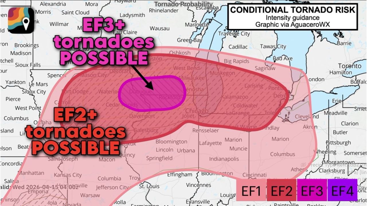
This is not a routine severe weather statement. The Storm Prediction Center specifically noting that tornadoes may reach EF3 or greater in the strongest storms is an escalation that places today’s event in a different category from a standard tornado threat. The conditional tornado risk graphic, issued via AguaceroWX and valid Wednesday April 15, 2026 at 04:00Z, defines two overlapping zones of violent tornado potential centered on the Dubuque, Rockford, and Madison corridor.
| Tornado Risk Zone | Intensity | Core Area |
|---|---|---|
| Inner zone — highest danger | EF3-plus tornadoes possible | Dubuque, Rockford, Madison — the direct bullseye |
| Outer zone | EF2-plus tornadoes possible | Southern Wisconsin, eastern Iowa, northern Illinois, extending toward Chicago, Joliet, Kalamazoo, Toledo, Cleveland, and Pittsburgh corridor |
The EF3-plus inner zone sits as a defined oval directly over the Dubuque to Rockford to Madison corridor — the exact stretch where the SPC is specifically flagging violent tornado potential today. The EF2-plus outer zone fans broadly around that core, reaching across a massive area from eastern Iowa through Illinois, Indiana, Ohio, and into western Pennsylvania.
What EF3-Plus Actually Means on the Ground
The upgrade to EF3-plus potential is not a number — it is a description of destruction. Understanding what an EF3 or stronger tornado does to structures and communities in its path matters enormously today.
| Rating | Wind Speed | What It Does |
|---|---|---|
| EF2 | 111-135 mph | Roofs torn off, mobile homes destroyed, large trees uprooted |
| EF3 | 136-165 mph | Entire floors of well-built homes destroyed, trains overturned, most trees uprooted |
| EF4 | 166-200 mph | Well-constructed homes leveled to foundations, cars thrown significant distances |
An EF3 tornado destroys the floors of well-built homes — not just the roof, entire floors. Structures that would survive an EF1 or EF2 tornado are rendered uninhabitable or completely destroyed by EF3 winds. The only survivable location in an EF3 or stronger tornado is below ground — a basement, storm shelter, or underground safe room. Interior rooms on the lowest floor without a basement provide significantly reduced protection against a tornado of this magnitude.
The Specific Corridor — Dubuque to Rockford to Madison
The SPC’s explicit identification of the Dubuque to Rockford to Madison corridor as the zone where EF3-plus tornadoes are possible today is precise and meaningful. This is not a broad regional warning — it is a specific geographic corridor that forecasters have identified as the most dangerous stretch in today’s outbreak.
The upgrade also extends through the Platteville to Janesville to Freeport stretches — communities that sit between and around the primary Dubuque-Rockford-Madison corridor and fall within the EF3-plus conditional risk zone.
Cities Inside the EF3-Plus Inner Zone
| City | State |
|---|---|
| Dubuque | Iowa |
| Rockford | Illinois |
| Madison | Wisconsin |
| Platteville | Wisconsin |
| Janesville | Wisconsin |
| Freeport | Illinois |
Every community between these cities along the corridor connecting them sits inside the zone where the SPC has flagged EF3-plus tornado potential today.
Cities Inside the EF2-Plus Outer Zone
The broader EF2-plus zone extends across a massive and densely populated corridor that includes some of the largest cities in the Midwest and Great Lakes region.
| City | State |
|---|---|
| Milwaukee | Wisconsin |
| Kenosha | Wisconsin |
| Oshkosh | Wisconsin |
| Wausau | Wisconsin |
| Eau Claire | Wisconsin |
| Green Bay | Wisconsin |
| Chicago | Illinois |
| Joliet | Illinois |
| Bloomington | Illinois |
| Springfield | Illinois |
| Urbana | Illinois |
| Davenport | Iowa |
| Mason City | Iowa |
| Waterloo | Iowa |
| Cedar Rapids | Iowa |
| Fort Dodge | Iowa |
| Kalamazoo | Michigan |
| Lansing | Michigan |
| Detroit | Michigan |
| Toledo | Ohio |
| Cleveland | Ohio |
| Akron | Ohio |
| Columbus | Ohio |
| Indianapolis | Indiana |
| Fort Wayne | Indiana |
| Lafayette | Indiana |
| Muncie | Indiana |
| Pittsburgh | Pennsylvania |
| Wheeling | West Virginia |
The EF2-plus outer zone covers one of the most densely populated corridors in the United States — from the Chicago and Milwaukee metro areas east through Detroit, Toledo, Cleveland, Columbus, and Pittsburgh. Every city in this zone faces a genuine and elevated violent tornado threat today.
A Few Dangerous Supercells Are Likely — Baseball-Sized Hail Also Possible
Forecasters are clear that today’s tornado threat comes from a few dangerous supercells — not a widespread line of storms. Discrete, organized supercells are the most prolific tornado producers in meteorology, and in an environment where EF3-plus tornado potential has been flagged, a few well-organized supercells are more dangerous than dozens of weaker storm clusters.
In addition to the violent tornado threat, these same supercells are capable of producing baseball-sized hail — hail measuring 2.75 inches in diameter that falls at speeds sufficient to shatter vehicle glass, punch through roofing, and cause serious injury to anyone caught outdoors.
The combination of EF3-plus tornado potential and baseball-sized hail from a few dangerous supercells makes today one of the most significant severe weather events of the season across the southern Wisconsin, eastern Iowa, and northern Illinois corridor.
Multiple Warning Methods Are Essential Today
Forecasters are delivering a specific and urgent directive: have multiple ways to be notified of any warnings and be ready to exercise your severe weather plans. In a violent tornado event, having only one warning method is not adequate. Any single system can fail — power can go out, cell service can be disrupted, and outdoor sirens cannot be heard from inside a home with windows closed.
Multiple warning methods for today must include:
- NOAA weather radio with battery backup — programmed for your specific county and capable of waking you even if power is out
- Phone weather app alerts — ensure county-level tornado warning notifications are active and your phone is not on silent
- Multiple weather apps from different providers so that if one fails to deliver an alert, another catches it
- A trusted neighbor or family member who can also alert you if communications fail
What to Do Right Now — Before the Supercells Fire
A few dangerous supercells are likely today. The window for preparation is closing. Every action taken before those supercells develop is a life-safety action.
- Get underground now — identify your basement or storm shelter and ensure it is accessible, cleared, and ready before storms approach
- If you do not have a basement, identify the lowest floor interior room furthest from windows in the most substantial structure available to you — and understand that this provides significantly reduced protection against EF3-plus tornadoes
- Mobile home and manufactured home residents in the EF3-plus zone — evacuate to a substantial structure with a basement immediately. No mobile home provides survivable protection from an EF3 tornado
- Cancel all outdoor plans in southern Wisconsin, eastern Iowa, and northern Illinois today — baseball-sized hail and EF3-plus tornado potential make any outdoor activity life-threatening when storms approach
- Exercise your severe weather plan with your family right now — walk through exactly what everyone does, exactly where everyone goes, and exactly how you will communicate if separated when a tornado warning is issued
Tuesday April 14 Tornado Upgrade — Full Summary
| Factor | Details |
|---|---|
| Upgrade | Strong tornado risk — EF3-plus now possible |
| Issued by | Storm Prediction Center |
| Graphic valid | Wednesday April 15, 2026 at 04:00Z |
| EF3-plus inner zone | Dubuque, Rockford, Madison, Platteville, Janesville, Freeport |
| EF2-plus outer zone | Chicago, Milwaukee, Detroit, Toledo, Cleveland, Columbus, Indianapolis, Pittsburgh |
| Storm type | A few dangerous discrete supercells |
| Additional hazard | Baseball-sized hail |
| States most affected | Southern Wisconsin, eastern Iowa, northern Illinois |
| Critical action | Multiple warning methods active, severe weather plans ready |
EF3-Plus Between Dubuque, Rockford, and Madison — This Is the Real Thing
The Storm Prediction Center does not use EF3-plus language casually. When the SPC tells you tornadoes may reach EF3 or greater between Dubuque, Rockford, and Madison — and through Platteville, Janesville, and Freeport — they are telling you that violent, catastrophic tornadoes are a genuine and specific possibility in your community today.
Southern Wisconsin, eastern Iowa, and northern Illinois — today is really a day to remain weather aware. A few dangerous supercells are likely. Baseball-sized hail is possible. EF3-plus tornadoes are on the table. Have multiple warning methods active. Have your severe weather plan ready to execute immediately. And get underground when warnings are issued — above-ground shelter is not adequate protection from a violent tornado.
Stay with CabarrusWeekly.com for live Tuesday severe weather coverage, EF3-plus tornado warning updates across the Dubuque, Rockford, and Madison corridor, and real-time storm reports from southern Wisconsin, eastern Iowa, and northern Illinois throughout today’s dangerous and upgraded severe weather event.