Severe MCS Hammers San Antonio, Jourdanton, and South Texas Tonight With Strong to Severe Wind Gusts Continuing for at Least the Next Two Hours
SAN ANTONIO, TEXAS — A severe Mesoscale Convective System is actively moving through South Texas as of 9:40 PM CDT Tuesday May 26, 2026, producing a swath of strong to severe wind gusts across San Antonio, Jourdanton, Devine, Floresville, Cotulla, and the broader south Texas corridor. The storm line is expected to continue producing damaging winds for at least the next couple of hours as it pushes through the region.
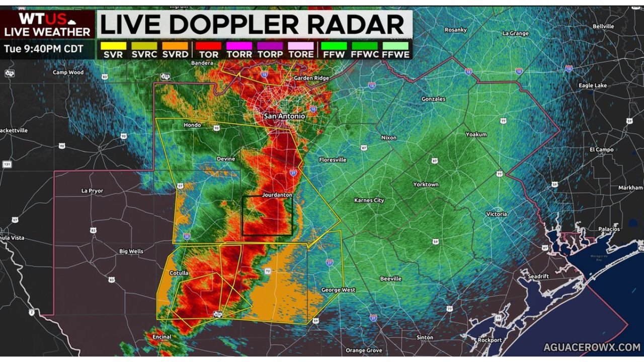
What Live Doppler Radar Shows at 9:40 PM CDT
The live radar confirms an intense and organized storm line tracking through south Texas with multiple active warning polygons overlapping the metro and surrounding counties.
Current radar and warning conditions by area:
| Location | Radar Status | Active Warnings |
|---|---|---|
| San Antonio metro | Intense red and orange returns | Multiple overlapping warnings |
| Jourdanton | Deep red returns, heaviest cells | Within black warning box |
| Devine | Heavy red returns | Severe warning zone |
| Floresville | Orange and red returns moving through | Warning area |
| Cotulla | Heavy orange returns | Warning polygon active |
| Hondo | Active returns on western edge | Approaching warning zone |
| George West | Green to yellow returns approaching | Downstream of main line |
| Victoria corridor | Green returns, line approaching | Flash flood watch area |
Active Warning Products Visible on Radar
The radar display shows multiple overlapping warning polygons across the south Texas region.
Warning products active as of 9:40 PM CDT:
| Warning Code | Type |
|---|---|
| SVR | Severe Thunderstorm Warning |
| SVRC | Severe Thunderstorm Warning Considerable |
| SVRD | Severe Thunderstorm Warning Destructive |
| FFW | Flash Flood Warning |
| FFWC | Flash Flood Warning Considerable |
| FFWE | Flash Flood Warning Emergencies |
The presence of SVRD (Destructive) and FFWE (Flash Flood Emergency) level products indicates this is not a routine severe weather event. These are the highest tier warning products issued for their respective hazard categories.
What an MCS Means for the Wind Threat
A Mesoscale Convective System is a large and organized cluster of thunderstorms that generates its own wind field as it matures. Unlike isolated thunderstorms, an MCS can produce widespread damaging wind gusts across a broad swath simultaneously rather than in isolated pockets.
MCS wind threat characteristics:
- Swath of damaging winds rather than isolated gust events
- Bow echo structure common with severe MCS events amplifies wind production
- Winds can arrive with very little warning ahead of the main radar returns
- Duration of wind threat extends for at least two more hours across the south Texas corridor
- Downed trees and power lines are likely along the path of the most intense cells
Communities in the Immediate Path
Areas currently being impacted or directly in the path:
- San Antonio and surrounding suburbs directly in the heart of the storm line
- Jourdanton inside the most intense warning box on the current radar
- Devine taking heavy rainfall and wind impacts
- Floresville in the active warning zone east of the main line
- Cotulla under active severe warning polygon to the south
- George West and Beeville downstream and will see the line arrive within the next one to two hours
What South Texas Residents Must Do Right Now
- Stay indoors and away from windows immediately
- Secure or bring inside any outdoor furniture, equipment, or loose items
- Avoid all travel across the south Texas corridor until the line clears
- Do not drive through flooded roadways with Flash Flood Warnings and Emergencies active
- Have flashlights ready as widespread power outages are likely with destructive-level wind warnings
- Move to an interior room on the lowest floor if warnings are upgraded further in your area
Stay with CabarrusWeekly.com for continuing updates on the south Texas MCS and severe weather threat through Tuesday night.