Chaotic Upper Air Pattern Locks Over Washington, Oregon, California, Texas, Louisiana, New York, and the Eastern Seaboard as Weak MJO Signal Leaves Models Struggling to Find Answers
UNITED STATES — A deeply disorganized upper air pattern is dominating the country’s weather setup heading into late May 2026, with a tangled web of high and low pressure systems creating one of the more confusing atmospheric configurations forecasters have seen this season.
Four Low Pressure Systems and Three Highs Battle for Control Across the Continent
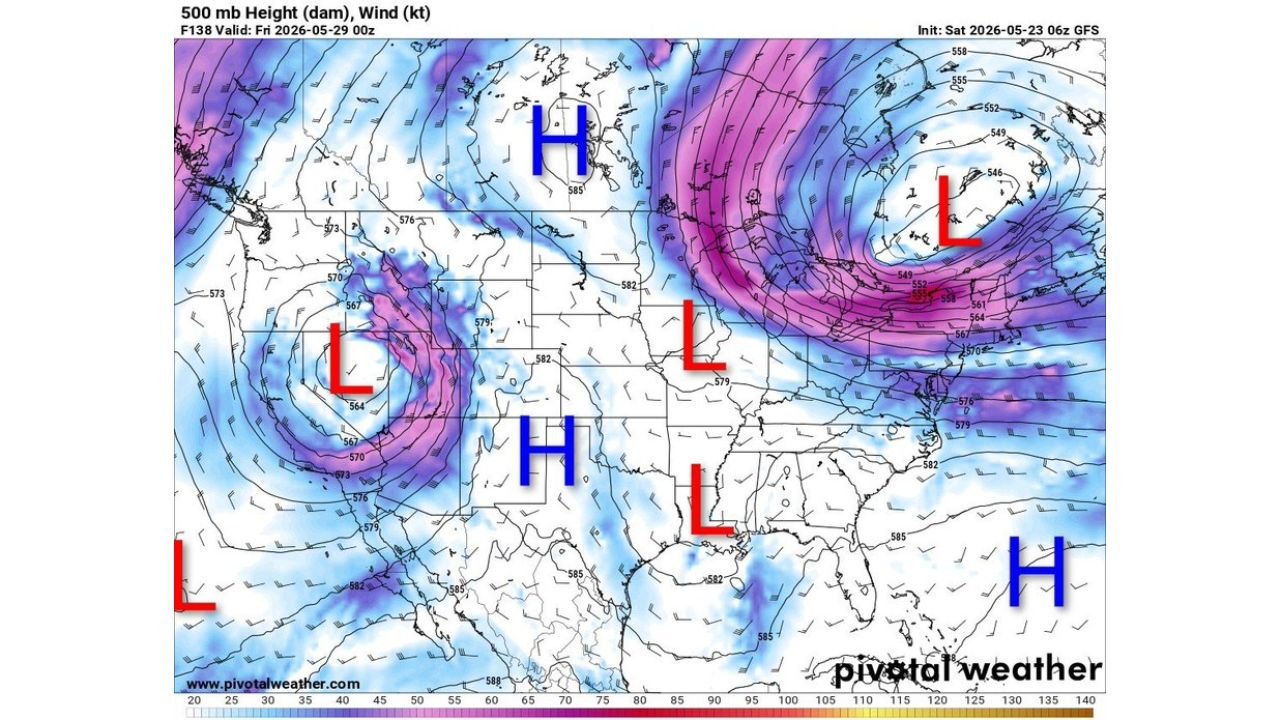
The 500 mb height map, initialized Saturday May 23, 2026 at 06z by the GFS model and valid for Friday May 29, 2026, shows an unusually fragmented pressure pattern stretched from the Pacific Coast to the Atlantic Seaboard.
Pressure system breakdown:
| System | Location |
|---|---|
| Low (L) | Pacific Coast / Western U.S. |
| Low (L) | Central U.S. / Plains |
| Low (L) | Southern U.S. / Gulf Region |
| Low (L) | Northeast U.S. / Atlantic |
| High (H) | Canada / Northern U.S. |
| High (H) | Central U.S. |
| High (H) | Atlantic / Southeast Coast |
That is four separate low pressure systems and three high pressure systems all competing across the country at the same time, an unusually crowded and disorganized setup for late May.
Why Forecasters Are Struggling to Make Sense of This Pattern
This kind of setup creates serious problems for weather models and forecasters alike.
- Multiple competing pressure systems pull the atmosphere in different directions simultaneously
- No single dominant feature means no clean, predictable storm track exists across the country
- Fragmented atmospheric energy cannot consolidate into one organized system
- Model runs cannot agree on outcomes when the atmosphere itself is this unsettled
- A weak MJO signal is removing the one tool forecasters rely on to find large-scale organization
When pressure systems compete like this across multiple regions at once, forecast accuracy drops significantly even just a few days out.
The MJO Is the Missing Piece
The Madden-Julian Oscillation (MJO) is a large-scale wave of enhanced and suppressed rainfall and atmospheric energy that circles the tropics roughly every 30 to 60 days. During active and strong phases, it acts as a steering mechanism for global weather patterns, giving forecasters a reliable signal weeks in advance.
Right now the MJO signal is too weak to provide that guidance. Without it, the mid-latitude atmosphere is running without a clear organizing force, allowing multiple disconnected systems to develop and compete simultaneously. The result is the chaotic map now valid through the final days of May 2026.
What Residents Across the Country Should Expect
With no dominant pattern in control, weather conditions through the end of May will be difficult to nail down by region.
- Day-to-day forecast confidence is lower than normal across most of the country
- Storm systems may develop, stall, or fall apart with little warning
- Temperature swings are possible as competing air masses clash
- Rainfall will be uneven and spotty, difficult to predict by specific location
- Model guidance should be treated with caution at extended ranges until the pattern simplifies
No Clear Resolution in Sight Before Month End
With the MJO signal remaining weak and no single pressure system positioned to dominate the pattern, forecasters do not expect the atmospheric chaos to resolve quickly. The GFS model is already struggling to produce consistent solutions run to run, a direct reflection of how truly unsettled this setup is.
Residents across Washington, Oregon, California, Texas, Louisiana, New York, and the broader Eastern Seaboard should monitor local forecasts closely and avoid locking in plans based on extended range outlooks until the pattern begins to organize.
Stay with CabarrusWeekly.com for continuing updates as this complex weather pattern evolves through the end of May.