Maryland Soaks Up 2 to 4 Inches of Rain Since Mid-Week as BWI Approaches 4 Inches for May With More Showers and Storms Returning Monday
MARYLAND — A multi-day soaking rainfall event has delivered 2 to 3 inches of rain across most of Maryland since the middle of last week, with BWI Airport now approaching 4 inches for the month of May. The rain is not finished, with scattered showers and storms expected to return Monday as a fresh round of moisture pushes back into the region.
How Much Rain Has Fallen Across Maryland Since Mid-Week
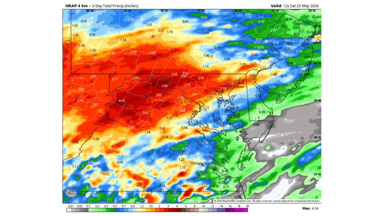
The 3-day total precipitation map valid at 12z Saturday May 23, 2026 shows the full scope of rainfall across the region.
3-day rainfall totals by area:
| Location | Rainfall Total |
|---|---|
| Western Maryland / Highest totals | 4.05 inches |
| Central Maryland | 2.62 to 3.82 inches |
| Baltimore metro area | 2.04 to 2.95 inches |
| Eastern Shore upper | 1.57 to 2.59 inches |
| Eastern Shore lower | 0.54 to 1.12 inches |
| Coastal / Southern Delaware | 0.06 to 0.73 inches |
| Maximum recorded value | 4.54 inches |
The heaviest totals are concentrated across western and central Maryland, with values dropping significantly as you move east toward the coast and Delaware.
What Fell Just Since Midnight Sunday
The Maryland Mesonet rainfall map observed at 8:35 AM EDT on May 24, 2026 shows additional accumulation on top of what already fell earlier in the week.
Rainfall since midnight Sunday by county zone:
| Area | Since Midnight Total |
|---|---|
| Central Maryland / Anne Arundel area | 1.32 to 1.46 inches |
| Northern Maryland | 0.91 to 1.26 inches |
| Eastern Shore upper | 0.59 to 1.02 inches |
| Baltimore area | 0.64 to 0.96 inches |
| Southern Maryland | 0.17 to 0.38 inches |
| Far Eastern Shore | 0.02 to 0.16 inches |
| Western Maryland | 0.02 to 0.05 inches |
Central Maryland picked up the most overnight, with some locations adding over 1.40 inches since midnight alone.
BWI Airport Closing In on 4 Inches for May
Baltimore Washington International Airport has recorded nearly 4 inches of rainfall for the month of May, a significant total that reflects just how active and wet this pattern has been for the greater Baltimore and central Maryland region. For context, that figure represents a substantial above normal monthly total for a single station.
Rain Is Not Done Yet for Maryland
Despite the impressive totals already on the books, the pattern is not finished delivering moisture to the region.
What is still ahead:
- Sunday remainder — A few isolated shower chances possible through the day
- Monday May 25 — Scattered showers and thunderstorms return across the region
- Not a washout but another round of meaningful rainfall is expected
- Memorial Day outdoor plans should remain flexible given the returning storm chances
Monday Radar Already Being Tracked by Models
The RRFS Experimental model initialized at 06z May 24, 2026, valid for 4:00 PM Monday May 25, 2026, shows a broad swath of green and yellow radar returns pushing across Maryland, northern Virginia, and southern Pennsylvania by Monday afternoon. A corridor of heavier cells is indicated across central Maryland into the Baltimore and Washington D.C. metro area, with additional activity scattered across western Virginia and into the Shenandoah Valley.
This confirms that Monday will not be a fully dry day across the region, with the heaviest activity most likely during the afternoon and evening hours.
A Wet May Continues to Build Across Maryland
The combination of mid-week totals, overnight accumulation, and the returning Monday storm chances means May 2026 will go on record as a significantly above normal precipitation month for much of Maryland. While the rainfall is welcome from a drought relief standpoint, repeated rounds of heavy rain also carry flooding concerns for areas where soils are already saturated after days of continuous moisture.
Stay with CabarrusWeekly.com for continuing updates on Maryland’s Memorial Day weekend rainfall and the Monday storm outlook across the region.