East and Southeast Alabama Face Marginal Risk of Severe Thunderstorms This Afternoon as Large Rain Areas Continue Moving Across the State With No Tornado Threat
ALABAMA — Large areas of rain continue moving across Alabama on the morning of Sunday May 24, 2026, with a low end marginal risk of severe thunderstorms developing this afternoon across East and Southeast Alabama. Heavier storms capable of producing gusty winds and frequent lightning are possible, though forecasters confirm there is no tornado threat with this event.
What the Radar Is Showing Right Now
Live radar valid at 1400z Sunday May 24, 2026 shows a broad area of green and yellow radar returns pushing across central and southern Alabama, with the heaviest cells concentrated along a corridor from central Alabama southward through the Mobile area.
Current radar conditions by area:
| Area | Current Condition |
|---|---|
| Central Alabama | Widespread green and yellow returns |
| Birmingham metro | Active rainfall moving through |
| Southern Alabama | Heavy cells pushing toward Gulf Coast |
| Mobile area | Active moderate to heavy returns |
| East Alabama | Developing activity, afternoon threat area |
| North Alabama | Lighter scattered activity |
The maximum reflectivity value recorded on the current radar is 60.5 dBZ, indicating at least some cells with significant intensity already embedded in the broader rain mass.
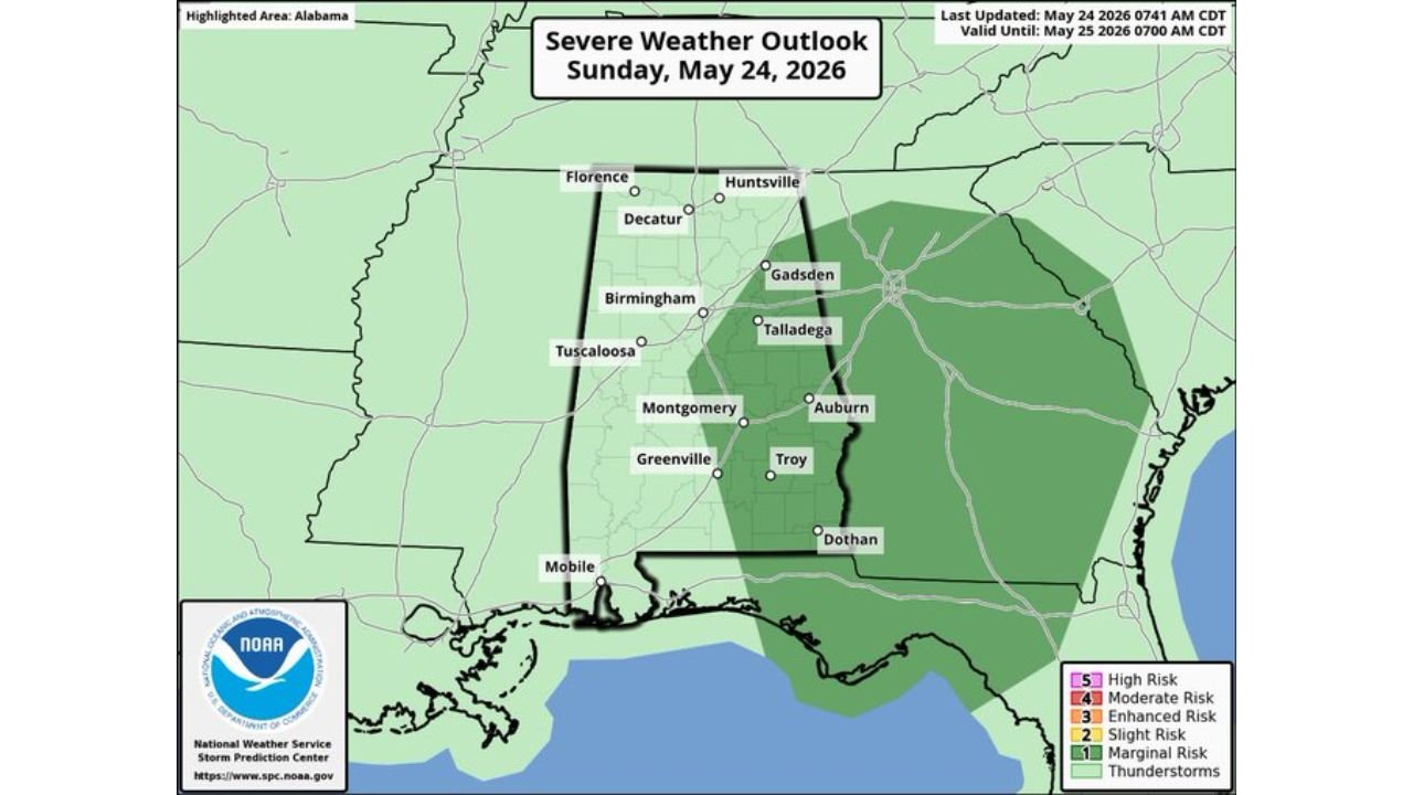
Where the Severe Weather Risk Is Focused This Afternoon
The SPC Severe Weather Outlook updated at 0741 AM CDT May 24, 2026, valid until 7:00 AM CDT Monday May 25, places the threat zone clearly over the eastern half of the state.
Risk breakdown by area:
| Risk Level | Zone | Cities Included |
|---|---|---|
| Marginal Risk (1/5) | East and Southeast Alabama | Gadsden, Talladega, Auburn, Troy, Dothan, Mobile |
| General Thunderstorms | Central Alabama | Birmingham, Montgomery, Tuscaloosa |
| No Risk Outlined | North Alabama | Florence, Huntsville, Decatur |
The marginal risk zone extends well east of Alabama into portions of Georgia and the Florida Panhandle region, but the Alabama focus is clearly on the eastern and southeastern counties this afternoon.
Tornado Outlook Confirms Zero Threat Across All of Alabama
The SPC Tornado Outlook for Sunday May 24, 2026 is unambiguous. The entire state of Alabama sits in blank white on the tornado probability map, meaning zero tornado probability has been assigned anywhere across the state for this event.
Tornado threat summary:
| Area | Tornado Probability |
|---|---|
| All of Alabama | Zero percent |
| North Alabama | Zero percent |
| Central Alabama | Zero percent |
| East and Southeast Alabama | Zero percent |
This is a wind and lightning threat only with this afternoon’s storm potential, not a tornado event.
Hazards to Expect With Stronger Storms This Afternoon
For residents across East and Southeast Alabama, the storm threats are focused and specific.
- Gusty winds with heavier storm cells as they develop this afternoon
- Frequent lightning with any organized convection
- Heavy downpours reducing visibility quickly on arrival
- No tornado threat confirmed across the entire state
- Localized flooding possible in areas already saturated from earlier rainfall
What East and Southeast Alabama Residents Should Do
With the marginal risk zone covering Gadsden, Talladega, Auburn, Troy, Dothan, and Mobile through this afternoon and evening, residents in those communities should take straightforward precautions.
- Stay weather aware through the afternoon and early evening hours
- Seek shelter indoors when thunder is heard or lightning is observed
- Avoid open areas, tall trees, and water during any storm activity
- Keep outdoor plans flexible as storm development timing can shift quickly
- Monitor local conditions as heavier cells may develop with little lead time
Rain Continues Through the Day Before Pattern Evolves
The broad rain mass currently moving across Alabama is not the same threat as the afternoon severe potential. The large areas of widespread rain will continue tracking through the morning before afternoon heating increases instability and sets the stage for stronger storm development across the eastern counties.
North Alabama, including Florence, Huntsville, and Decatur, remains outside the risk zone entirely and is expected to see lighter and less organized precipitation through the day.
Stay with CabarrusWeekly.com for continuing updates on Alabama’s severe weather outlook and storm timing through Sunday afternoon and evening.