Burn Ban in Effect and Wildfires Could Spread Fast: Special Weather Statement Puts the Western Piedmont and Sandhills on High Fire Danger Alert Through 8 PM as Gusty Winds and Bone-Dry Conditions Grip Person, Forsyth, Cabarrus, and Surrounding Counties
CONCORD, NORTH CAROLINA — A Special Weather Statement is in effect today across a wide swath of central North Carolina, and the message from forecasters is direct and urgent. Extremely dry fuels, gusty winds, and critically low relative humidity are combining to create conditions where fast-spreading wildfires can ignite and race across the landscape with little warning. A burn ban is in effect across the affected area, and residents are being told clearly — no open burning, avoid sparks, and dispose of any smoking materials properly before early this evening.
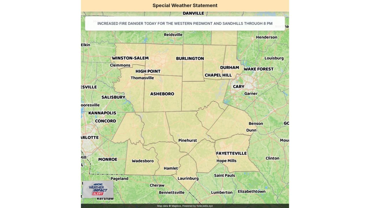
Special Weather Statement — Increased Fire Danger Through 8 PM
The Special Weather Statement covers the Western Piedmont and Sandhills of North Carolina and is in effect through 8 PM today. The statement specifically names Person and Forsyth counties among those under the elevated fire danger, with additional counties across the broader region also included in the warning area.
The combination of conditions in place today creates a dangerous and highly efficient fire environment:
- Extremely dry fuels — vegetation across the region is critically dry after a prolonged period of below-normal rainfall and drought, creating abundant ready-to-burn material across fields, forests, and roadside brush
- Gusty winds — wind gusts today are sufficient to rapidly spread any fire that ignites, carrying embers ahead of the flame front and expanding fire perimeters faster than suppression crews can respond
- Low relative humidity — critically low RH values are removing what little moisture remains in surface fuels, making ignition easier and fire behavior more extreme
When all three of these ingredients are present simultaneously — dry fuels, gusty winds, and low humidity — any spark can become a fast-moving and dangerous wildfire within minutes.
Counties and Cities Under the Fire Danger Alert
The Special Weather Statement covers a large portion of central North Carolina across the Western Piedmont and Sandhills regions. The following areas are within or immediately adjacent to the elevated fire danger zone:
| County or Area | Cities Included |
|---|---|
| Forsyth County | Winston-Salem, Clemmons |
| Cabarrus County | Concord, Kannapolis |
| Rowan County | Salisbury, Mooresville |
| Randolph County | Asheboro, Thomasville area |
| Alamance County | Burlington |
| Guilford County | High Point |
| Durham County | Durham |
| Orange County | Chapel Hill |
| Wake County | Wake Forest, Cary, Garner |
| Union County | Monroe |
| Anson County | Wadesboro |
| Richmond County | Hamlet |
| Scotland County | Laurinburg |
| Hoke County | Raeford area |
| Moore County | Pinehurst |
| Cumberland County | Fayetteville, Hope Mills |
| Harnett County | Dunn, Benson |
| Sampson County | Clinton |
| Robeson County | Lumberton, Saint Pauls |
| Bladen County | Elizabethtown |
| Person County | Roxboro area |
Concord and Kannapolis in Cabarrus County sit directly within the fire danger zone — making this a locally significant weather statement for CabarrusWeekly.com readers and the communities this outlet serves. Residents across Cabarrus County need to take today’s fire danger conditions seriously through 8 PM.
The Burn Ban — What It Means and Why It Matters
A burn ban is in effect across the affected counties today. This is not a recommendation or a suggestion — it is a formal restriction on open burning that applies to the entire affected area through this evening.
Under a burn ban, the following activities are prohibited or strongly restricted:
- No open burning of any kind — yard debris, brush piles, agricultural burning, and recreational fires are all included
- No burning of trash or organic material outdoors
- Campfires and fire pits are prohibited in the affected area during the burn ban period
- Smoking outdoors requires extreme caution — cigarette butts and matches must be disposed of properly and completely extinguished
The reasoning is straightforward. In today’s conditions — extremely dry fuels, gusty winds, and low relative humidity — an improperly discarded cigarette butt or a burning ember from a small fire can be carried by wind into dry grass or brush and ignite a fast-moving wildfire within seconds. These are not conditions where a small fire stays small.
Fast-Spreading Wildfires Are the Primary Danger
The specific language in today’s Special Weather Statement describes the risk of fast-spreading wildfires through early this evening. In the fire weather conditions present today across the Western Piedmont and Sandhills, a wildfire that ignites can:
- Spread faster than people can evacuate from nearby structures or vehicles
- Outrun firefighting equipment before aerial or ground suppression resources can be positioned
- Jump roads, firebreaks, and natural barriers when gusty winds carry burning embers ahead of the flame front
- Threaten structures, vehicles, and lives in rural and suburban areas alike across the fire danger zone
The drought conditions that have been building across central North Carolina through the winter and early spring have left fuels in a critically receptive state for rapid fire spread. Today’s gusty winds and low humidity are the trigger conditions that turn those dry fuels into an active fire danger.
What Cabarrus County and Surrounding Residents Must Do Right Now
The fire danger window runs through 8 PM today. Every action taken before that deadline reduces the risk of a human-caused wildfire igniting in the conditions present this afternoon.
- Do not burn anything outdoors today — the burn ban is in effect and the conditions make any open fire a potential fast-spreading wildfire
- Dispose of cigarette butts and smoking materials carefully — use a closed container or vehicle ashtray, never discard on the ground or out a vehicle window
- Avoid any activity that could produce sparks — grinding metal, dragging chains, operating equipment near dry brush or grass
- Do not park vehicles on dry grass — hot catalytic converters can ignite dry vegetation underneath a parked car
- If you see smoke, call 911 immediately — do not attempt to fight a wildfire yourself, and do not assume someone else has already called it in
- Keep driveways and access roads clear so that fire apparatus can reach structures quickly if a wildfire approaches
Fire Danger Statement at a Glance
| Factor | Details |
|---|---|
| Statement type | Special Weather Statement |
| Issued by | WCNC Weather Impact Alert |
| Area covered | Western Piedmont and Sandhills of North Carolina |
| Valid through | 8 PM today |
| Specific counties named | Person, Forsyth, and others across the region |
| Fire danger driver | Extremely dry fuels, gusty winds, low relative humidity |
| Primary threat | Fast-spreading wildfires through early evening |
| Burn ban status | In effect across affected area |
| Key actions required | No open burning, avoid sparks, dispose of smoking materials properly |
Cabarrus County Is In the Zone — Take This Seriously Through 8 PM
The Western Piedmont and Sandhills fire danger statement covers Concord, Kannapolis, and Cabarrus County along with Winston-Salem, Burlington, High Point, Asheboro, Durham, Chapel Hill, Fayetteville, and dozens of communities across central North Carolina. The burn ban is active. The fuels are critically dry. The winds are gusty. The humidity is low.
These are the conditions that produce fast-moving and destructive wildfires — and they are in place right now across your community. No open burning. No sparks. No exceptions — through 8 PM tonight.
Stay with CabarrusWeekly.com for ongoing fire danger updates, burn ban status, and any wildfire reports across Cabarrus County and the surrounding Western Piedmont and Sandhills region through this evening.