Flash Flooding Possible in Lower Rio Grande Valley and Deep South Texas as 2 Inch Per Hour Rain Rates and Slow Moving Storms Threaten 2 to 5 Inch Totals Wednesday May 21
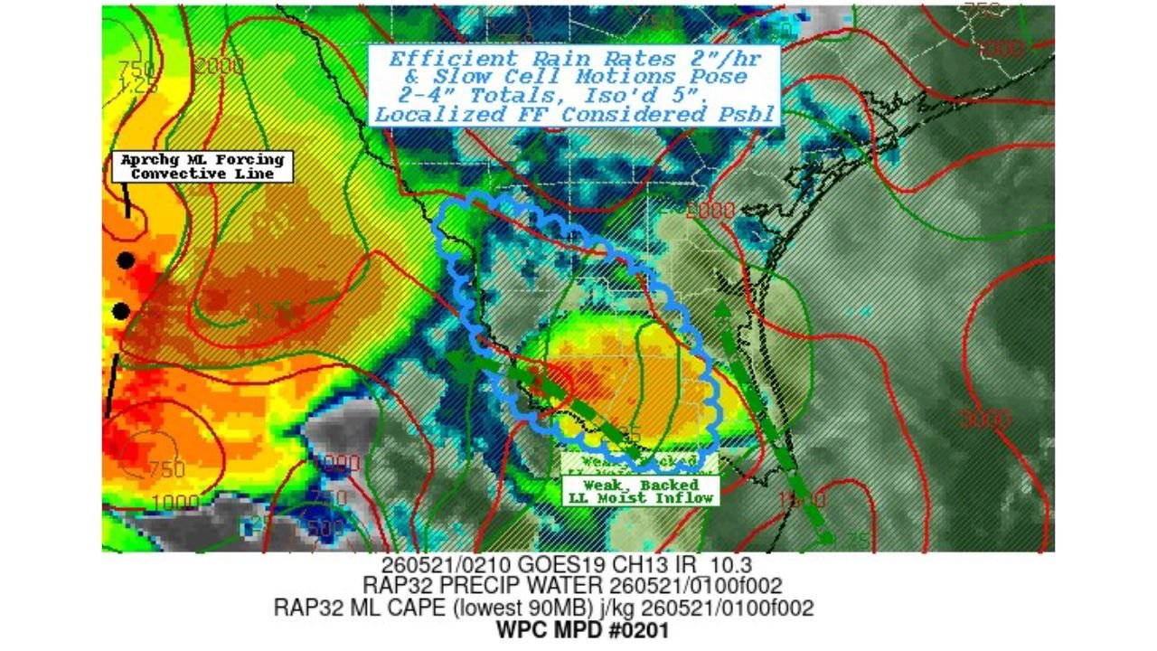
LOWER RIO GRANDE VALLEY, TEXAS — The Weather Prediction Center has issued Mesoscale Precipitation Discussion Number 0201 affecting the Lower Rio Grande Valley and Deep South Texas as of 0210Z on Wednesday, May 21, 2026. Forecasters are warning that efficient rain rates of 2 inches per hour combined with slow-moving storm cells are creating the conditions needed for 2 to 4 inch rainfall totals, with isolated locations possibly receiving up to 5 inches, making localized flash flooding a real possibility across the region.
What Is Driving This Flash Flood Threat
Two factors are combining to create a dangerous rainfall situation across Deep South Texas:
- Rain rates of 2 inches per hour from highly efficient storm cells
- Slow cell motions that allow storms to sit over the same areas for extended periods rather than moving through quickly
When storms move slowly and produce heavy rain at the same time, rainfall totals accumulate rapidly over small areas, dramatically increasing the flash flood risk for low-lying communities, drainage systems, and roadways.
The Rainfall Total Range for Deep South Texas
| Scenario | Expected Rainfall |
|---|---|
| General coverage area | 2 to 4 inches |
| Isolated highest totals | Up to 5 inches |
An Approaching Convective Line Adds to the Concern
The discussion also highlights an approaching forcing convective line moving in from the west, along with weak, backed low-level moist inflow feeding moisture into the storm complex from the south. This atmospheric setup is supporting the efficient and slow-moving storm activity currently impacting the Lower Rio Grande Valley.
Flash Flooding Is the Primary Danger
With 2 inch per hour rain rates and totals potentially reaching 5 inches in isolated locations, flash flooding is the top concern for communities across the Lower Rio Grande Valley and Deep South Texas right now. Residents should avoid low water crossings immediately, stay away from drainage channels and arroyos, and be prepared to move to higher ground quickly if water begins rising near their location.
Stay with CabarrusWeekly.com for live flash flood updates across South Texas through Wednesday.