Virginia Maryland and Washington DC to Receive 1 to 3 Inches of Drought-Busting Rain Through Sunday With Friday Delivering the Heaviest 0.5 to 1.5 Inch Totals and Mountain Flooding Possible
MID-ATLANTIC — A multi-day soaking rain event is unfolding across the Mid-Atlantic region through Sunday, May 25, 2026, with forecast totals of 1 to 3 inches expected to bring May rainfall back toward near-normal levels for a region that has been in severe drought for most of the past year. While this rain will not fully break the drought, it represents the most significant and sustained rainfall the region has seen in a long time.
What Is Fueling This Multi-Day Rain Pattern
The rainfall is being driven by a conveyor belt of moisture pushing in from the southwest and connecting with stalled fronts over the area. At the same time, high pressure to the north is directing cool and moist Atlantic Ocean air inland, keeping the region locked in a wet pattern through the holiday weekend. This dual moisture source is what is allowing rainfall to persist across multiple days rather than clearing out quickly.
A Full Day by Day Rainfall Breakdown
| Day | Conditions | Expected Rainfall |
|---|---|---|
| Tonight | Light to moderate rain developing | About 0.25 inches |
| Friday and Friday night | Moderate to heavy rain at times | 0.5 to 1.5 inches |
| Saturday and Saturday night | On and off showers, coverage uncertain | 0.25 to 1.25 inches |
| Sunday and Memorial Day | Spotty and intermittent showers | Better days for outdoor plans |
Friday is the heaviest rain day of the entire event, carrying the highest single-day totals of 0.5 to 1.5 inches across the region.
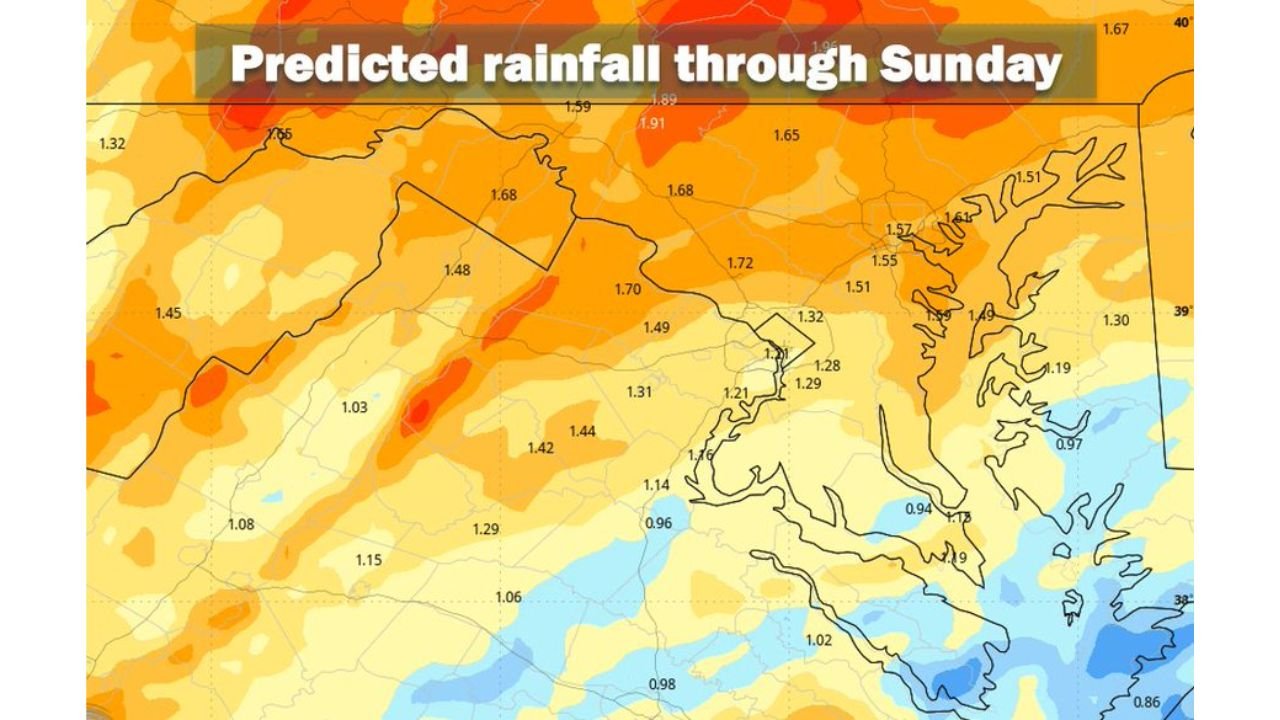
Predicted Rainfall Totals Across the Region Through Sunday
| Area | Forecast Total Through Sunday |
|---|---|
| Northwestern portions | 1.65 to 1.91 inches |
| Central and interior areas | 1.42 to 1.72 inches |
| Washington D.C. metro area | 1.20 to 1.49 inches |
| Eastern and coastal zones | 0.86 to 1.30 inches |
Mountain Areas Face Flooding Risk
Forecasters specifically call out mountain areas as locations where even heavier totals than the regional average are possible, with pockets of flooding a concern in the highest terrain. Anyone traveling through or recreating in mountain areas through Sunday should be aware of rising water in streams and creeks.
The Drought Context Makes This Rain Critical
The entire region has been deprived of significant rainfall for most of the past year, with severe drought covering the area in its entirety. Wednesday and Wednesday night already delivered a promising start with 0.5 to 1.0 inches falling along and west of Interstate 95, and the days ahead will add meaningfully to that total. While this rain will not eliminate drought conditions, it will push May rainfall back toward near-normal levels.
Sunday and Memorial Day Offer the Best Outdoor Window
Despite the multi-day wet pattern, Sunday and Memorial Day are expected to feature the most scattered and intermittent rain coverage of the entire event, making them the better days for outdoor holiday activities. Keeping plans flexible through Saturday will give residents the best chance of enjoying the holiday weekend.
Stay with CabarrusWeekly.com for daily rainfall and drought updates through the Memorial Day holiday weekend.