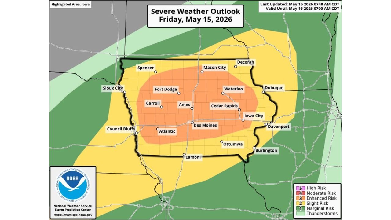
Iowa Faces an Enhanced Risk Level 3 With Hurricane-Force Winds, Very Large Hail and Embedded Tornadoes Near Des Moines, Cedar Rapids, Ames and Fort Dodge Friday May 15
DES MOINES, IOWA — The Storm Prediction Center has introduced an Enhanced Risk Level 3 out of 5 across Iowa today, Friday May 15, 2026, valid until 7:00 AM CDT Saturday May 16. Initial supercells will bring very large hail and damaging winds before quickly transitioning to a line of storms producing hurricane-force damaging winds as the system sweeps southeastward across the state. An embedded tornado or two is also possible.
Threat Zone Breakdown for Friday
Enhanced Risk core zone covering:
- Fort Dodge, Ames, Carroll, Waterloo, Cedar Rapids, Iowa City, Des Moines, and Atlantic
- This corridor faces the greatest risk of all hazards including the hurricane-force wind threat
Slight Risk surrounding zone covering:
- Sioux City, Spencer, Mason City, Decorah, Dubuque, Davenport, Burlington, and Ottumwa
Marginal Risk outer fringe:
- Extends beyond Iowa state borders into surrounding states
How the Storms Will Evolve Friday
The severe weather threat will unfold in two distinct phases:
Phase 1 Supercell Stage:
- Initial discrete supercells bring very large hail and damaging winds
- Tornado threat present during this early phase
Phase 2 Linear Stage:
- Storms quickly transition into a fast-moving line
- Hurricane-force damaging winds become the primary threat
- Embedded tornado or two still possible within the line
Kansas and the Oklahoma-Texas Panhandles Also at Risk
Farther southwest, high-based storms with a damaging wind threat are also possible from Kansas into the Oklahoma and Texas Panhandles as an additional arm of this same severe weather setup.
Stay with CabarrusWeekly.com for live updates as this Enhanced Risk severe weather event unfolds across Iowa today.