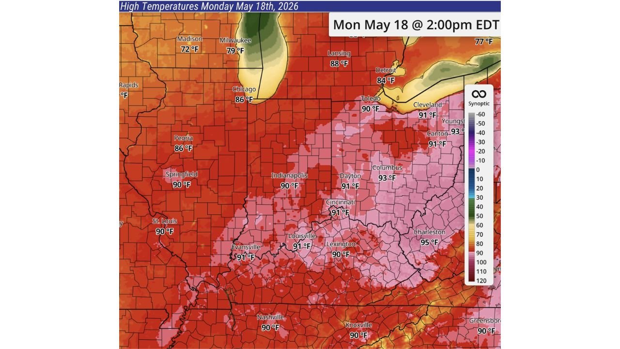
Ohio, Indiana, Illinois and West Virginia Face Possible Record Heat With Columbus at 93, Charleston at 95, Cincinnati at 91 and Indianapolis at 90 Degrees Monday May 18
OHIO — Record heat is possible across a wide stretch of the Midwest and Ohio Valley on Monday May 18, 2026, with temperatures forecast to surge well into the upper 80s to mid 90s across Ohio, Indiana, Illinois, and West Virginia by 2:00 PM EDT. Final temperatures will be highly dependent on storm timing, as early rain could limit afternoon highs, but warmer than normal conditions are expected regardless before a return to cooler and more seasonable temperatures later in the week.
Forecast High Temperatures Monday May 18
| City | Forecast High |
|---|---|
| Charleston, WV | 95°F |
| Canton, OH | 93°F |
| Columbus, OH | 93°F |
| Cleveland, OH | 91°F |
| Cincinnati, OH | 91°F |
| Dayton, OH | 91°F |
| Louisville, KY | 91°F |
| Evansville, IN | 91°F |
| Toledo, OH | 90°F |
| Indianapolis, IN | 90°F |
| Lexington, KY | 90°F |
| Springfield, IL | 90°F |
| St. Louis, MO | 90°F |
| Nashville, TN | 90°F |
| Knoxville, TN | 90°F |
| Lansing, MI | 88°F |
| Chicago, IL | 86°F |
| Peoria, IL | 86°F |
| Detroit, MI | 84°F |
| Milwaukee, WI | 79°F |
| Madison, WI | 72°F |
Storm Timing Is the Key Variable
Monday temperatures will be highly dependent on when storms arrive. If rain moves through earlier in the day, highs will be held back from their peak potential. If storms hold off until late afternoon or evening, the record heat potential becomes more realistic across the Ohio Valley and surrounding areas.
Cooler Air Returns by Mid to Late Week
Warmer than normal conditions are expected to start next week before a return to cooler and more seasonable temperatures during the second half of the week.
Stay with CabarrusWeekly.com for the latest updates on Monday heat and storm timing across the Midwest and Ohio Valley.