Kansas, Nebraska, Iowa and Wisconsin Face Damaging Winds and Very Large Hail Near Omaha, Kansas City and Des Moines as Severe Storms Stretch From Texas to Wisconsin Friday May 15 Late Afternoon and Evening
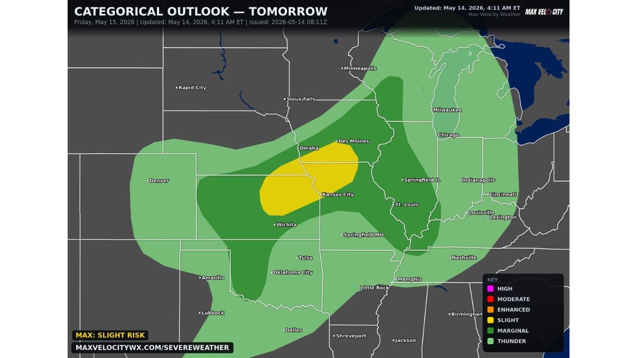
KANSAS — A large area of severe storm risk is in place for Friday May 15, 2026, stretching from Texas to Wisconsin. The categorical outlook updated at 4:11 AM ET on May 14, 2026 shows a Slight Risk centered over Omaha, Kansas City, and Des Moines, with damaging winds and very large hail as the main concerns. Storms will be most dangerous during the late afternoon and well into the evening hours.
Threat Zone Breakdown for Friday
Slight Risk core zone:
- Omaha, Kansas City, and Des Moines sit directly inside the highest risk area
- This zone carries the greatest potential for damaging winds and very large hail
Marginal Risk broader zone:
- Covers Sioux Falls, Minneapolis, Chicago, Milwaukee, St. Louis, Springfield MO, Wichita, and Tulsa
- Extends south toward Oklahoma City and Dallas
Thunder Risk outer fringe:
- Reaches east through Indianapolis, Cincinnati, Louisville, and Lexington
- Extends toward Nashville and Memphis on the southern edge
Hazards Friday Afternoon and Evening
- Damaging winds primary threat across the entire risk corridor
- Very large hail main concern especially inside the Slight Risk zone
- Most dangerous window late afternoon through evening hours
Texas to Wisconsin Corridor on Alert
The breadth of this threat zone is notable, covering a massive corridor from the southern Plains all the way through the Upper Midwest. Anyone from Wichita and Kansas City through Omaha, Des Moines, and Milwaukee should have their severe weather plan ready well before Friday afternoon.
Stay with CabarrusWeekly.com for live updates as this Friday severe storm threat develops across the Plains and Midwest.