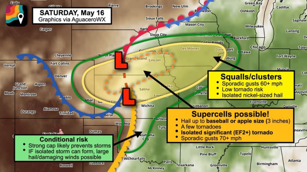
Kansas and Nebraska Face Baseball-Sized Hail, a Few Tornadoes and an Isolated EF2+ Risk Near Colby, McCook, Kearney, Hastings and Lincoln as Discrete Supercells Fire Saturday May 16
KANSAS — Saturday May 16, 2026 brings an increasing supercell risk across the Kansas-Nebraska corridor, with the greatest threat running from Colby, Kansas to near Omaha including McCook, Kearney, Hastings, and Lincoln along the I-70 to I-80 corridor. Discrete supercells capable of baseball to apple-sized hail up to 3 inches, a few tornadoes, and an isolated significant EF2 or stronger tornado are possible, along with sporadic wind gusts of 70 MPH or greater.
Two Distinct Threat Zones for Saturday
Supercell Zone covering the Kansas-Nebraska Border Corridor:
- Hail up to baseball or apple size at 3 inches
- A few tornadoes including an isolated significant EF2+ tornado
- Sporadic gusts 70 MPH or greater
- Greatest risk along and between I-70 and I-80
- Kansas-Nebraska border region is the primary supercell watch area
Squall and Cluster Zone from Kansas City to Des Moines:
- Storms expected to merge into squalls and wind clusters as they push east
- Sporadic gusts 60 MPH or greater
- Low tornado risk in this zone
- Isolated nickel-sized hail
Coverage Will Be Limited But Dangerous Where It Forms
Only about 30 to 40 percent of the area will see storms Saturday. However the lone discrete supercells that do form will have access to exceptional instability and shear, making them capable of large destructive hail and significant tornadoes.
The Tornado Wild Card Is the Low-Level Jet
The tornado potential will hinge on how quickly the low-level jet stream ramps up Saturday evening. A faster and stronger jet means more wind shear with height and a greater tornado threat. The Kansas-Nebraska border is being watched closely, especially if surface winds back to an easterly component to bolster low-level spin.
Western Oklahoma Faces a Conditional Risk Only
Farther south in western Oklahoma, a strong cap will suppress most storm formation. However if an isolated storm does manage to break through, it will be capable of large hail and damaging winds.
Stay with CabarrusWeekly.com for live updates as this Saturday supercell threat develops across Kansas and Nebraska.