Washington D.C. and Virginia Close Out 10-Day Rain Streak With Drought Still Gripping the Region as May Ends Drier Than Normal
WASHINGTON, D.C. — The Washington D.C. region’s 10-day rain streak has officially ended, with lingering showers early Friday morning extending the run to ten consecutive days before dry weather returns. Despite the prolonged stretch of rainy days, Reagan National Airport accumulated less than 2 inches over the entire period, pushing its May total to only 2.85 inches — more than 0.5 inches below normal. With no further rain expected through the end of May, the nation’s capital is on track to record its 10th drier-than-normal month out of the last 11.
Ten Days of Rain, Still Below Normal
The numbers tell a striking story. A 10-day consecutive rain streak produced less meaningful accumulation than the calendar suggests. Reagan National’s 2.85-inch monthly total falls short of normal, and the broader regional rainfall deficit over the past year sits at a significant 6 to 10 inches across much of the area. That level of long-term deficit cannot be erased by a single rainy stretch and will require multiple additional wet periods or several major rain events over the coming months to fully break the drought.
The Split: West of I-95 vs. East
Not all areas came up short. The ten-day period produced a sharp geographic split across the region:
- West of Interstate 95 received 3 to 5 inches of rain and is set to post a wetter-than-normal May
- Reagan National Airport and areas east accumulated less than 2 inches, finishing well below normal
- The rainfall west of I-95 was sufficient to reduce drought intensity from Severe to Moderate in those areas
Drought Map Shows the Damage Still Done
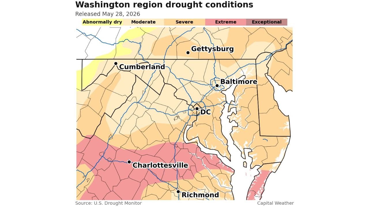
The U.S. Drought Monitor map released May 28, 2026 for the Washington region shows the drought footprint in detail:
- Washington D.C. and Baltimore remain in Moderate to Severe drought
- Gettysburg and central Maryland sit in Moderate to Severe conditions
- Charlottesville and Richmond, Virginia are shaded in Extreme drought, the deepest category on the map
- Cumberland, Maryland and far western areas show improvement toward Abnormally Dry conditions
- Coastal Delaware and eastern Maryland remain in Moderate drought
What It Will Take to Break the Drought
The math is straightforward but sobering. With a 6 to 10 inch annual rainfall deficit across much of the region, forecasters indicate the area will need either multiple extended rainy stretches or several high-rainfall storm events before meaningful drought recovery is achieved. The ten-day streak helped at the margins, particularly west of I-95, but the deeper drought categories covering Charlottesville and Richmond remain largely intact.
Dry Days Ahead Before the Next Chance
Following the end of the streak, the region is now entering several days of dry weather. This pause gives communities a brief break from the rain but does nothing to address the ongoing long-term deficit. The next significant rainfall opportunity will need to deliver far more than the last ten days combined to move the drought needle in a meaningful way.
Stay with CabarrusWeekly.com for continuing coverage of drought conditions and rainfall patterns across the Washington D.C. region.