Indiana, Ohio and Kentucky Face Heavy Rain and Lightning Tuesday Morning With Widespread Heavy Rain Returning This Afternoon and Evening Along the Low Level Jet Corridor
INDIANA — A cluster of storms with heavy rain and lightning is pushing southeast through the southern half of Indiana as of 5:00 AM EDT Tuesday, May 5, 2026, tracking toward Indianapolis, Dayton, Cincinnati and Lexington. A brief break is possible after these morning storms pass but widespread heavy rain returns this afternoon and evening across the same corridor.
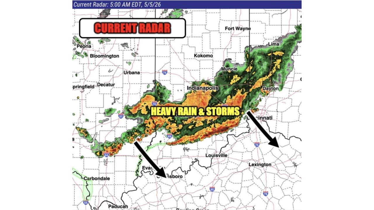
Heavy Rain and Storms Pushing Southeast Through Indiana at 5AM
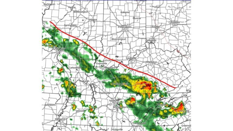
Current radar at 5:00 AM EDT Tuesday shows a solid band of heavy rain and storms stretching from Evansville northeast through Indianapolis toward Muncie, Dayton and Cincinnati. The most intense orange and red reflectivity values are concentrated along a corridor tracking through the Indianapolis to Dayton to Cincinnati axis, with the storm cluster pushing southeast rapidly through the southern half of Indiana.
A brief window of lighter rain is expected across parts of the region after this morning’s cluster pushes through, before the next round arrives.
Heavy Rain Returns This Afternoon and Evening Along the Same Zone
Simulated radar valid at 5:00 PM EDT Tuesday shows widespread heavy rain redeveloping and concentrating across a defined corridor from central Indiana through Columbus, Dayton, Cincinnati and into eastern Kentucky by the afternoon hours. A low-level jet is pumping moisture northward into the region, fueling the afternoon and evening rain threat across the same areas hit this morning.
The green circled heavy rain zone on the afternoon outlook covers:
- Indianapolis and surrounding central Indiana
- Columbus, Dayton and Cincinnati Ohio
- Louisville and Lexington Kentucky
- Evansville and surrounding southern Indiana
What Tuesday Looks Like Hour by Hour
| Period | Conditions | Area |
|---|---|---|
| 5:00 AM EDT | Heavy rain and lightning pushing southeast | Southern Indiana through Dayton and Cincinnati |
| Mid morning | Brief break possible | Parts of Indiana and Ohio |
| 5:00 PM EDT | Widespread heavy rain returns | Indiana, Ohio and Kentucky corridor |
| Evening | Continued heavy rain risk | Same corridor along low level jet |
Residents across Indiana, Ohio and Kentucky should expect a wet day with limited breaks and plan accordingly for both the morning and afternoon rounds of heavy rain.
Stay with CabarrusWeekly.com for live Tuesday rain updates across Indiana, Ohio and Kentucky through the evening hours.