The Severe Weather Pattern Is Not Done Yet: A Whole New Storm System Is Already Appearing in the Models for Friday, Targeting Oklahoma City, Wichita, Kansas City, and the Central Plains All Over Again
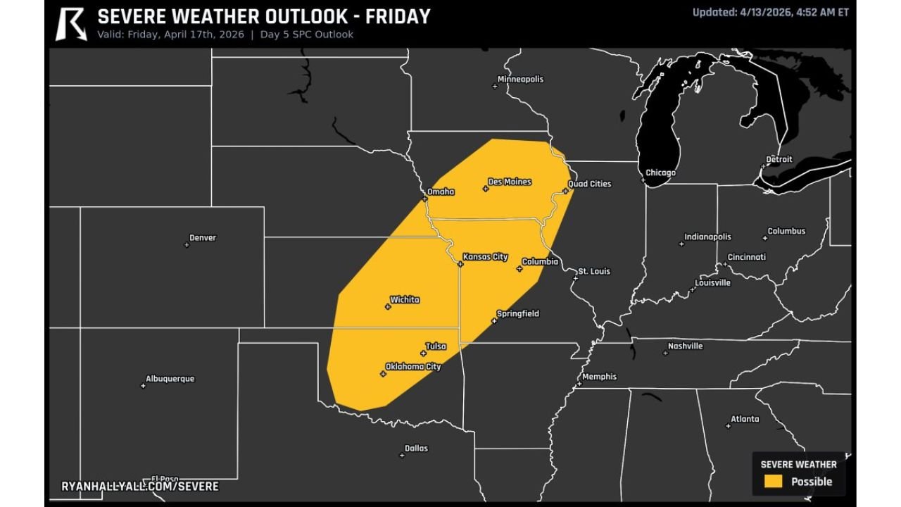
CENTRAL PLAINS, UNITED STATES — Before the current severe weather outbreak even finishes, the models are already showing what comes next. A whole other storm system is appearing in the forecast models toward Friday April 17, 2026 — and it is targeting the Central Plains corridor all over again. The SPC Day 5 Outlook, updated April 13, 2026 at 4:52 AM ET and valid for Friday April 17, 2026, has already placed a Severe Weather Possible zone over a large swath of the Plains covering Oklahoma City, Tulsa, Wichita, Kansas City, Des Moines, Omaha, and surrounding areas.
A Second System — Still Days Away but Already on the Radar
At Day 5, forecast confidence is still building — but the fact that a distinct and defined severe weather possible zone has already appeared in the SPC outlook this far out tells a meaningful story about the overall pattern. The atmosphere is not settling down after this week’s outbreak. Another organized storm system is developing in the models and targeting the same Central Plains corridor that has already faced multiple rounds of severe weather this week.
This is a pattern that bears watching closely over the next 48 hours as confidence in Friday’s setup increases and the details sharpen.
Friday’s Severe Weather Possible Zone — Who Is Included
The Day 5 SPC Outlook for Friday April 17 defines a large Severe Weather Possible zone stretching from Oklahoma and southern Kansas northeast through Missouri, Iowa, and Nebraska.
| Area | Status for Friday April 17 |
|---|---|
| Oklahoma City, Oklahoma | Inside Severe Weather Possible zone |
| Tulsa, Oklahoma | Inside Severe Weather Possible zone |
| Wichita, Kansas | Inside Severe Weather Possible zone |
| Kansas City, Missouri | Inside Severe Weather Possible zone |
| Columbia, Missouri | Inside Severe Weather Possible zone |
| Springfield, Missouri | Inside Severe Weather Possible zone |
| St. Louis, Missouri | Eastern edge of Severe Weather Possible zone |
| Des Moines, Iowa | Inside Severe Weather Possible zone |
| Omaha, Nebraska | Inside Severe Weather Possible zone |
| Quad Cities area | Inside Severe Weather Possible zone |
| Dallas, Texas | South of but near the outer edge of the zone |
| Minneapolis, Minnesota | North of the primary zone |
| Chicago, Illinois | East of the primary zone |
The zone is centered on the Kansas City, Wichita, and Des Moines corridor — the heart of the Central Plains — with the threat extending from Oklahoma City and Tulsa in the south northeast through Omaha and the Quad Cities in the north.
What a Day 5 Severe Weather Possible Zone Means
At five days out, the SPC does not issue categorical risk levels like Slight, Enhanced, or Moderate. Instead, the Severe Weather Possible designation at Day 5 indicates that the large-scale atmospheric pattern supports the potential for a severe weather event on that date. It is an early signal — not a final forecast — but it is meaningful.
A Severe Weather Possible zone at Day 5 tells forecasters and the public that:
- A storm system is evident in the models and is expected to be present in the target area on that date
- The large-scale environment appears supportive of organized severe weather development
- The risk level, specific hazards, and geographic precision will be refined significantly as Friday approaches and the Day 4, Day 3, and Day 2 outlooks are issued
- Upgrades are possible — a Severe Weather Possible zone at Day 5 can evolve into a Slight, Enhanced, or even higher risk category by the time Day 2 outlooks are issued
The Central Plains Is Being Hit Repeatedly This Week
The appearance of Friday’s system in the models is significant in the broader context of what has already been a relentless week of severe weather across the Plains and Midwest. The same corridor from Oklahoma through Kansas, Missouri, and Iowa that is highlighted in Friday’s Day 5 outlook has already faced:
- Sunday’s conditional but dangerous supercell setup across Texas and Oklahoma
- Tuesday’s Enhanced Risk severe weather day from Texas to Michigan
- Wednesday’s continued severe weather round across the Plains and Great Lakes
Friday would represent yet another round targeting the same battered corridor — a pattern that signals the overall atmospheric setup remains highly active and favorable for repeated severe weather development across the Central Plains through at least mid-April.
Cities That Need to Start Watching Friday
While it is still five days away and details will change, residents and emergency managers across the following cities should begin monitoring Friday’s forecast closely as model guidance refines over the next 48 to 72 hours:
Oklahoma and Southern Plains: Oklahoma City, Tulsa, Wichita
Missouri Corridor: Kansas City, Columbia, Springfield, St. Louis
Iowa and Nebraska: Des Moines, Omaha, Quad Cities
These are the cities sitting in the current center of the Day 5 Severe Weather Possible zone, and they are the locations most likely to see the threat refine and potentially intensify as Friday’s system comes into sharper focus in the models.
Friday Severe Weather Outlook at a Glance
| Factor | Details |
|---|---|
| Valid date | Friday April 17, 2026 |
| Outlook type | SPC Day 5 |
| Updated | April 13, 2026 at 4:52 AM ET |
| Current designation | Severe Weather Possible |
| Core threat zone | Oklahoma City, Tulsa, Wichita, Kansas City, Des Moines, Omaha |
| Zone extent | Oklahoma northeast through Missouri, Iowa, and Nebraska |
| Confidence level | Building — Day 5 details still evolving |
| Upgrade potential | Yes — risk level could increase significantly by Day 2 |
The Pattern Is Not Resting — Friday Demands Attention
The current severe weather outbreak across the Plains and Midwest is not the end of the active pattern — it may be just the beginning of a prolonged stretch of severe weather weeks. A whole other storm system is already appearing in the models for Friday April 17, and it is targeting the same Oklahoma City, Wichita, Kansas City, and Central Plains corridor that has been hit repeatedly this week.
At Day 5, the details are still coming into focus. But the signal is there, the zone is defined, and the corridor from Oklahoma to Iowa is already on notice for another potential severe weather day before the week is out.
Stay with CabarrusWeekly.com for daily updates on Friday’s developing storm system, outlook upgrades as they are issued, and ongoing severe weather coverage across the Central Plains through the end of the week.