West Texas Including Midland, Amarillo and Lubbock Face Isolated 75 MPH Dry Downburst Threat Under Level 2 Slight Risk Friday May 29
WEST TEXAS — A Level 2 out of 5 Slight Risk for severe weather is in effect across portions of western Texas on Friday, May 29, 2026, with the primary threat being an isolated dry downburst capable of winds exceeding 75 mph. Jet stream momentum aloft combined with dry surface winds accelerating downdrafts is creating the setup for this dangerous wind threat across the region.
What a Dry Downburst Is and Why It Is Dangerous
A dry downburst occurs when precipitation evaporates before reaching the ground in a dry atmosphere, but the evaporative cooling creates a dense pocket of cold air that plunges rapidly toward the surface. When this air hits the ground it spreads outward in all directions as a powerful wind burst. With jet stream momentum aloft adding additional energy to the descending air column, isolated gusts of 75 mph or greater are possible with little to no rainfall reaching the surface as a warning sign.
The Two Threat Zones
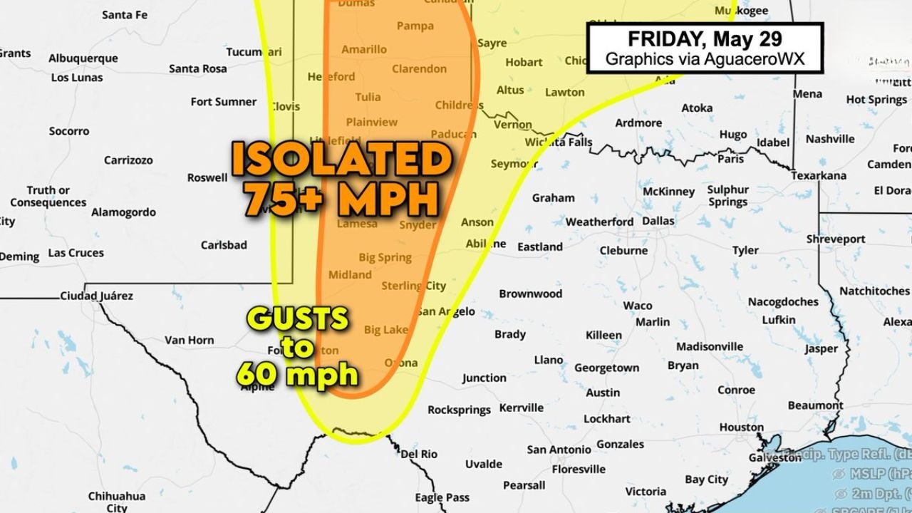
The forecast graphic for Friday, May 29 identifies two distinct wind threat areas across western Texas:
Core Orange Zone: Isolated 75+ MPH Downburst Risk The highest threat corridor runs from the Texas Panhandle southward through the South Plains and Permian Basin, covering:
- Amarillo and Pampa in the northern Panhandle
- Tulia, Plainview and Littlefield
- Lamesa, Snyder and Big Spring
- Midland and Sterling City
Outer Yellow Zone: Gusts to 60 MPH A broader surrounding area carries the risk of gusts up to 60 mph, extending the threat outward to include:
- Hereford and Clarendon
- Paducah and Vernon
- Carlsbad and the Big Lake area
- Ozona and portions of the Edwards Plateau
Why This Setup Is Producing Wind Threats
The combination of jet stream energy aloft pushing down into the lower atmosphere and dry surface conditions across west Texas creates ideal conditions for downburst amplification. In a dry environment, precipitation-driven evaporative cooling dramatically increases the density and speed of descending air. Without moisture to slow the process, these downbursts can strike suddenly and with little visible warning to residents on the ground.
What West Texas Residents Should Do Today
Anyone across the Midland, Amarillo, Lubbock and Big Spring areas should take this wind threat seriously:
- Secure any loose outdoor items that could become projectiles in 75 mph winds
- Avoid traveling in high-profile vehicles including RVs, trailers and box trucks through the risk zone today
- Be alert for sudden strong gusts even under partly cloudy or clear-looking skies
- Do not assume the absence of rain means severe weather is not occurring nearby
Stay with CabarrusWeekly.com for continuing updates as Friday’s dry downburst threat develops across western Texas.