Hen Egg to Baseball: The Strongest Storms Today Pack a Devastating Hail Threat Across Minnesota, Wisconsin, and Northern Illinois as the Significant Hail Zone Gets Manually Expanded to Capture the Full Danger
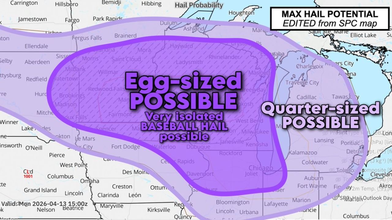
MINNESOTA, WISCONSIN, AND NORTHERN ILLINOIS — The strongest thunderstorms firing today are carrying a serious and destructive hail threat, and the risk zone has just been expanded. A manually adjusted significant hail risk zone now includes northern Illinois after forecasters determined the original SPC map did not fully capture the danger. The most robust thunderstorm updrafts today are capable of producing hail between hen egg and baseball size — and the corridor at risk stretches from the Dakotas and Minnesota south through Wisconsin and into northern Illinois and Iowa.
Why the Hail Zone Was Manually Expanded
This is not a standard off-the-shelf forecast product. The Max Hail Potential map — edited from the original SPC guidance and valid Monday April 13, 2026 at 15:00Z — was manually adjusted by forecasters to include northern Illinois based on their assessment that the official SPC zone underestimated the hail threat for that area. That kind of manual adjustment signals that the forecaster has higher confidence in the hail threat than the automated guidance alone suggests, and that northern Illinois residents need to take today’s hail risk seriously.
What Size Hail Is Possible and Where
The adjusted hail potential map identifies two overlapping zones of hail risk across the Upper Midwest and Great Lakes today.
| Hail Size | Zone Covered |
|---|---|
| Egg-sized hail | Core zone from Minnesota through Wisconsin into northern Iowa and northern Illinois |
| Very isolated baseball-sized hail | Within the egg-sized zone — most dangerous storms only |
| Quarter-sized hail | Expanding east toward Milwaukee, Kenosha, Janesville, Rockford, Chicago, Joliet, Kalamazoo, Lansing, Detroit, Fort Wayne, Toledo, Cleveland, Akron, and surrounding Great Lakes areas |
The egg-sized hail zone forms the bullseye of today’s threat, covering a large area that includes:
Minnesota: Saint Cloud, Willmar, Morris, Brainerd, Fergus Falls, Mora, Redwood Falls, Watertown, Brookings, Sioux Falls, Fairmont, Worthington, Spencer, Le Mars, Fort Dodge
Wisconsin and Iowa: Madison, Dubuque, Waterloo, Cedar Rapids, Des Moines, Davenport, Ottumwa
Northern Illinois: Rockford — now included following the manual zone adjustment
Inside that egg-sized zone, very isolated baseball-sized hail is possible from the strongest and most organized updrafts. Baseball-size hail at 2.75 inches is the upper end of what today’s atmosphere can support and represents a catastrophic hail threat for any area it affects.
The Quarter-Sized Zone — A Wider Threat Across the Great Lakes
East of the egg-sized core, a broader quarter-sized hail zone extends across a wide swath of the Upper Midwest and Great Lakes region. Cities sitting in this zone face a meaningful and damaging hail threat even if they miss the worst of the egg-sized and baseball-sized storm cores.
Quarter-sized hail zone cities include:
Wisconsin: Milwaukee, Kenosha, Janesville, Green Bay area
Illinois: Chicago, Joliet, Rockford area
Michigan: Kalamazoo, Lansing, Detroit, Pontiac, Flint, Cadillac, Traverse City, Charlevoix, Cheboygan
Ohio: Toledo, Cleveland, Akron, Columbus area
Indiana: Fort Wayne, Lafayette, Muncie, Auburn
Minnesota northern edge: Duluth, Hibbing, Houghton area
Hen Egg to Baseball — Understanding the Size Difference
The range of hail being discussed today — hen egg to baseball size — represents some of the most destructive hail the atmosphere can produce. Understanding what these sizes mean on the ground matters:
| Hail Size | Approximate Diameter | Damage Potential |
|---|---|---|
| Quarter-sized | 1.00 inch | Dents vehicles, damages crops |
| Hen egg-sized | Approximately 1.75 inches | Shatters vehicle glass, damages roofs significantly |
| Baseball-sized | 2.75 inches | Destroys vehicles, punches through roofs, life-threatening outdoors |
The most robust updrafts today — the tallest, most powerful thunderstorm cores — are the storms capable of lofting hailstones to baseball size before dropping them. These are not common occurrences. When a forecaster says baseball-size hail is possible from the strongest storms, it means the atmosphere today has the raw energy to support truly extreme hail production.
Protecting Yourself and Your Property Today
With egg-sized to isolated baseball-sized hail possible across Minnesota, Wisconsin, and northern Illinois today, and quarter-sized hail possible across a wide Great Lakes corridor, immediate action is warranted:
- Get vehicles under cover right now — a garage, carport, or covered parking structure — baseball and egg-sized hail will total an unprotected vehicle in seconds
- Stay indoors when storms approach — egg-sized and baseball-sized hail falls at speeds capable of causing serious injury and is lethal to anyone caught in the open
- Protect pets and livestock — bring animals inside or under solid shelter before storms arrive
- Move lawn furniture, outdoor equipment, and any fragile items inside — hail of this size will destroy anything left in the open
- Stay away from windows during the height of any hailstorm — baseball-sized hail can shatter glass and send debris into interior spaces
Today’s Hail Threat at a Glance
| Factor | Details |
|---|---|
| Valid time | Monday April 13, 2026 at 15:00Z |
| Map type | Max Hail Potential — manually edited from SPC guidance |
| Reason for manual edit | Northern Illinois added due to elevated local hail confidence |
| Maximum hail size possible | Baseball — very isolated, from strongest updrafts |
| Primary hail size zone | Egg-sized across Minnesota, Wisconsin, northern Iowa, northern Illinois |
| Secondary zone | Quarter-sized across Milwaukee, Chicago, Detroit, Cleveland, Fort Wayne corridor |
| Key hail size range | Hen egg to baseball |
The Hail Risk Is Real, Expanded, and Demands Action Now
The fact that forecasters manually expanded this hail zone to include northern Illinois is the clearest signal that the official guidance alone does not fully capture today’s danger. The most robust updrafts across Minnesota, Wisconsin, Iowa, and northern Illinois are capable of producing hen egg to baseball size hail today, while a wide swath of the Great Lakes from Milwaukee and Chicago east through Detroit, Toledo, Cleveland, and Fort Wayne faces the quarter-sized hail threat.
Get vehicles covered. Stay inside when storms fire. Watch the sky and have alerts active throughout the day. Today’s hail threat is significant, manually expanded, and very real across one of the most densely populated corridors in the country.
Stay with CabarrusWeekly.com for live hail reports, storm tracking, and severe weather updates across Minnesota, Wisconsin, northern Illinois, and the full Great Lakes hail threat corridor throughout the day.