Cancel Your Tuesday Night Plans: Storms Explode Across Iowa and Northwest Illinois at 4-6 PM Before Hammering Chicagoland by 7-9 PM With 75+ MPH Winds, Baseball-Size Hail, and EF-2 Tornadoes Possible Through Midnight
NORTHERN ILLINOIS — Tuesday April 14, 2026 is shaping up as one of the most dangerous severe weather evenings northern Illinois has seen in years. The cap breaks between 4 and 6 PM, storms explode across Iowa and northwest Illinois, and by 7 to 9 PM the entire Chicagoland area is in the crosshairs. The all-hazard threat runs from 5 PM straight through midnight — and the hazards on the table are not minor. Winds exceeding 75 mph, baseball-size hail, and isolated tornadoes up to EF-2 strength are all possible before these storms finally exit Illinois around or after midnight.
How Tuesday Unfolds — Hour by Hour
The morning hours on Tuesday will be relatively quiet for most of Illinois. A few storms are possible overnight into Tuesday morning, but the overall atmosphere should remain mostly dry through the afternoon as the cap holds and prevents early storm development.
That changes fast in the late afternoon. The atmosphere will rapidly destabilize and heat up through Tuesday, and when the cap finally breaks between 4 and 6 PM, the response will be explosive. Storms will fire quickly across Iowa and northwest Illinois to start the event, then organize and move east as the evening progresses.
| Time | Expected Conditions |
|---|---|
| Overnight to Tuesday morning | A few storms possible, most areas dry |
| Daytime Tuesday | Rapid destabilization and heating underway |
| 4 PM to 6 PM | Cap breaks — storms explode across Iowa and northwest Illinois |
| 7 PM to 9 PM | Storms move into Chicagoland — peak threat window |
| 9 PM to Midnight | Storms continue moving east across northern Illinois |
| Around and after Midnight | Storms exit Illinois |
The window from 5 PM through midnight is the all-hazard threat period for northern Illinois. Anyone with evening plans on Tuesday — outdoor events, travel, youth sports, anything that puts people outside or on the road — needs to have a severe weather plan and be ready to take immediate shelter.
The Hazards: All of Them Are on the Table
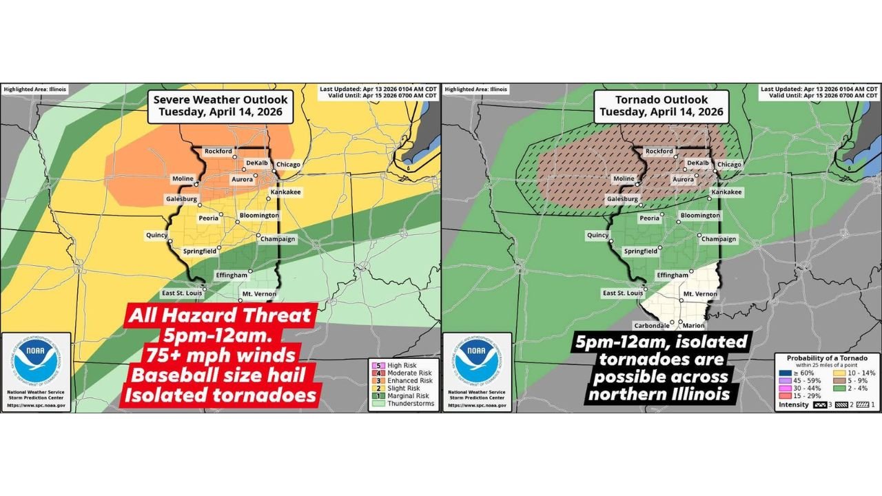
The SPC Severe Weather Outlook for Tuesday April 14, 2026, updated April 13, 2026 at 1:04 AM CDT and valid until April 15, 2026 at 7:00 AM CDT, places northern Illinois under a formal all-hazard threat from 5 PM through midnight. Every major category of severe weather hazard is in play for this event.
Damaging Winds — 75+ MPH Wind gusts exceeding 75 miles per hour are possible from the most organized storms Tuesday evening. At that speed, winds are capable of snapping large trees, downing power lines across wide areas, causing structural damage to buildings, and creating extremely dangerous conditions for anyone outdoors or on the road.
Baseball-Size Hail The storms Tuesday evening will carry enormous amounts of energy — enough to support baseball-size hail in the strongest cells. Baseball-size hail measures 2.75 inches in diameter and falls at speeds capable of shattering vehicle glass, punching through roofs, and causing serious injury to anyone caught outdoors.
Isolated Tornadoes — Up to EF-2 Strength The tornado threat is the headline hazard for northern Illinois Tuesday evening. Isolated tornadoes are possible from 5 PM through midnight, and critically, some may be strong — reaching up to EF-2 intensity. An EF-2 tornado carries winds of 111 to 135 mph and is capable of destroying well-constructed homes, uprooting large trees, and causing catastrophic damage to any structure in its path.
The Tornado Outlook — Northern Illinois Is in the Probability Zone
The NOAA NWS Storm Prediction Center Tornado Outlook for Tuesday April 14, 2026, valid until April 15, 2026 at 7:00 AM CDT, defines the tornado threat zone with precision. The highest tornado probability sits directly over northern Illinois, covering a corridor that includes the following cities:
| City | Tornado Threat Zone |
|---|---|
| Rockford | Inside tornado probability zone — 15 to 29% within 25 miles |
| DeKalb | Inside tornado probability zone |
| Moline | Inside tornado probability zone |
| Aurora | Inside tornado probability zone |
| Galesburg | Inside tornado probability zone |
| Chicago | Eastern edge of tornado probability zone |
| Kankakee | Near eastern edge of tornado probability zone |
| Peoria | Southern edge of tornado probability zone |
| Bloomington | Near probability zone |
The tornado probability within 25 miles of a point reaches the 15 to 29 percent range across the core of northern Illinois — a level that represents a meaningful and elevated tornado threat for a Tuesday evening in April. The hatching on the tornado outlook map indicates intensity concerns, meaning that any tornadoes that develop have the potential to be significant rather than brief and weak.
The Severe Weather Outlook by Risk Zone for Illinois
| Risk Level | Illinois Cities Covered |
|---|---|
| Enhanced Risk — Level 3/5 | Rockford, DeKalb, Moline, Aurora, Galesburg, Peoria, Bloomington, Champaign, Springfield, Quincy, East St. Louis, Effingham, Mt. Vernon |
| Slight Risk — Level 2/5 | Chicago, Kankakee, and surrounding northeast Illinois |
| Marginal Risk — Level 1/5 | Outer edges of the state |
The Enhanced Risk zone covers the vast majority of Illinois from the northwest corner down through the central and southern portions of the state. Chicago and the immediate northeast sit in the Slight Risk zone but remain within the all-hazard threat window as storms push east through the 7 to 9 PM timeframe.
If You Have Evening Plans in Northern Illinois — Read This
Forecasters are delivering a direct and urgent message: be prepared if you have any evening plans tomorrow. These storms will have a ton of energy, and the window from 5 PM through midnight covers the exact hours when most people are commuting home from work, sitting down for dinner, attending events, and eventually going to bed.
- Cancel or modify any outdoor plans for Tuesday evening across northern Illinois — this is not the night to be outside
- Avoid unnecessary travel between 5 PM and midnight — 75+ mph wind gusts and baseball-size hail on the road are life-threatening
- Know your tornado shelter before 5 PM — basement or interior lowest floor room away from windows — and make sure every family member knows where to go
- Do not rely on seeing the tornado — Tuesday evening storms may move through after dark, making visual confirmation of a tornado impossible
- Set phone alerts for your county now and make sure they are active for the entire overnight period through midnight
- Have a weather radio with battery backup in case power is knocked out early in the event by the wind and hail
Tuesday Evening All-Hazard Threat — Northern Illinois Summary
| Factor | Details |
|---|---|
| Valid period | Tuesday April 14, 2026 — 5 PM through Midnight |
| Outlook valid until | April 15, 2026 at 7:00 AM CDT |
| Storm initiation | 4 to 6 PM across Iowa and northwest Illinois |
| Chicagoland arrival | 7 to 9 PM |
| Exit time | Around or after midnight |
| Maximum wind gusts | 75+ mph |
| Maximum hail size | Baseball — 2.75 inches |
| Tornado potential | Isolated, up to EF-2 strength |
| Highest tornado risk cities | Rockford, DeKalb, Moline, Aurora, Galesburg, Peoria |
| Risk level | Enhanced — Level 3 of 5 across most of Illinois |
Northern Illinois — The Clock Is Already Running
The cap breaks between 4 and 6 PM Tuesday and the storms that follow will be loaded with energy. 75+ mph winds, baseball-size hail, and EF-2 capable tornadoes moving into Chicagoland by 7 to 9 PM and not exiting the state until after midnight — this is the kind of Tuesday evening severe weather event that leaves a mark.
Northern Illinois needs to be fully prepared before Tuesday afternoon arrives. The time to make your shelter plan, charge your devices, check your weather radio, and cancel your evening outdoor plans is right now — not at 4 PM when the storms are already firing.
Stay with CabarrusWeekly.com for live Tuesday severe weather coverage across northern Illinois, Chicagoland tornado warnings and storm reports, and real-time updates throughout the evening event from initiation through the midnight exit.