Northern Florida and the Panhandle Face Isolated Severe Storm Threat Thursday as Frontal Boundary Weakens Through the Afternoon
NORTHERN FLORIDA AND THE FLORIDA PANHANDLE — A small but active zone of severe weather potential remains in place across extreme northern Florida and the Florida Panhandle on Thursday, May 7, 2026, with only an isolated severe storm capable of gusty winds or a brief spin-up expected along a weakening frontal boundary. The threat is forecast to wane through the afternoon hours.
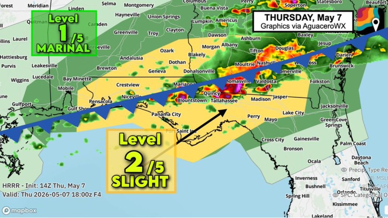
The Risk Zones for Thursday May 7
The outlook valid Thursday May 7 at 18:00Z places two risk levels across the region:
- Level 2 of 5 Slight Risk covers the Florida Panhandle corridor including Panama City, Tallahassee, Perry, and surrounding areas along the frontal boundary
- Level 1 of 5 Marginal Risk extends further north and west across southern Alabama and southern Georgia including Dothan, Marianna, Blountstown, and the surrounding region
Hazards Expected This Afternoon
Residents inside the Slight Risk zone across the Panhandle should be aware of the following isolated threats:
- Gusty damaging winds
- Brief spin-up tornado possible
The Threat Is Waning
The frontal boundary driving today’s activity is weakening as it moves through the afternoon hours. The HRRR model initialized at 14Z on May 7 and valid at 18:00Z shows storm activity concentrated along and just ahead of the boundary, with coverage expected to diminish as the front loses energy through the rest of the day.
This is not a widespread or prolonged severe weather event. Activity will remain isolated in nature with the most active window already closing as the afternoon progresses.
Communities to Watch
Residents across Panama City, Tallahassee, Perry, Blountstown, Quincy, and the surrounding northern Florida Panhandle remain in the Slight Risk zone through the valid period. Communities further north across Dothan, Marianna, and southern Georgia sit within the broader Marginal Risk area.
Stay with CabarrusWeekly.com for continuing updates on Thursday’s severe weather threat across northern Florida and the Panhandle.