Northern Utah Mountains Brace for Sloppy, High-Elevation Snow as Snow Levels Surge Toward 9,000 Feet and Heavy Rain Targets Valleys Overnight
UTAH — A strengthening winter storm is ramping up across northern Utah today and is expected to peak overnight, bringing heavy precipitation and unusually high snow levels that could push near 9,000 feet, leaving many lower elevations dealing with cold rain instead of snow.
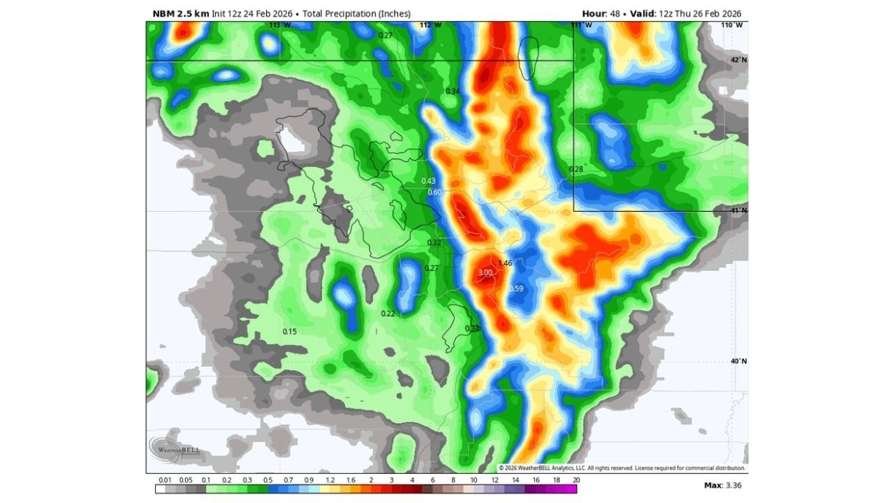
Forecast precipitation maps show a concentrated band of heavier totals aligned along the Wasatch Range, while snow level projections indicate much of the event will fall as rain below higher mountain elevations.
Heavy Precipitation Focused Along the Wasatch Range
Model guidance valid through early Thursday highlights a corridor of significant precipitation stretching north to south along the Wasatch Mountains.
Localized totals exceed 1.0 to 1.5 inches, with some embedded areas approaching or surpassing 2 to 3 inches of liquid equivalent in the higher terrain. Valley locations show lower totals, generally under an inch, but still steady rainfall.
This pattern favors mountain slopes and higher elevations, where upslope enhancement will maximize precipitation intensity overnight.
Snow Levels Climbing to Near 9,000 Feet
One of the most notable aspects of this system is the rapid rise in snow levels, projected to hover between 8,000 and 9,000 feet during the peak of the storm.
That means many mid-elevation ski bases and mountain communities could see rain or a rain-snow mix, especially during the heaviest precipitation window.
Ensemble guidance shows snow levels starting lower early in the event before climbing sharply overnight, then gradually dropping again by Thursday morning as colder air filters in.
Extra Sloppy Conditions for Mid-Elevations
With snow levels so high, much of the precipitation below roughly 8,500 feet will fall as rain, creating slushy, waterlogged snowpack conditions at higher resorts and wet roadways in mountain passes.
The mix of rain and heavy, wet snow can increase the risk of:
Heavy snow loading at upper elevations
Reduced snow quality at ski bases
Standing water and runoff issues in valleys
Travel through mountain corridors could become messy overnight, especially where rain transitions back to snow as temperatures cool later.
Peak Impacts Overnight Into Early Thursday
The storm is expected to intensify tonight and peak during the overnight hours, when precipitation rates are highest and snow levels are at their maximum.
By early Thursday morning, models suggest snow levels begin to fall back toward 6,000 to 7,000 feet, allowing accumulating snow to redevelop at mid-elevations before tapering off.
This late drop could produce a brief window of accumulating snow on passes that initially saw rain.
What This Means for North Carolina Readers
While this storm is centered over northern Utah, it highlights the complex nature of late-winter systems in the western United States, where snow levels can fluctuate dramatically within a single event.
Travelers heading to Utah’s mountain resorts should prepare for rain at base elevations and heavy, wet snow higher up, especially overnight.
If you’re in Utah experiencing this storm, share your conditions and photos with us at CabarrusWeekly.com to help keep others informed.