Severe Storm Threat Expands from Oklahoma on Wednesday into Kansas and Missouri by Friday with 15% Risk Zones Identified
OKLAHOMA — A renewed round of severe weather risk is taking shape across the southern Plains this week, with a 15% probability zone in place Wednesday across parts of Oklahoma before the threat shifts north into Kansas and Missouri by Friday, according to the latest severe weather outlook maps.
The midweek setup keeps storm chances focused across southern and eastern Oklahoma, while late-week energy spreads the same level of risk farther north into the central Plains and lower Midwest.
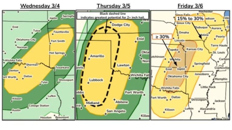
Wednesday: 15% Severe Risk Focused Across Southern and Eastern Oklahoma
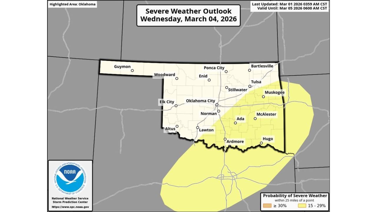
The Wednesday outlook highlights a 15–29% probability of severe weather within 25 miles of any given point across much of southern, southeastern, and east-central Oklahoma.
Cities included in the highlighted zone include:
- Ardmore
- Ada
- McAlester
- Hugo
- Muskogee
- Areas just southeast of Oklahoma City and near Norman
The risk zone stretches along and just north of the Red River and expands northeast toward the Arkansas border. While the western half of Oklahoma — including Guymon, Woodward, and Altus — remains outside the highlighted area, central and eastern counties are under closer monitoring.
A 15% severe probability typically indicates conditions favorable for scattered strong to severe thunderstorms. Hazards in these setups often include damaging wind gusts, large hail, and isolated tornado potential, depending on how storms organize later in the day.
The valid period extends into early Thursday morning, suggesting any stronger storms could continue into the overnight hours.
Friday: Same 15% Risk Shifts North into Kansas and Missouri
By Friday, the severe weather outlook shifts noticeably northward. The updated map shows a 15% severe probability corridor stretching from north-central Texas through central and eastern Oklahoma and into Kansas and Missouri.
The highlighted zone now includes:
- Portions of central and eastern Kansas
- Much of western and central Missouri
- Northern sections of Oklahoma
- A narrow extension into parts of north Texas
This northward progression signals that the storm system responsible for Wednesday’s activity is expected to lift toward the central Plains. As that happens, instability and wind shear parameters appear sufficient to support another round of strong thunderstorms.
Communities in Kansas and Missouri that were not under Wednesday’s risk zone now fall into the Friday outlook area, reinforcing the multi-day nature of this weather pattern.
Understanding the 15% Severe Probability
A 15% severe weather probability within 25 miles of a point is a meaningful signal in extended outlooks. It does not guarantee severe storms everywhere in the shaded region, but it does indicate:
- Atmospheric ingredients are expected to align
- Storm coverage may be scattered but impactful
- Some storms could reach severe limits
These types of outlooks are often upgraded or refined closer to the event depending on how upper-level energy, moisture return, and frontal boundaries evolve.
Multi-Day Pattern Suggests Ongoing Monitoring
The maps indicate a pattern shift rather than a single isolated storm day. Wednesday’s focus across Oklahoma followed by Friday’s expansion into Kansas and Missouri suggests a broader trough moving east across the Plains.
When severe risk areas shift northward like this, it typically reflects:
- A strengthening upper-level disturbance
- Expanding warm-sector instability
- Increasing wind shear across the central Plains
This setup often supports organized thunderstorm clusters or possible supercells, depending on how individual storm modes develop.
What This Means for the Central Plains
Residents across southern Oklahoma on Wednesday should stay alert for afternoon and evening storm development. By Friday, attention shifts to Kansas and Missouri, where the same 15% probability returns for a larger region.
Although no higher-tier risk categories are shown in the provided outlooks, a 15% zone still warrants attention, particularly as details become clearer within 48–72 hours of each event.
Weather conditions can evolve quickly in early March, especially when transitioning from southern Plains setups into the mid-Missouri Valley region.
If you are traveling across Oklahoma, Kansas, or Missouri later this week, it will be important to monitor updated forecasts for timing and hazard specifics.
If you are seeing changing skies or developing storms later this week, share your local conditions and updates with us at CabarrusWeekly.com so we can continue tracking how this evolving severe weather pattern unfolds.