Slight Risk of Large Hail Tornadoes and Damaging Winds Sweeps From Northern Oklahoma to Southern Minnesota Thursday April 23
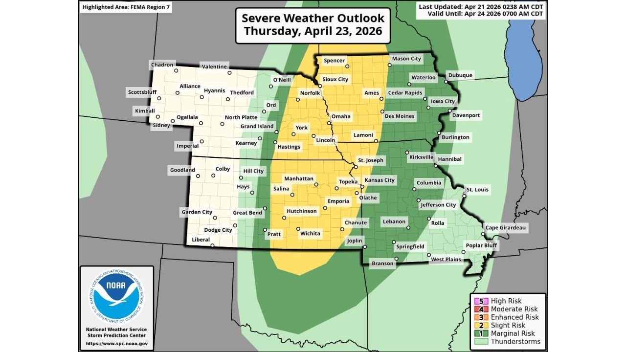
FEMA REGION 7 — The Storm Prediction Center has issued a formal severe weather outlook for Thursday April 23, 2026, with a Slight Risk — Level 2 covering a concentrated corridor from northern Oklahoma through Kansas and Nebraska into southern Minnesota, and a broader Enhanced Risk — Level 3 and Marginal Risk — Level 1 zone extending across a wide multi-state footprint from the Plains through the Missouri Valley.
Slight Risk Core Runs From Wichita Through Omaha to Sioux City
The Slight Risk zone — indicating organized and likely severe thunderstorm activity — stretches in a well-defined north-to-south corridor from Wichita, Salina, and Hutchinson in Kansas northward through Manhattan, Topeka, Lincoln, York, Hastings, Norfolk, and Sioux City. Cities including Omaha, Grand Island, and Spencer also fall within the Slight Risk footprint.
An Enhanced Risk — Level 3 area is embedded within the Slight Risk zone, concentrated across portions of central Nebraska and northern Kansas, indicating a focused zone of higher severe storm confidence within Thursday’s overall outlook.
Large to Very Large Hail, Damaging Winds and Tornadoes All Possible
Thursday’s hazard profile is broad and serious. Large to very large hail is the headline threat across the Slight and Enhanced Risk zones, with damaging winds also expected to be widespread along and ahead of the main storm line. A few tornadoes are possible, particularly with any discrete supercell activity that develops ahead of the squall line during the afternoon and evening hours.
| Risk Level | Zone | Key Cities |
|---|---|---|
| Enhanced — Level 3 | Central Nebraska, N Kansas | Grand Island, Hastings, Salina |
| Slight — Level 2 | N Oklahoma to S Minnesota | Wichita, Topeka, Lincoln, Omaha, Sioux City |
| Marginal — Level 1 | Broad surrounding zone | Kansas City, St. Louis, Des Moines, Joplin |
| Thunderstorms | Outer fringe | Cedar Rapids, Davenport, Springfield |
Marginal Risk Extends Into Kansas City, St. Louis and Des Moines
A broader Marginal Risk — Level 1 zone surrounds the core threat area, covering a large swath of the Missouri Valley and surrounding region. Cities including Kansas City, St. Joseph, Jefferson City, St. Louis, Joplin, Springfield, Columbia, and Hannibal all fall within the Marginal Risk zone — meaning isolated severe storms are possible even outside the primary Slight Risk corridor.
Outlook Valid Through April 24 at 7 AM CDT
Thursday’s severe weather outlook is valid through 7:00 AM CDT Friday April 24, meaning the storm threat extends through the overnight hours as the system pushes eastward. Residents across the affected corridor should have severe weather plans in place before Thursday afternoon and remain alert through Thursday night.
Stay with CabarrusWeekly.com for live severe weather updates across Nebraska, Kansas, Iowa, and Missouri through Thursday April 24.