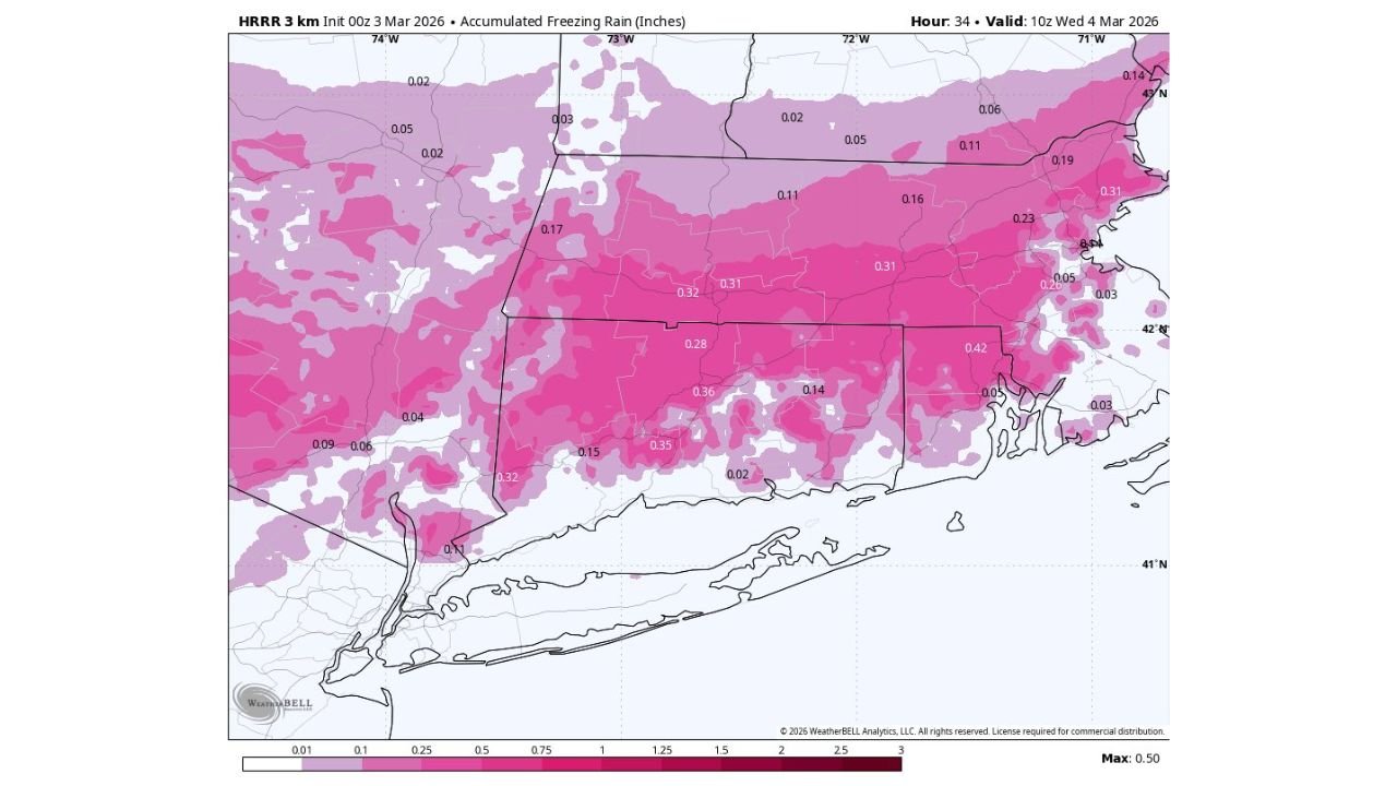
Connecticut River Valley From Bradley Airport to Hartford and Meriden Braces for Significant Freezing Rain as HRRR Trends Colder Across Connecticut and Western Massachusetts
CONNECTICUT AND WESTERN MASSACHUSETTS — A colder trend in the latest HRRR guidance is raising concern for a significant freezing rain event Wednesday morning, particularly along the Connecticut River Valley from Bradley International Airport (BDL) through Hartford and potentially southwest toward Meriden.
Updated high-resolution model projections indicate that cold air may become trapped in the valley for much of the day, increasing the likelihood of prolonged icing.
Connecticut River Valley Identified as Primary Problem Area
The most concerning corridor stretches from:
- Bradley International Airport (BDL)
- Hartford, CT
- South and southwest toward Meriden, CT
- Surrounding hill towns in central Connecticut
- Extending into portions of western Massachusetts
This region is especially vulnerable due to terrain effects that can lock cold air into the valley while warmer air rides over the top — a classic freezing rain setup.
HRRR Trends Colder, Increases Ice Accumulation Potential
The HRRR 3 km model shows accumulated freezing rain totals reaching:
- Around 0.25 to 0.35 inches across central Connecticut
- Localized totals approaching 0.40 to 0.42 inches in parts of eastern and central Connecticut
- Lower, but still impactful amounts extending into western Massachusetts
Even a quarter inch of ice can cause:
- Tree damage
- Power outages
- Hazardous travel conditions
If amounts approach or exceed one-third of an inch, scattered to numerous outages become possible.
Cold Air Damming and Valley Lock-In
The colder trend suggests cold air may remain entrenched in the Connecticut River Valley longer than previously anticipated.
Key factors include:
- Surface temperatures holding at or below freezing
- A shallow cold layer trapped by terrain
- Warmer air aloft producing freezing rain rather than snow
This setup increases the risk that icing persists for several hours instead of quickly transitioning to plain rain.
Surrounding Areas Also at Risk
While the valley appears to be the highest concern zone, icing extends across much of:
- Central and eastern Connecticut
- Portions of northern Connecticut
- Western Massachusetts
Ice totals taper somewhat farther west and south, but even lighter amounts can create dangerous road conditions.
Travel and Infrastructure Concerns
The Wednesday morning commute could be significantly impacted in:
- Hartford County
- Tolland County
- Portions of Hampden County, MA
Bridges, overpasses, and untreated secondary roads will freeze first. Power lines and tree limbs could begin to accumulate glaze if freezing rain persists through mid-morning.
What This Means for North Carolina Readers
While this storm is focused in New England, freezing rain events serve as an important reminder of how terrain and shallow cold air can dramatically impact precipitation type.
In North Carolina, similar cold air damming setups east of the Blue Ridge can produce comparable icing events during winter.
CabarrusWeekly.com will continue monitoring major winter weather developments nationwide and provide updates if similar cold-air patterns develop closer to the Carolinas.