Severe Weather Threat Expands Across Texas, Oklahoma, Arkansas, Missouri, Illinois and Indiana Through Friday With Large Hail, Damaging Winds and Tornado Risk
UNITED STATES — Several rounds of severe weather are lining up this week across the Central United States, with the threat zone stretching from Texas and Oklahoma north into Missouri, Illinois, Indiana and parts of the Lower Midwest between Wednesday and Friday.
Forecast guidance highlights three consecutive days of concern, each with the potential for large hail, damaging winds and isolated tornadoes, as storm systems track east and northeast across the Plains and Mississippi Valley.
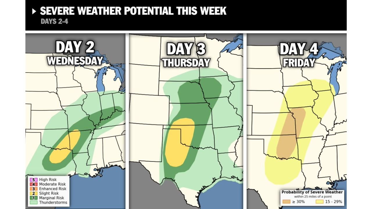
Wednesday: Southern Plains to Mid-Mississippi Valley in Focus
On Wednesday, the greatest severe weather potential is centered across:
- Central and eastern Texas
- Oklahoma
- Arkansas
- Missouri
- Parts of western Tennessee and western Kentucky
- Southern portions of Illinois and Indiana
The most concentrated corridor of stronger storms appears from north-central Texas into eastern Oklahoma and western Arkansas, where conditions could support organized thunderstorms capable of producing large hail and damaging wind gusts. An isolated tornado or two cannot be ruled out, particularly where storms remain discrete rather than forming a solid line.
Thursday: Risk Shifts North Across Oklahoma, Kansas, Missouri and Iowa
By Thursday, the severe weather zone shifts slightly north and expands across:
- Oklahoma
- Kansas
- Missouri
- Iowa
- Parts of Nebraska and Arkansas
The core of the threat includes central Oklahoma into southern Kansas and western Missouri. This setup suggests renewed development of strong to severe thunderstorms, again capable of large hail and strong wind gusts. Depending on storm structure and instability, a few tornadoes remain possible.
The broader green-shaded region indicates thunderstorms are likely across much of the central Plains, but the highlighted area shows where the stronger storms are most favored.
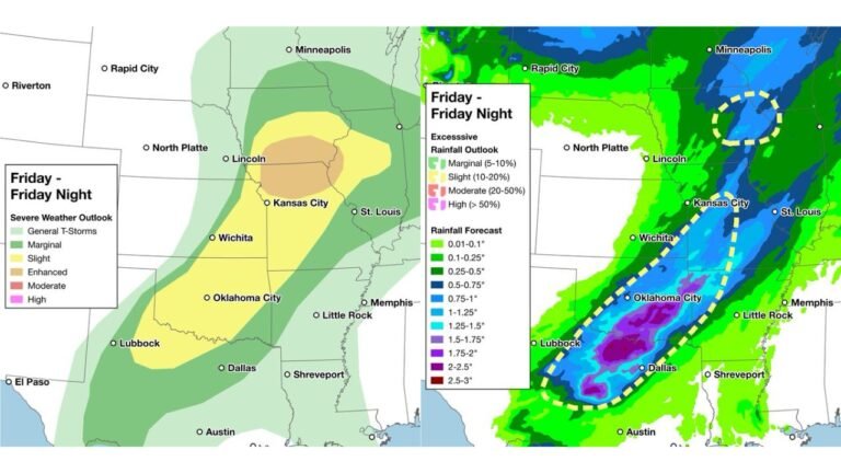
Friday: Threat Extends Into Illinois, Indiana and the Mid-South
On Friday, the severe weather risk continues eastward into:
- Illinois
- Indiana
- Missouri
- Arkansas
- Tennessee
- Possibly into parts of Kentucky
The probability zone includes a corridor from the Mid-South northward into the Lower Midwest. This suggests storms could organize along a frontal boundary, bringing another round of damaging winds and hail, with at least some tornado potential depending on how the system evolves.
What This Means
With three straight days of severe weather potential across the Central U.S., areas from Texas through the Midwest should remain alert for rapidly changing conditions.
Primary hazards include:
- Large hail
- Damaging straight-line winds
- Isolated tornadoes
- Frequent lightning and heavy rainfall
Storm timing and exact placement will likely shift as newer forecast data becomes available, but the overall pattern supports multiple rounds of active weather through the end of the workweek.
CabarrusWeekly.com will continue monitoring national weather developments and provide updates as confidence increases and impacts become clearer.