North Carolina and Upstate South Carolina Face Best Rainfall Chance in Nearly 2 Months Wednesday Night Through Thursday With 1 Inch or More Possible Across Western Mountains and Charlotte Region
CHARLOTTE, NORTH CAROLINA — The best chance of moderate to heavy rainfall in nearly two months is setting up across North Carolina and Upstate South Carolina for Wednesday night, May 6 through Thursday, May 7, 2026, with real potential for many areas to pick up at least 1 inch of rainfall as a beneficial mid-week system moves through the region.
Wednesday Is the Day to Watch for the Heaviest Rain
The excessive rainfall outlook valid for Wednesday, May 6 places a Slight risk across western North Carolina including the Asheville and Hendersonville corridor, with a 15 percent excessive rainfall probability extending into Alabama, Georgia and eastern Tennessee including Huntsville, Chattanooga and Atlanta. A 5 percent Marginal risk covers the Charlotte metro and surrounding Piedmont counties.
The outlook timeline shows:
- Monday May 4 — No Risk
- Tuesday May 5 — Marginal
- Wednesday May 6 — Slight
- Thursday May 7 — Marginal
- Friday May 8 — No Risk
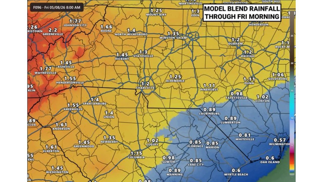
Rainfall Totals Forecast Through Friday Morning
Model blend guidance through Friday, May 8 at 8:00 AM shows rainfall totals across the Charlotte region and surrounding counties:
| City or Area | Forecast Total |
|---|---|
| Charlotte | 1.20 inches |
| Huntersville | 1.25 inches |
| Concord | 1.25 inches |
| Statesville | 1.30 inches |
| Hickory | 1.45 inches |
| Albemarle | 1.25 inches |
| Salisbury | 1.20 inches |
| Gastonia | 1.25 inches |
| Rock Hill SC | 1.25 inches |
| Asheville | 1.77 inches |
| Boone | 1.66 inches |
| Winston Salem | 1.35 inches |
| Raleigh | 1.20 inches |
Western Mountains and Upstate Carry the Highest Totals
The highest rainfall totals through Friday morning are concentrated across the western mountains and Upstate region. Areas around Asheville, Waynesville, Johnson City and Greeneville are forecast to see 1.77 to 2.20 inches, making these areas the jackpot zone for this beneficial rainfall event.
Coastal areas from Wilmington to Myrtle Beach will see lighter totals in the 0.57 to 0.85 inch range as the heavier rainfall stays focused on the western and central portions of the state.
Some Uncertainty Remains on Exact Amounts
While the overall signal for beneficial rainfall is clear, some uncertainty remains on exact totals given the system is still a few days out. The amounts shown represent the current blend of model guidance. Some areas may see more, others less, depending on storm timing and track as Wednesday approaches.
The highest chances of reaching or exceeding 1 inch remain across the western mountains, Upstate and lower east portions of North Carolina.
Stay with CabarrusWeekly.com for daily rainfall forecast updates across the Charlotte region and North Carolina through the mid-week system.