Southeast Georgia and Southeast South Carolina Face Scattered Showers Saturday With Widespread Rain and Storms Sunday Night Through Monday and Up to 2.49 Inches Through May 11
SOUTHEAST GEORGIA AND SOUTHEAST SOUTH CAROLINA — Scattered showers are moving into southeast Georgia tonight before reaching southeast South Carolina by daybreak Saturday, May 9, 2026. A multi-day precipitation event is taking shape through Monday May 11, with forecast totals ranging from 0.75 to 1.5 inches across most of the region and isolated amounts reaching 2.49 inches across the southernmost portions of the forecast area.
Three-Day Timeline of Events
Saturday May 9 Showers and a few daytime storms are expected across southeast Georgia and southeast South Carolina as the initial wave of moisture moves through the region during the day.
Sunday Night Through Monday May 11 The more significant precipitation event arrives with widespread rain and storms ahead of a cold front pushing through the region. This is where the bulk of the rainfall totals will accumulate across both states.
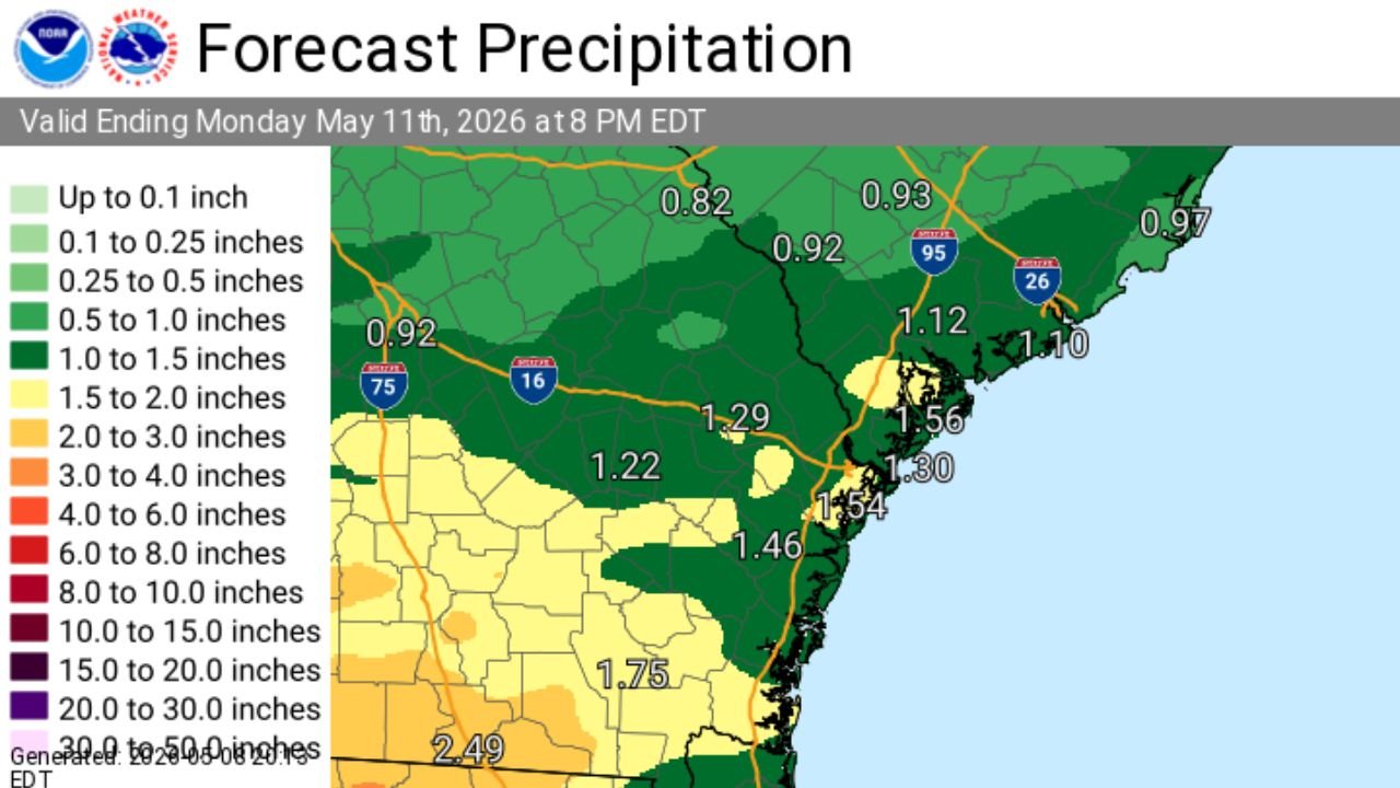
Forecast Precipitation Totals Through Monday May 11 at 8 PM EDT
The forecast precipitation map valid ending Monday May 11 at 8:00 PM EDT shows the following totals across the region:
| Location | Forecast Total |
|---|---|
| Southernmost Georgia near the Florida border | 2.49 inches |
| South Georgia corridor | 1.75 inches |
| Central coastal South Carolina | 1.54 to 1.56 inches |
| Southeast South Carolina coast | 1.29 to 1.46 inches |
| Northern coastal South Carolina | 1.10 to 1.30 inches |
| Inland Southeast Georgia | 1.22 inches |
| Northern portions of the region | 0.82 to 0.97 inches |
What Residents Should Expect
The combination of Saturday showers and the more organized Sunday night through Monday rain and storm event will produce 0.75 to 1.5 inches of total rainfall for most communities across southeast Georgia and southeast South Carolina through Monday evening. Areas in the far south near the Georgia and Florida border face the highest totals approaching 2.49 inches.
The primary concern with the Sunday night through Monday event will be locally heavy rainfall rates ahead of the cold front, with any embedded stronger storms capable of producing gusty winds and frequent lightning.
Stay with CabarrusWeekly.com for continuing updates on the weekend and Monday rain and storm threat across southeast Georgia and southeast South Carolina.