3 Straight Days of Severe Weather Outlined Wednesday Through Friday From the High Plains to the Ozarks
UNITED STATES — The Storm Prediction Center has now issued severe weather outlooks for three consecutive days — Wednesday April 22, Thursday April 23, and Friday April 24 — as a powerful storm system drives eastward across the country, delivering a relentless multi-day severe weather sequence from the central High Plains all the way through the ArkLaTex and Ozarks region.
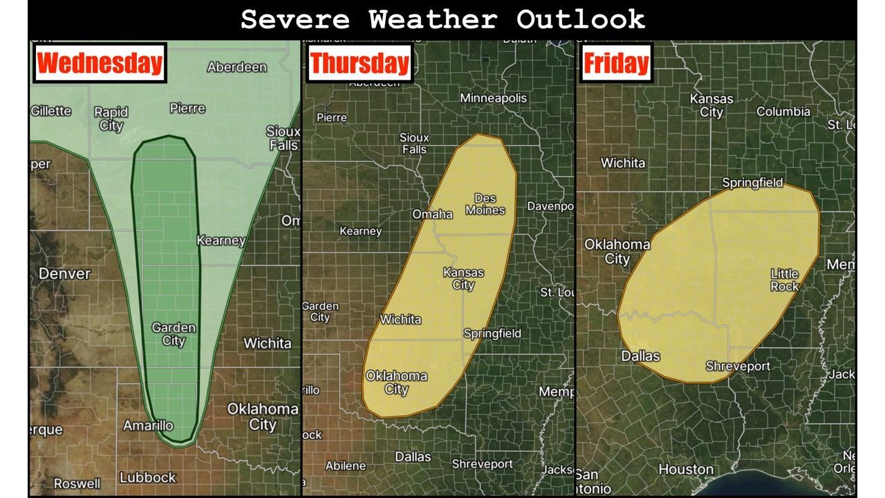
Wednesday April 22 — Hail and Wind Threat Along the High Plains Dryline
Wednesday’s severe weather risk is the most focused and limited of the three-day stretch, with a narrow north-to-south risk corridor positioned along the central High Plains dryline from Rapid City and Pierre southward through Garden City, Amarillo, and Lubbock. Troughing beginning to overspread the dryline will fire storm development, but with moisture return still in its early stages, coverage may be limited.
Should storms develop Wednesday, the primary threats are large hail and damaging winds. Tornado potential on Wednesday is lower given the early-stage moisture return.
Thursday April 23 — All Hazards Possible From Minnesota to Oklahoma City
Thursday represents the most significant and widespread day of the three-day outbreak. A larger and more expansive risk zone covers a corridor from Minneapolis and Des Moines southward through Kansas City, Wichita, and Oklahoma City, with stronger flow aloft overspreading the dryline and cold front driving a potentially widespread severe weather day.
All hazards are explicitly possible on Thursday — tornadoes, large hail, and damaging winds — across the full length of the risk corridor. This is the day requiring the highest level of alertness across the Plains and lower Midwest.
Friday April 24 — Threat Shifts to ArkLaTex and the Ozarks
As the front continues eastward, Friday’s severe weather focus shifts into the ArkLaTex region and northeastward into the Ozarks. Friday’s risk zone covers Oklahoma City, Little Rock, Shreveport, Springfield, and the surrounding region, with the threat corridor positioned across Arkansas, eastern Oklahoma, and portions of Missouri.
| Day | Risk Zone | Primary Cities | Main Hazards |
|---|---|---|---|
| Wednesday Apr 22 | Central High Plains dryline | Amarillo, Garden City, Lubbock | Large hail, damaging winds |
| Thursday Apr 23 | Minnesota to Southern Plains | Minneapolis, Kansas City, OKC, Wichita | All hazards — tornadoes possible |
| Friday Apr 24 | ArkLaTex to Ozarks | Little Rock, Shreveport, Springfield | All hazards |
Threat May Continue Through the Weekend Into Early Next Week
The severe weather pattern does not end with Friday. Medium-range guidance suggests the severe threat may persist through the weekend and into early next week as the storm system continues tracking eastward from the Southern Plains into the Southeast. The full duration and intensity of the extended severe weather period will become clearer as the week progresses.
Residents from the High Plains through the Southern Plains, Midwest, and Mid-South should have severe weather plans in place before Wednesday and remain on alert through the entire stretch.
Stay with CabarrusWeekly.com for live severe weather outlook updates across the Plains, Midwest, and Mid-South through the weekend.