Texas Panhandle, Western Oklahoma and Southern Kansas Brace for Tornadoes, 2-Inch Hail and 75 MPH Winds as Thursday Supercells Erupt
TEXAS, OKLAHOMA & KANSAS — A dangerous round of severe weather is expected to ignite Thursday afternoon and evening across the Texas Panhandle, then surge northeast into western Oklahoma and southern Kansas, with tornadoes, destructive hail and damaging winds all on the table.
Forecast guidance highlights a concentrated corridor from Lubbock and Amarillo, Texas, through Childress, Elk City and Oklahoma City, Oklahoma, extending toward Wichita, Kansas.
Tornado Risk Focused from Amarillo to Oklahoma City
Tornado probabilities are elevated across:
- Amarillo, TX
- Childress, TX
- Elk City, OK
- Woodward, OK
- Oklahoma City, OK
- Wichita Falls, TX
The highest tornado concentration appears centered near the Texas–Oklahoma border region, where atmospheric conditions favor rotating supercells.
Forecast indicators show a TORCON level 4 near Amarillo, with level 3 surrounding areas including Lubbock and western Oklahoma. A few tornadoes are expected, and stronger tornadoes cannot be ruled out where storms remain discrete.
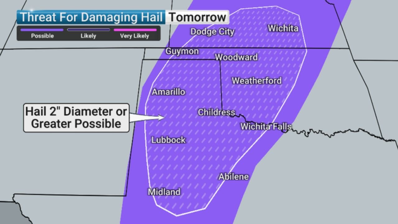
2-Inch or Larger Hail Possible
Large hail is expected to be a major concern.
Areas under the highest hail threat include:
- Lubbock
- Amarillo
- Childress
- Weatherford, OK
- Wichita Falls
- Portions of western Oklahoma into southern Kansas
Hail up to 2 inches in diameter or greater is possible, capable of causing significant vehicle and property damage.
Damaging Winds Over 75 MPH
The damaging wind corridor stretches from:
- Lubbock and Jayton, TX
- Through Childress and Elk City
- Toward Oklahoma City and Enid
- Northeast into Wichita and Emporia, KS
Wind gusts over 75 mph are possible, especially if storms begin to cluster and transition into a fast-moving line.
These winds could down trees, power lines and cause structural damage.
Storm Timeline
- Afternoon: Storms begin developing across the Texas Panhandle
- Evening: Supercells intensify and track into western Oklahoma
- Late Evening/Night: Storms push into southern Kansas
The most intense phase appears likely during the late afternoon through mid-evening hours.
Primary Threat Breakdown
Residents in the highlighted corridor should prepare for:
- Tornadoes
- Very large hail (2″+)
- Hurricane-force wind gusts up to 75 mph
- Rapid storm intensification
The most volatile environment is expected across the Texas Panhandle into western Oklahoma, where overlapping instability and wind shear create favorable conditions for rotating storms.
CabarrusWeekly.com will continue monitoring developments as this severe weather setup unfolds. Residents in the affected states should stay weather-aware and be ready to act quickly if warnings are issued.