Missouri and Illinois Brace for Another Tornado Round Tuesday as SPC Issues Enhanced Risk After Multi-Day Outbreak
MISSOURI & ILLINOIS — Just days after a multi-day tornado outbreak swept across parts of the central United States, another round of severe weather is already lining up for Tuesday.
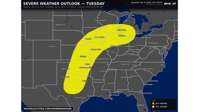
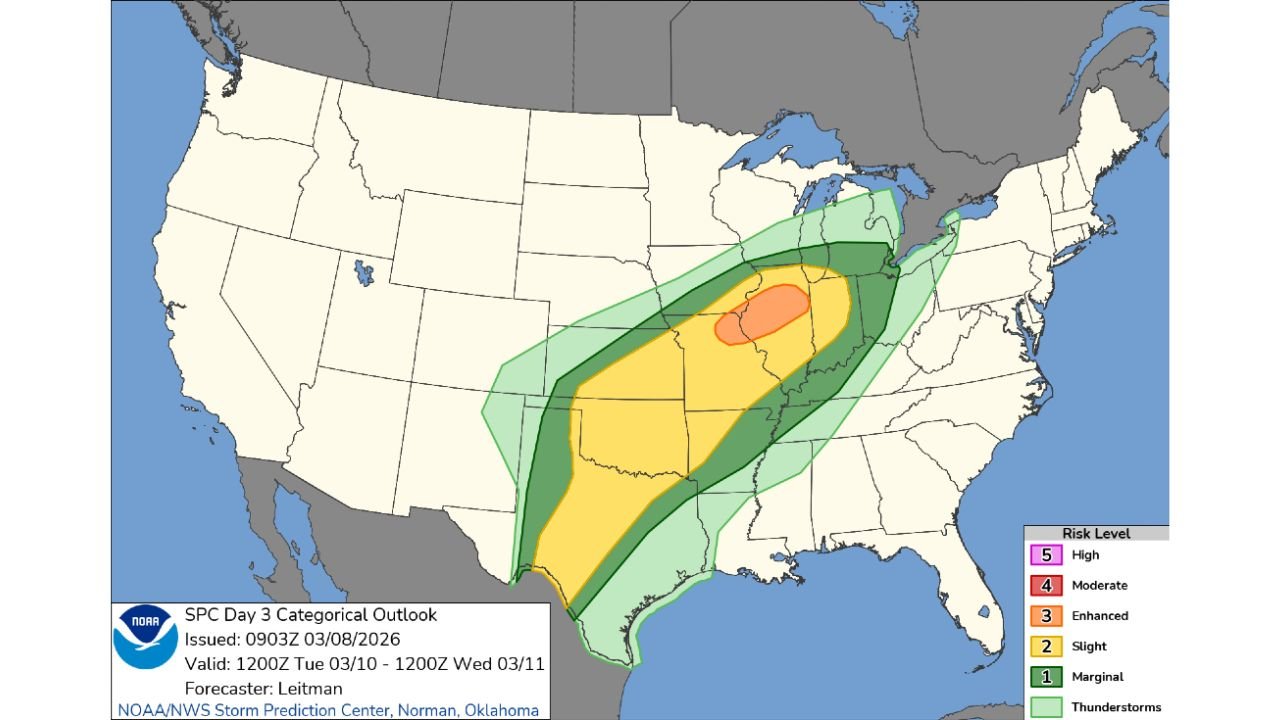
The Storm Prediction Center (SPC) has issued an Enhanced Risk (Level 3 of 5) stretching from portions of Missouri into Illinois, signaling the potential for significant severe weather, including tornadoes, very large hail, and damaging winds that could continue well after sunset.
Enhanced Risk Focused from Missouri into Illinois
The latest Day 3 categorical outlook shows a broad severe weather corridor extending from Texas northeastward through Oklahoma, Arkansas, Missouri, Illinois, Indiana, and into parts of Michigan and Ohio.
However, the most concentrated concern lies across:
- Central and eastern Missouri
- Western and central Illinois
Within this corridor, the Enhanced Risk zone highlights an area where storm intensity and coverage may be greater, and where tornado potential is more pronounced.
All Severe Hazards on the Table
According to the outlook, all severe hazards are possible Tuesday, including:
- Tornadoes
- Very large hail
- Damaging straight-line winds
The setup suggests an environment supportive of strong instability combined with favorable wind shear — ingredients that can allow storms to rotate and organize.
Forecasters are also emphasizing that storms could remain active into the evening and nighttime hours, increasing the risk for after-dark severe weather.
A Setup That Raises Concern
The broader severe weather zone (Slight Risk and higher) arcs from South Texas through the Ozarks and into the Midwest. This elongated risk area often signals a strong springtime storm system organizing over the Plains and tracking northeast.
The Enhanced Risk core over Missouri and Illinois suggests:
- Greater storm coverage
- Increased potential for organized supercells
- A higher probability of tornado-producing storms
The presence of an Enhanced Risk so soon after a recent outbreak is drawing particular attention, as the atmosphere appears primed for another active severe weather day.
Timing: Tuesday Afternoon into Night
Current projections indicate the main severe window will likely begin Tuesday afternoon across Missouri, spreading into Illinois and surrounding states through the evening.
Storms may persist well after dark, which can complicate warnings and response efforts. Nighttime tornadoes historically pose increased danger because they are harder to see and more likely to catch people off guard.
Broader Impact Zone
While Missouri and Illinois sit at the center of the Enhanced Risk, surrounding states within the broader risk area include:
- Texas
- Oklahoma
- Arkansas
- Indiana
- Michigan
- Ohio
Residents across this entire corridor should monitor updated forecasts as refinements to the risk areas are likely over the next 24–48 hours.
Bottom Line
Another round of potentially significant severe weather is expected Tuesday, with Missouri and Illinois in the bullseye for tornadoes, very large hail, and damaging winds. The SPC’s Enhanced Risk designation underscores the potential for organized, impactful storms — possibly lasting into the nighttime hours.
CabarrusWeekly.com will continue tracking updates as forecasters refine the threat.