Shallow Arctic Air Drives High-End Ice and Snow Threat Across North Texas as Major Winter Storm Targets Friday and Saturday
UNITED STATES — A major winter storm is increasingly likely across North Texas late Friday through Saturday, with forecast confidence growing in a dangerous combination of freezing rain, ice accumulation, and snow as very cold Arctic air surges southward into the region.
Why This Winter Storm Is Becoming High Impact
Forecast guidance continues to support a classic high-risk winter setup, where cold surface air arrives quickly while moisture remains abundant. This favors freezing rain over a large area, a precipitation type that often causes greater damage than snow, especially when paired with rapidly falling temperatures.
Meteorologists stress that exact totals remain uncertain, but the overall pattern strongly supports a disruptive event, not a marginal one.
Friday Starts Wet Before a Rapid Freeze Friday Night
Most of North Texas is expected to see rain develop Friday, but conditions change quickly by Friday night as surface temperatures drop below freezing. Rain is forecast to transition to freezing rain, opening the door to widespread ice accumulation.
Even modest ice amounts can lead to downed trees, damaged power lines, and extremely hazardous roads, particularly on bridges and elevated surfaces.
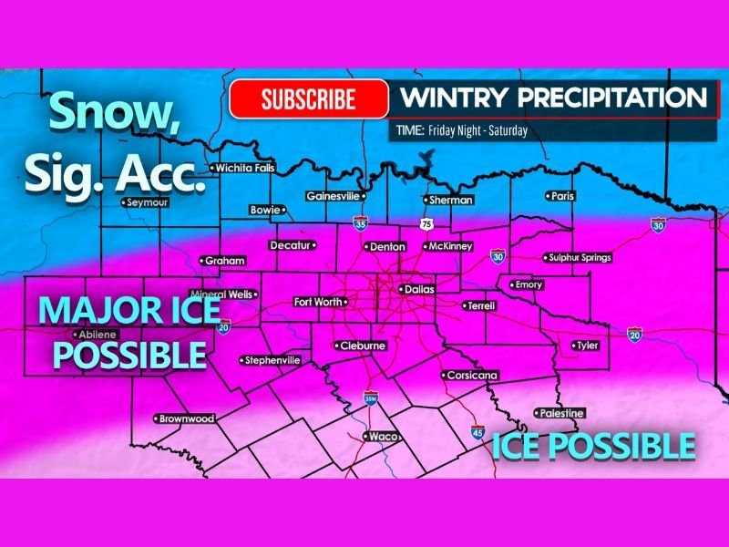
Ice Takes Center Stage Saturday Across North Texas
By Saturday, freezing rain may persist across much of North Texas, especially in the Dallas–Fort Worth Metroplex and surrounding counties. At the same time, snow continues near the Red River, where colder air is deeper and more supportive of snowfall.
The overlap of ice, snow, and plunging temperatures significantly raises the risk for prolonged power outages and impassable travel conditions.
Snow Potential Near the Red River
Areas closer to the Red River stand the best chance of seeing meaningful snowfall, which may continue into Saturday before tapering off late in the day. While snow brings its own hazards, ice accumulation farther south remains the primary concern due to its destructive potential.
Arctic Air Deepens the Danger
Behind the storm, very cold Arctic air pours into the region Saturday, locking temperatures below freezing and preventing any quick improvement. This means ice that forms is likely to remain in place, worsening travel conditions and extending impacts beyond the initial precipitation.
Power Outages and Travel Impacts Increasingly Likely
With ice accumulation possible over a broad area, power outages are firmly on the table, especially if ice builds on trees and power infrastructure. Roads may become extremely hazardous or impassable, and officials may advise avoiding travel during the height of the storm.
What Still Needs Refinement
While confidence is high in a disruptive winter weather event, exact snowfall and ice totals and the precise placement of the heaviest impacts will become clearer closer to the storm. Small temperature changes could shift the line between snow, sleet, freezing rain, and cold rain.
Now Is the Time to Prepare
Residents across North Texas are encouraged to begin basic preparations now, especially related to travel plans, power needs, and safety considerations. Final decisions should be made once forecasts become more precise, but the current signal strongly supports planning for a high-impact winter storm.
Conditions will continue to evolve, and updates will be critical as the event approaches. If you’re seeing changes in your area or preparing for the storm, share your experience and stay informed with ongoing coverage at CabarrusWeekly.com.