Southeast Iowa, Central & Northern Illinois and Northwest Indiana Face Growing Concern for Strong (EF3+) Tornado Potential Tuesday as Backed Winds and 3,000+ CAPE Align Near Warm Front
INDIANA — Concern is increasing for parts of southeast Iowa, central and northern Illinois, and northwest Indiana on Tuesday, March 10, as a potentially dangerous severe weather setup begins to take shape near a warm front draped across the region.
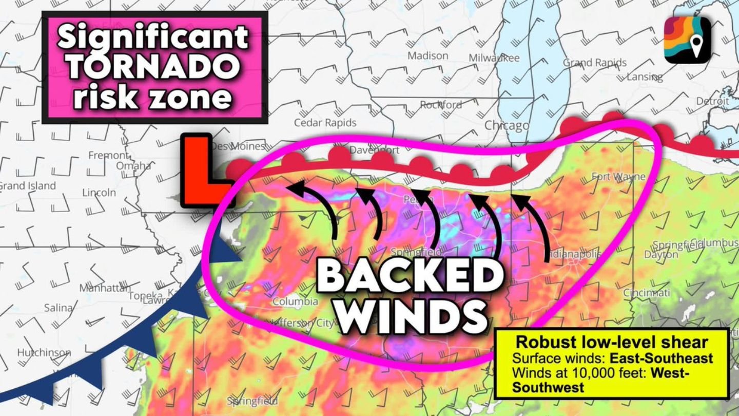
Forecast analysis points to a corridor from near Cedar Rapids and Davenport, Iowa, east through Peoria and Springfield, Illinois, and into northwest Indiana near Fort Wayne, where the ingredients for significant severe weather may overlap.
Tornado Parameter Raising Alarms
Meteorologists are flagging elevated tornado parameters in this zone — especially near and just south of the warm front.
If discrete supercells can become established in this environment, the setup could support:
- A few tornadoes
- Large, potentially tennis ball-sized hail
- The possibility of a strong (EF3+) tornado
The greatest concern appears focused along the warm front boundary, where wind fields and instability are expected to be most favorable for rotating storms.
Backed Surface Winds Increase Rotation Potential
One of the most notable features in this setup is the presence of backed surface winds.
At ground level, winds are forecast to blow from the east-southeast. However, just 10,000 feet above the surface, winds shift dramatically to the west-southwest.
That sharp directional change in the lowest two miles of the atmosphere creates:
- Robust low-level wind shear
- Increased storm-relative helicity
- Enhanced rotation potential in supercells
This type of wind profile strongly favors storms that can rotate efficiently — particularly those rooted near the warm front where shear is maximized.
Explosive Storm Fuel for Early March
Adding to the concern, forecast models are projecting up to 3,000 units of storm fuel (CAPE) across portions of the region.
For early March, that level of instability is highly unusual.
Historical comparisons suggest that CAPE values over 3,000 J/kg typically do not appear in this area until early May. Seeing this magnitude of instability 40 to 50 days earlier than average underscores how volatile the atmosphere may become Tuesday afternoon and evening.
Such high instability supports:
- Rapid storm growth
- Strong updrafts
- Enhanced hail production
- Greater tornado potential when combined with shear
Areas to Watch Closely
The zone of greatest concern currently includes:
- Southeast Iowa, including areas near Cedar Rapids and Davenport
- Central Illinois, including Peoria and Springfield
- Northern Illinois
- Northwest Indiana, including areas near Fort Wayne
Communities along and just south of the warm front should monitor forecast updates closely, as small shifts in that boundary could significantly alter where the highest tornado risk develops.
Timing and Storm Mode
Storms are expected to develop Tuesday afternoon and continue into the evening hours.
If storms remain discrete supercells before transitioning into lines, the tornado and large hail risk would be maximized during that earlier phase.
Later storm evolution into clusters or lines could shift the focus more toward damaging winds.
Bottom Line
A concerning early-March severe weather setup is taking shape across southeast Iowa, central and northern Illinois, and northwest Indiana. Backed surface winds, strong low-level shear, and unusually high instability for this time of year may create an environment supportive of significant severe storms — including the possibility of strong tornadoes near the warm front.
CabarrusWeekly.com will continue to monitor forecast updates as confidence increases and details on timing and storm placement become clearer.