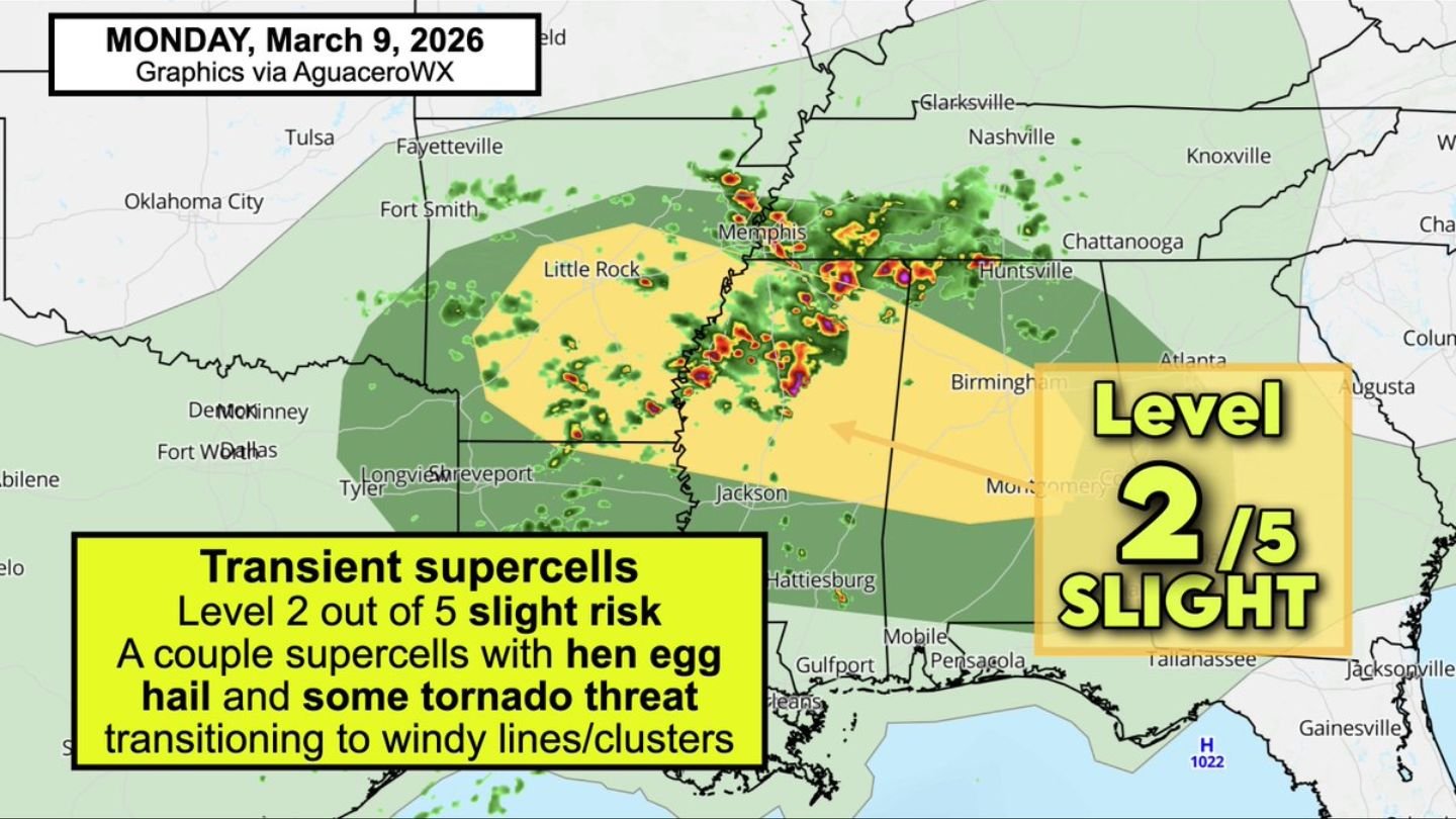
Level 2 Slight Risk Spreads Across Arkansas, Mississippi and Alabama as Tennis Ball-Size Hail Threat Builds Monday
ALABAMA — A Level 2 out of 5 “Slight Risk” for severe weather is in place Monday, March 9, covering much of Arkansas and extending into northern and central Mississippi and Alabama.
A warm front lifting north is drawing in warm, humid air, increasing atmospheric instability — the fuel thunderstorms need to intensify. At the same time, winds aloft are strengthening beneath a belt of westerly mid-level flow, creating a setup favorable for organized storms.
Where the Risk Is Focused
The highlighted severe corridor stretches from:
- Little Rock, AR
- Memphis, TN
- Jackson, MS
- Birmingham, AL
- Huntsville, AL
- Montgomery, AL
Cities near the center of the risk zone include:
- Little Rock
- Memphis
- Jackson
- Birmingham
The Slight Risk zone (Level 2 of 5) covers a broad swath from central Arkansas into central and northern Mississippi and Alabama.
Primary Threat: Large, Damaging Hail
The main hazard Monday will be large hail, potentially reaching up to tennis ball size with the strongest storms. Forecasters also note hail may appear jagged or spiky in structure, a sign of strong updrafts within rotating storms.
Initial development may feature transient supercells capable of producing:
- Hen egg to tennis ball size hail
- Isolated tornado potential
As storms evolve, some may transition into clusters or line segments, increasing the potential for gusty winds.
Tornado Risk: Isolated but Present
While hail is the dominant concern, an isolated tornado cannot be ruled out.
The tornado threat appears greatest near:
- Jackson, MS
- Birmingham, AL
- Areas between Memphis and Huntsville
Any tornado risk will likely be tied to storms that can briefly remain organized before merging into larger clusters.
Storm Evolution: Supercells to Windy Lines
Early in the event, storms may take on a supercellular structure, especially in areas with stronger wind shear. However, as the day progresses, these storms are expected to consolidate into:
- Windy lines
- Storm clusters
This shift could increase the coverage of damaging wind gusts across parts of Mississippi and Alabama.
Atmospheric Setup
Key ingredients contributing to the severe setup include:
- Northward-moving warm front
- Increasing low-level moisture
- Building instability
- Strengthening winds with height
These factors combined will help intensify thunderstorms as they develop.
Bottom Line
A Level 2 Slight Risk for severe weather covers much of Arkansas and parts of northern and central Mississippi and Alabama Monday. The primary threat is large, damaging hail — potentially up to tennis ball size — with a limited but real isolated tornado risk. Storms may begin as supercells before transitioning into wind-driven lines or clusters later in the day.
CabarrusWeekly.com will continue monitoring this developing severe weather setup as it unfolds.