Deep South and Ohio Valley on Alert as Strong Tornado Threat Returns Across Louisiana, Mississippi, Alabama, Georgia and Into West Virginia and Pennsylvania
UNITED STATES — A renewed strong tornado threat is unfolding today across parts of the Deep South and extending northeast into the Ohio Valley and central Appalachians, with forecasters warning that a few tornadoes are possible — and at least one could become strong.
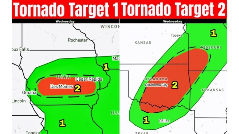
The latest tornado outlook highlights two primary corridors of concern: one stretching across the Gulf Coast states and another arcing from the Tennessee Valley into portions of West Virginia, Virginia and Pennsylvania.
Southern Corridor: Louisiana to Georgia in the Crosshairs
The first highlighted zone includes:
- Eastern Texas
- Louisiana
- Mississippi
- Alabama
- Western and central Georgia
- The Florida Panhandle
Within this region, atmospheric conditions appear supportive of rotating thunderstorms capable of producing tornadoes. Wind shear profiles suggest organized storm structures are possible, especially during the afternoon and early evening hours.
Forecasters caution that if a tornado develops in this environment, a strong tornado cannot be ruled out.
Northern Corridor: Tennessee Valley Into the Mid-Atlantic
A second area of concern extends from:
- Tennessee
- Kentucky
- Southern Indiana
- West Virginia
- Western Virginia
- Central and western Pennsylvania
This zone also shows enhanced tornado probabilities, particularly across portions of West Virginia and western Pennsylvania.
The setup suggests that discrete or semi-discrete storms may develop ahead of a larger line of storms, increasing the risk for rotating supercells before storms congeal into a squall line.
Timing: Afternoon Into Early Evening
The greatest tornado potential is expected from mid-afternoon through the early evening hours.
Key factors include:
- Increasing daytime instability
- Strong low-level wind shear
- Adequate moisture return across the Southeast and Ohio Valley
Storms that form during peak heating will have the greatest opportunity to intensify.
What “Strong Tornado” Means
A strong tornado typically refers to EF2 intensity or higher on the Enhanced Fujita scale. These tornadoes are capable of causing considerable structural damage, uprooting trees and producing dangerous flying debris.
While not every storm will produce a tornado, the environment is supportive enough that residents in the highlighted areas should remain particularly alert.
Why This Setup Is Concerning
The overlapping ingredients of instability and wind shear across two separate regions increase the geographic footprint of risk.
Unlike isolated marginal days, today’s configuration supports the possibility of:
- Multiple tornado reports
- Organized severe thunderstorms
- Damaging straight-line winds
- Isolated large hail
The fact that the threat spans both the Deep South and extends into the Ohio Valley underscores the broader-scale dynamics at play.
Bottom Line
From Louisiana and Mississippi through Alabama and Georgia — and northeast into West Virginia and Pennsylvania — conditions are favorable for tornado development this afternoon and evening.
A few tornadoes are possible, and if one forms, it could become strong.
Residents in the highlighted areas should ensure they have multiple ways to receive warnings and remain weather aware through the evening hours.
CabarrusWeekly.com will continue monitoring developments as this severe weather threat evolves.