California, Mexico, Hawaii and Central Pacific See Expanding +1°C to +3°C Sea Surface Anomalies as East Pacific Warm Tongue Signals Developing El Niño Pattern
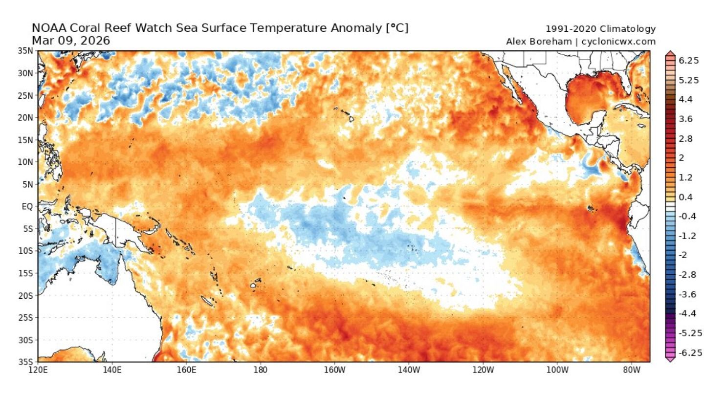
UNITED STATES — A broad and strengthening band of warmer-than-average ocean water is spreading across the eastern and central Pacific, signaling the early stages of what could become a developing El Niño pattern over the coming year.
Sea surface temperature anomaly data from early March show a pronounced “warm tongue” extending westward from the coast of South America toward the central Pacific — a classic precursor feature associated with El Niño development.
Warm Anomalies Expanding Across the Eastern Pacific
The strongest positive temperature anomalies are currently concentrated:
- Off the coasts of Peru and Ecuador
- Westward toward 120°W and 140°W longitude
- Across portions of the central equatorial Pacific
- Near Baja California and western Mexico
- In waters surrounding Hawaii
Large areas are running +1°C to +3°C above average, with some localized pockets exceeding that threshold.
This expanding zone of warmth along the equator is one of the defining structural elements of El Niño formation.
15-Day Changes Show Rapid Warming
Short-term anomaly change maps indicate continued warming in parts of the east-central Pacific over the past two weeks.
While cooler patches remain scattered across portions of the western and southwestern Pacific, the eastern basin is showing a consolidating warm signal — especially near the equator.
The persistence and growth of this feature suggest the ocean-atmosphere system may be transitioning toward a more sustained warm phase.
What the “Warm Tongue” Means
The equatorial Pacific warm tongue is a key indicator monitored by climate scientists. During El Niño development:
- Trade winds weaken
- Warm water shifts eastward
- Surface temperatures rise across the Niño regions
The current configuration shows an eastward extension of above-normal sea surface temperatures, consistent with the early structural stages of El Niño.
If this warming continues and strengthens over the next several months, it could officially meet El Niño thresholds later this year.
Potential Long-Term Impacts
El Niño events can significantly influence global weather patterns, including:
- Wetter conditions across parts of the southern United States
- Drier conditions in portions of the western Pacific
- Shifts in tropical cyclone activity
- Changes to winter storm tracks in North America
While it is still early, the growing warm anomalies suggest this is a pattern to watch closely heading into late 2026 and beyond.
Bottom Line
Sea surface temperature data show a strengthening and expanding warm anomaly across the eastern and central Pacific, forming a classic warm tongue structure often associated with developing El Niño events.
If the current warming trend continues, this feature may grow and persist into the coming year, shaping global weather patterns in the months ahead.
CabarrusWeekly.com will continue monitoring ocean temperature trends as the Pacific climate signal evolves.