Arkansas, Mississippi, Tennessee, Louisiana and East Texas Targeted Sunday Before Virginia, North Carolina and the Mid-Atlantic Face Monday Severe Weather Threat as Powerful Trough Sweeps East
UNITED STATES — Any brief lull in severe weather appears short-lived. Forecast models are converging on a powerful upper-level trough ejecting into the central United States this weekend, setting the stage for renewed severe thunderstorm development from the Mid-South on Sunday into the Mid-Atlantic by Monday.
The evolving setup shows a dynamic storm system interacting with returning Gulf moisture — a classic early spring configuration capable of producing organized severe weather.
Sunday: Mid-South and Gulf States in Focus
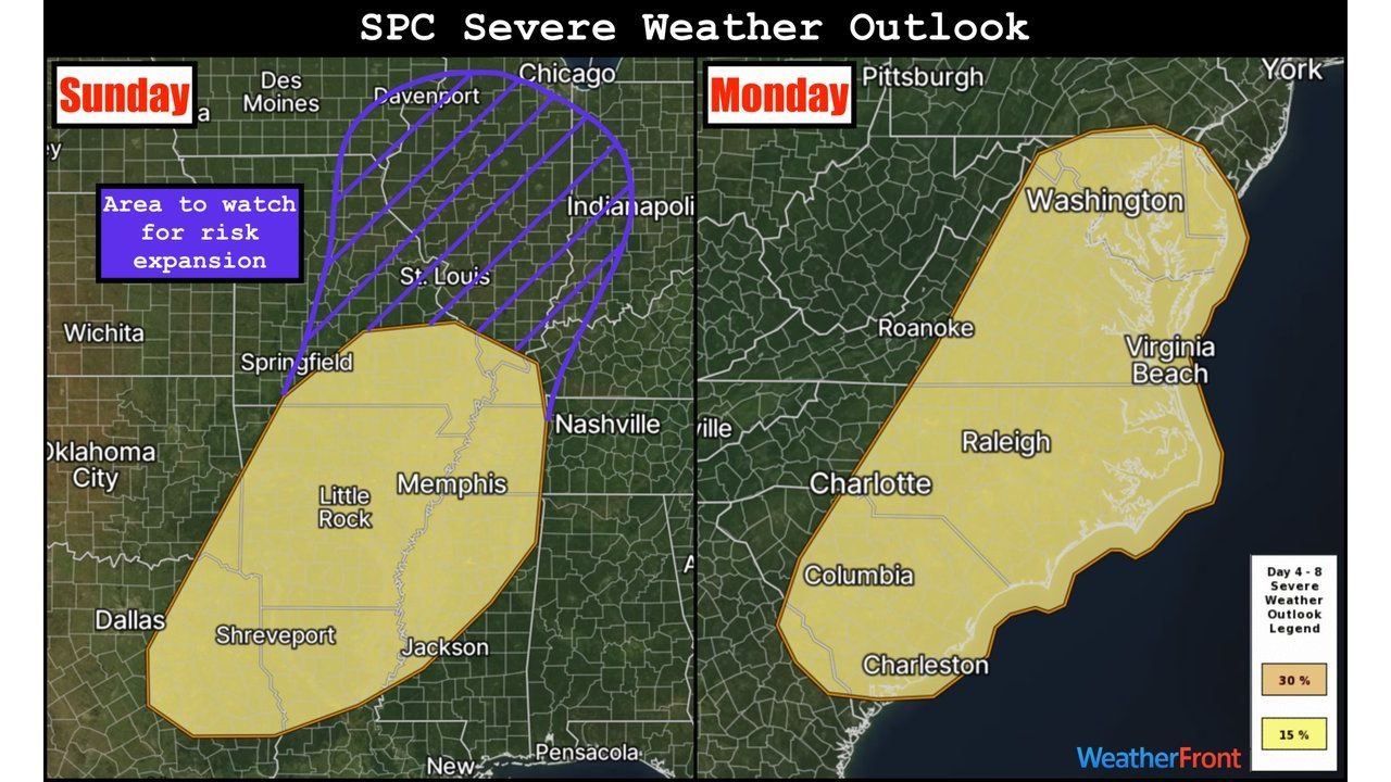
The Storm Prediction Center has outlined a severe weather risk area for Sunday, March 15, centered on:
- Arkansas
- Mississippi
- Western Tennessee
- Northern Louisiana
- East Texas
Cities within or near the outlined zone include Little Rock, Memphis, Jackson, Shreveport, and parts of the ArkLaMiss region.
Forecast ensemble data shows:
- A strong 500mb trough digging into the Plains
- Increasing wind fields aloft
- Surface dewpoints climbing into the upper 50s and low 60s across parts of the Deep South
The richest moisture appears confined to the Gulf Coast and Mid-South region, which is why Sunday’s risk area is focused there for now.
However, forecasters note that if instability trends increase farther north — especially closer to the surface low — the risk area could expand northward in future outlooks.
Midwest “Watch Area” for Possible Expansion
Model guidance suggests more limited moisture across parts of the Midwest, including:
- Missouri
- Southern Illinois
- Indiana
Still, there is a highlighted area to watch for potential risk expansion. If sufficient instability overlaps with the strong wind fields near the advancing low, portions of the Midwest could see upgraded risk levels in later forecasts.
Monday: Mid-Atlantic and Carolinas Enter the Threat Zone
As the system progresses east, the severe weather risk shifts into the Mid-Atlantic on Monday, March 16.
The outlined area includes:
- Virginia
- North Carolina
- Portions of South Carolina
- Areas near Washington, D.C.
- Eastern North Carolina including Raleigh
- Coastal sections near Virginia Beach and Charleston
Forecast dewpoint maps show 50s and low 60s advancing northward into the Carolinas and southern Virginia, indicating sufficient moisture for thunderstorm development.
At the same time, strong upper-level winds associated with the trough will overspread the region, creating a favorable environment for organized storms.
Why This Setup Matters
The combination of:
- A strong upper trough
- Increasing Gulf moisture
- Strengthening wind shear
- Advancing surface boundaries
Creates a classic early-spring severe weather pattern.
Sunday’s focus appears concentrated across the Mid-South and Gulf states, while Monday shifts the concern eastward into the Carolinas and Mid-Atlantic.
What This Means Going Forward
While exact storm modes and intensity details will be refined in the coming days, the broader signal is clear:
- Severe weather potential returns Sunday in the South.
- The threat migrates east into the Mid-Atlantic by Monday.
- Risk areas may expand depending on moisture and instability trends.
CabarrusWeekly.com will continue monitoring updates to the Storm Prediction Center outlooks as the weekend system approaches and model clarity improves.