Florida Peninsula From Jacksonville to Tampa and Ocala Braces for Thursday Squall Line as Storms Push Southeast Toward Orlando and Miami
FLORIDA — A line of storms is expected to push into and through the Florida Peninsula today, bringing periods of heavy rain, lightning and gusty winds from Jacksonville south toward Tampa, Orlando and eventually South Florida.
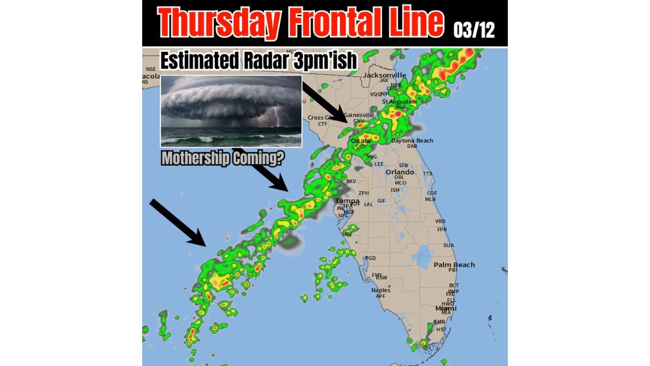
Latest short-range model guidance shows a classic squall line structure sliding southeast across the state during the afternoon hours, with radar projections centered around the 3 p.m. timeframe.
North Florida First: Jacksonville to Gainesville
The leading edge of the line is forecast to affect areas near:
- Jacksonville
- St. Augustine
- Gainesville
- Cross City
Storms in this region could produce frequent lightning, brief heavy downpours and locally gusty winds. While widespread severe weather is not strongly indicated, isolated stronger cells cannot be ruled out.
Forecasters are watching for the potential of a pronounced shelf cloud or “wall cloud” appearance along the leading edge — sometimes referred to informally as a “mothership” look when the structure becomes dramatic.
Central Florida: Ocala, Tampa and Orlando in the Path
As the line progresses southeast, it is projected to move across:
- Ocala
- The Tampa Bay area
- Orlando
- Daytona Beach
The orientation of the line suggests storms will sweep from northwest to southeast, likely moving quickly.
Residents may notice:
- A sudden increase in wind ahead of the rain
- A dramatic cloud formation along the leading edge
- Intense but short-lived downpours
Given the forward motion, storms are expected to move through fairly efficiently rather than stall over any one location.
South Florida: Showers Trail Behind
Behind the main squall line, scattered showers and embedded thunderstorms may continue across portions of:
- Naples
- Fort Myers
- Miami
These areas are more likely to experience lighter, more fragmented activity compared to the more organized band farther north.
Severe Threat Appears Limited — But Lightning Likely
Current indications do not strongly suggest widespread severe storms. However, even non-severe squall lines can produce:
- Wind gusts strong enough to knock down small branches
- Frequent lightning
- Brief visibility reductions in heavy rain
Thunder and lightning will likely be the most widespread hazards with this system.
What to Expect This Afternoon
If model projections hold, the line will be most active during mid-to-late afternoon as it pushes southeast across the peninsula.
Residents from Jacksonville through Gainesville, Ocala, Tampa and Orlando should monitor local radar and be prepared for rapidly changing conditions.
Bottom Line
A classic Thursday squall line is forecast to sweep southeast across Florida today, affecting Jacksonville, Gainesville, Ocala, Tampa and Orlando before continuing toward South Florida.
While widespread severe weather is not currently expected, gusty winds, lightning and brief heavy rain are likely.
CabarrusWeekly.com will continue monitoring radar trends and provide updates if stronger cells develop along the line.