North Carolina, Virginia, Pennsylvania & New Jersey Under Widespread Severe Storm Threat as Damaging Winds and Embedded Tornadoes Target the Southeast and Mid-Atlantic
NORTH CAROLINA — A widespread severe weather threat is taking shape for Monday across the Eastern United States, with North Carolina, Virginia, Pennsylvania and New Jersey positioned in a corridor where damaging winds and embedded tornadoes appear increasingly likely.
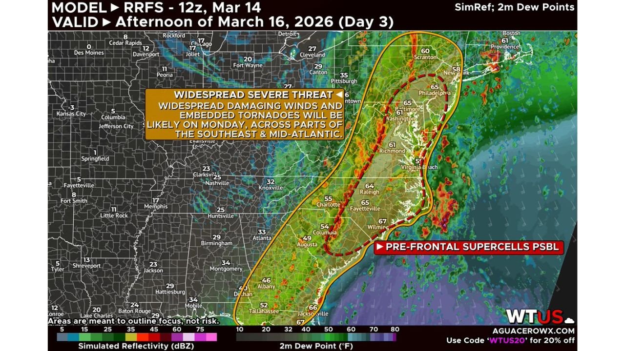
Forecasters indicate that, much like Sunday’s setup, a line of organized storms along a strong cold front will be the primary concern. This squall line is expected to move quickly eastward, capable of producing widespread wind damage and brief tornado spin-ups.
Morning Storms in the Southeast, Intensifying into the Mid-Atlantic
Severe storms may already be ongoing early Monday morning across portions of the Southeast. As the system shifts east, the line is expected to reorganize and strengthen by mid- to late morning as it moves off the lee of the Appalachians and into the Mid-Atlantic.
This phase could be critical.
If the line becomes more consolidated and accelerates, it would likely enhance the damaging wind threat from the Carolinas into Virginia, Maryland, Pennsylvania and southern New Jersey.
North Carolina in the Main Corridor
Model guidance highlights North Carolina — including areas from Charlotte and Raleigh east toward Wilmington — squarely within the broader severe zone.
For Cabarrus County and surrounding communities, the main concern appears to be:
- Damaging straight-line winds
- Embedded tornadoes within the squall line
- Brief but intense rainfall bursts
Dew points in the 60s across eastern North Carolina suggest a moist and unstable air mass ahead of the front, which can support strong storm development if instability is sufficient.
Conditional Tornado Risk from the Carolinas to New Jersey
In addition to the main squall line, there is a conditional threat for pre-frontal supercells from the Carolinas northward into Pennsylvania and New Jersey.
This threat depends on several key factors:
- A slower-moving front that does not quickly sweep the warm sector away
- Enough instability and lift for storms to mature
- A sufficiently open warm sector not disrupted by earlier storms
If those ingredients align, isolated supercells ahead of the line could produce a few stronger tornadoes. However, forecasters currently express lower confidence in this higher-end scenario.
Virginia, Maryland and Pennsylvania Also at Risk
Cities including Richmond, Washington, Baltimore, Philadelphia and areas surrounding Scranton are within the outlined severe zone.
If the squall line maintains organization, wind damage could be scattered and locally significant across the Mid-Atlantic. Embedded circulations within the line may produce quick-hitting tornadoes that develop with limited warning.
What This Means for North Carolina
For residents across Cabarrus County and central North Carolina:
- Expect storms to move quickly
- Damaging winds may be the most widespread hazard
- Tornado warnings, if issued, could involve fast-moving embedded rotations
Because squall lines often produce rapid changes in weather conditions, it will be important to monitor alerts throughout Monday, especially during the late morning and afternoon hours.
Bottom Line
North Carolina, Virginia, Pennsylvania and New Jersey are facing a widespread severe weather threat Monday, driven by an organized squall line capable of damaging winds and embedded tornadoes.
While a higher-end supercell tornado threat remains conditional, the primary risk of wind damage appears increasingly likely across the Southeast and Mid-Atlantic.
CabarrusWeekly.com will continue to monitor forecast updates and timing adjustments as Monday’s system approaches. Residents are encouraged to review safety plans and stay alert for watches and warnings as conditions evolve.