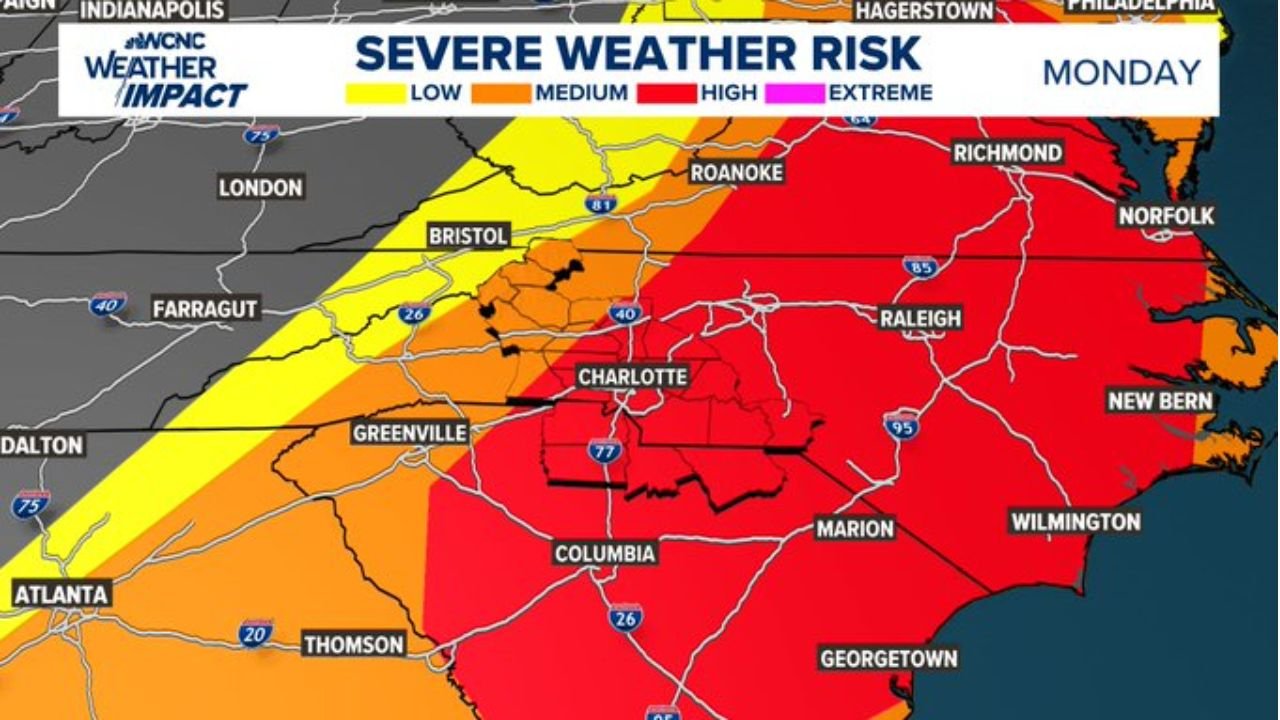
North Carolina and South Carolina Facing High Severe Weather Risk Late Sunday into Monday as Damaging Winds and Tornado Threat Target Charlotte, Raleigh and Columbia
NORTH CAROLINA — A significant severe weather setup is unfolding across the Carolinas late Sunday into Monday, with multiple waves of storms expected and a primary window of concern centered on Monday morning through mid-afternoon.
Forecasters stress that this will not be a simple “one line and done” event. Instead, rounds of storms are expected as a warm front lifts north Sunday night followed by a powerful cold front sweeping through Monday.
Sunday Night: Isolated Cells Begin the Threat
The risk begins at a lower level Sunday night as isolated storms develop along an advancing warm front.
During this phase, impacts are expected to be limited, but a few stronger cells could develop as moisture increases across the region.
Areas including Charlotte, Columbia, Greenville and parts of the western Carolinas may see scattered activity overnight.
Monday Morning Through Mid-Afternoon: Primary Window of Concern
The main severe threat ramps up Monday morning and continues into the afternoon as a strong cold front moves across North Carolina and South Carolina.
This is the period when storms are expected to become more organized and intense.
Locations in the highest concern zone include:
- Charlotte and surrounding Piedmont communities
- Raleigh and central North Carolina
- Wilmington and coastal North Carolina
- Columbia and much of central South Carolina
A broad high-risk zone covers much of central and eastern North Carolina on Monday, with strong winds highlighted as the primary hazard.
Primary Threat: Damaging Straight-Line Winds
The ingredients for severe weather are coming together:
- Strong wind shear
- Sufficient instability
- A powerful cold front acting as a trigger
The primary impact is expected to be damaging straight-line winds, rated as a high-impact hazard.
Wind gusts capable of downing trees and power lines are possible, especially within organized storm segments.
Secondary Threats: Isolated Tornadoes and Hail
While damaging winds are the main concern, isolated tornadoes remain possible — particularly if discrete cells develop ahead of the main line.
Hail is also listed as a medium-impact threat.
Flooding currently remains a lower-end concern compared to wind and tornado potential.
Not Over Until the Front Clears
The threat is expected to continue until the main front fully pushes through sometime Monday afternoon.
Storm intensity and placement will depend on how quickly instability builds and whether early storms disrupt the atmosphere before the main line arrives.
What Residents in the Carolinas Should Do
With overnight storms possible and the primary threat arriving Monday morning:
- Have at least three ways to receive weather warnings
- Ensure Wireless Emergency Alerts are enabled on mobile devices
- Charge phones and backup batteries
- Identify your safe shelter location in advance
Overnight and early morning severe weather can be particularly dangerous due to reduced awareness.
Bottom Line
North Carolina and South Carolina face a significant severe weather threat from late Sunday into Monday, with the greatest risk centered on damaging winds and isolated tornadoes during the Monday morning to mid-afternoon window.
Charlotte, Raleigh, Columbia and Wilmington are all within areas highlighted for higher impacts.
CabarrusWeekly.com will continue monitoring forecast updates and provide new information as timing and severity details become clearer. Stay weather-aware and prepared.