North Carolina, South Carolina, Virginia, Maryland and Washington DC Under Moderate Risk as Strong Tornado Outbreak Threat Expands Monday
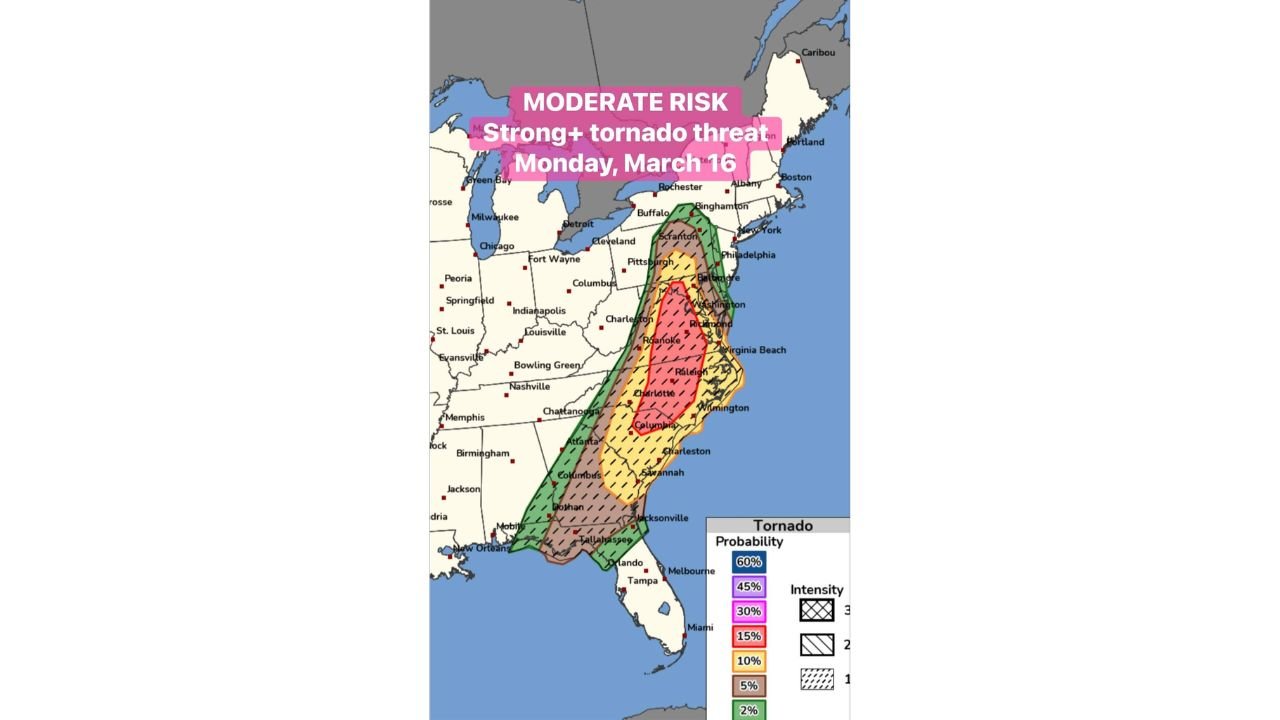
NORTH CAROLINA — A significant severe weather setup is expected to unfold Monday, March 16, 2026, across the eastern United States, with a Moderate Risk for severe storms stretching from the Carolinas through Virginia and into Maryland and Washington DC. The storm system carries the potential for strong tornadoes, damaging winds, and large hail as it moves north through the region.
The moderate risk zone forms a long corridor from South Carolina and North Carolina through Virginia and into southeastern Pennsylvania, placing several major cities within an area where severe storms may intensify during the day.
Moderate Risk Area Extends Across the Carolinas Into the Mid-Atlantic
Storm outlook maps show the highest concentration of severe weather risk centered across central North Carolina, including cities such as Charlotte, Raleigh, Durham, Greensboro, and Fayetteville.
The moderate risk zone then continues northward into Virginia, covering areas including Roanoke, Richmond, and Norfolk, before extending farther into Maryland and the Washington DC metro area.
Additional surrounding regions, including South Carolina, Georgia, and southeastern Pennsylvania, fall within broader severe storm risk zones where thunderstorms may also develop.
Tornado Potential Includes Possibility of Strong Tornadoes
Probability outlooks highlight a 15 percent tornado risk area with a hatched zone, indicating the potential for strong tornadoes within the broader severe weather corridor.
This higher tornado potential stretches from central North Carolina through southern and eastern Virginia, including areas near Raleigh, Richmond, and Virginia Beach.
Within this corridor, severe storms could organize into rotating thunderstorms capable of producing multiple tornadoes as the system moves northeast through the afternoon and evening hours.
Major Cities in the Storm Corridor
Several heavily populated areas lie within the projected severe weather path Monday, including:
- Charlotte, North Carolina
- Raleigh and Durham, North Carolina
- Richmond and Norfolk, Virginia
- Washington DC and surrounding Maryland suburbs
Communities along the Interstate 95 corridor could experience severe storms as the system tracks north through the Carolinas and into the Mid-Atlantic region.
Severe Weather Risk Extends From the Southeast to the Northeast
While the highest tornado potential focuses on the Carolinas and Virginia, the broader severe weather zone stretches much farther south and north.
Storm risk areas extend from northern Florida and southern Georgia through the Carolinas and into parts of Pennsylvania and New York, indicating the wide geographic reach of the developing storm system.
The most intense storm activity is expected within the central portion of this corridor, where atmospheric conditions appear most favorable for tornado development.
Storms Expected to Develop During the Day Monday
The severe weather event is expected to develop during the daytime hours Monday and continue into the evening, as storms move from the Southeast toward the Mid-Atlantic.
As the system tracks northward, communities across the Carolinas, Virginia, Maryland, and Washington DC may experience rapidly changing weather conditions including strong thunderstorms capable of producing tornadoes.
Residents across these areas should continue monitoring weather conditions as the storm system approaches.
Stay with CabarrusWeekly.com for continuing updates as severe weather develops across North Carolina and the Mid-Atlantic region.