North Carolina, Virginia, Maryland and Washington DC Face Rare Level 4 Severe Storm Risk Monday With Tornadoes and Damaging Winds Expected
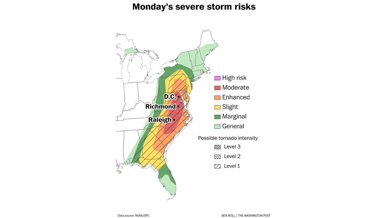
NORTH CAROLINA — A significant severe weather event is expected Monday across the eastern United States, with a Level 4 Moderate Risk for severe storms stretching from the Carolinas into Virginia, Maryland, and Washington DC. The storm system could bring tornadoes, damaging winds, and large hail as it moves north along the East Coast.
The risk corridor runs from South Carolina through North Carolina and Virginia into Maryland and southeastern Pennsylvania, placing several major population centers within an area where severe thunderstorms may intensify Monday afternoon and evening.
Moderate Risk Zone Centers on North Carolina and Virginia
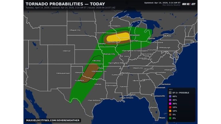
Storm outlook maps show the core of the moderate risk area across central North Carolina, including cities such as Charlotte, Raleigh, Durham, and Greensboro.
From there, the severe weather corridor extends north into Virginia, covering cities including Richmond and Norfolk, before reaching Maryland and Washington DC.
Surrounding areas across South Carolina, Georgia, and parts of Pennsylvania fall within broader severe storm risk zones where thunderstorms may still produce damaging weather.
Tornado Threat Extends From the Carolinas to the Mid-Atlantic
The severe weather outlook highlights a corridor where tornado development is possible from South Carolina into Maryland, with the highest concentration of potential storms across North Carolina and Virginia.
Cities including Raleigh, Richmond, and Washington DC fall within the zone where storms could rotate and produce tornadoes as they move northeast through the region.
Some of the storms may become strong, especially within the central portion of the risk corridor where atmospheric conditions appear most favorable for rotating thunderstorms.
Major Population Centers Within the Severe Storm Path
The projected storm path includes several large metropolitan areas across the Southeast and Mid-Atlantic.
Cities that may experience severe thunderstorms Monday include:
- Charlotte, Raleigh, and Greensboro, North Carolina
- Richmond and Norfolk, Virginia
- Baltimore, Maryland
- Washington DC
With millions of residents located along this corridor, the storm system could create disruptions to travel, power infrastructure, and daily activities.
Severe Storms Expected Monday Afternoon and Evening
The severe weather threat is expected to increase during the afternoon and evening hours Monday as the storm system moves from the Southeast toward the Mid-Atlantic region.
As storms move northeast, communities across the Carolinas, Virginia, Maryland, and Washington DC may experience rapidly changing weather conditions including strong thunderstorms capable of producing tornadoes.
For Washington DC, this storm setup marks one of the rare times the city has been placed under a Level 4 severe storm risk in recent years, highlighting the unusual nature of the forecast.
Stay with CabarrusWeekly.com for continuing updates as severe weather develops across North Carolina and the Mid-Atlantic region.