Michigan Upper Peninsula Blizzard Intensifies as Lake Effect Snow Brings Another 24 Hours of Heavy Snow and Dangerous Travel
MICHIGAN — A powerful winter storm continues to impact the Great Lakes region early Monday morning, with blizzard conditions and heavy lake-effect snow still ongoing across Michigan’s Upper Peninsula and parts of the northern Lower Peninsula.
Meteorologists report that while the earlier severe thunderstorm threat associated with the system has ended, the winter side of the storm remains active, bringing additional snowfall that could last through Tuesday morning. Some areas in the Upper Peninsula have already recorded more than two feet of snow, and forecasters say additional accumulation is likely as cold air continues to feed lake-effect snow bands across the region.
Upper Peninsula Remains Under Heavy Snow Bands
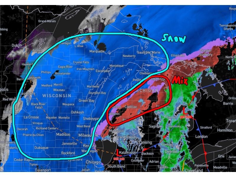
Radar imagery shows a widespread area of snow covering Michigan’s Upper Peninsula, including communities such as:
- Marquette
- Escanaba
- Manistique
- Iron Mountain
- Crystal Falls
- Sault Ste. Marie
These areas remain firmly within the core snow zone where steady snowfall and blowing snow continue to reduce visibility and make travel difficult. Lake-effect snow driven by cold air moving over the relatively warm waters of Lake Superior and Lake Michigan is helping intensify snowfall across the region.
Snow Expanding Across Northern Wisconsin
The snow shield also stretches west into northern Wisconsin, affecting cities including:
- Rhinelander
- Phillips
- Medford
- Wausau
- Eagle River
Much of northern Wisconsin is seeing steady snow as the storm system circulates around the Great Lakes, though conditions are expected to be most severe farther north in Michigan’s Upper Peninsula.
Mixed Precipitation in Northern Lower Michigan
While the Upper Peninsula experiences heavy snow, parts of north-central Lower Michigan are dealing with a mix of precipitation, including snow, sleet, and freezing rain.
Areas near Cadillac, Traverse City, and Rogers City remain within a transition zone where precipitation types vary depending on local temperatures. Forecasters expect this mixed precipitation area to gradually transition to all snow later Monday as colder air spreads south across the state.
Lake Effect Snow Expected to Strengthen Later Today
As colder air wraps around the backside of the storm system, meteorologists expect the lake-effect snow machine to intensify, potentially increasing snowfall rates later Monday and into the evening.
This process occurs when cold air moves over the Great Lakes, picking up moisture and producing localized snow bands that can dump large amounts of snow over specific areas. Communities downwind of Lake Superior and Lake Michigan may experience periods of heavy snow and blowing snow that significantly reduce visibility.
Dangerous Travel Conditions Expected
Officials are warning drivers across northern Michigan and Wisconsin to use caution due to snow-covered roads and areas of reduced visibility. Blowing snow may also make daytime driving hazardous in some locations, prompting officials to remind drivers to keep headlights and taillights on even during daylight hours.
With snow expected to continue for another day in parts of Michigan, road conditions may remain challenging through Tuesday morning. Stay with CabarrusWeekly.com for continuing national weather updates as major storms develop across the United States.