Colorado’s Denver and Front Range Swing From Near 90°F Heat to Sudden Cooldown as Dry Air, Wind, and Fire Danger Dominate Weekend Forecast
COLORADO — A dramatic and highly variable weather pattern is unfolding across Denver and the Front Range, where summer-like heat, dry air, and gusty winds are driving elevated fire danger before a sharp cooldown arrives Sunday.
Summer-Like Heat Builds Across Denver and the Front Range
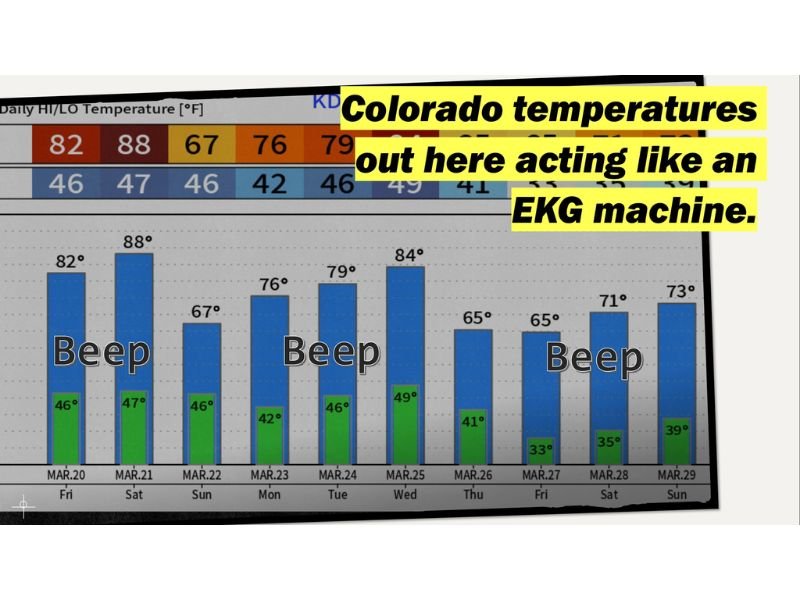
Temperature trends show daytime highs climbing well into the 80s through Saturday, with some locations approaching the 90-degree mark, an unusually warm setup for this time of year.
This warming is being driven by a dominant high-pressure system that is suppressing cloud development and allowing full sunshine to rapidly heat the region. Despite the warmth, overnight lows are still dropping into the 40s, creating large day-to-night temperature swings.
Dry Air and Wind Create Elevated Fire Risk
The combination of very dry air and periodic gusty winds, especially near the foothills and along the Divide, is creating heightened fire weather concerns across the Front Range.
Downslope winds coming off the mountains are enhancing drying conditions, leading to low humidity levels and an increased risk for rapid fire spread. Even brief wind gusts can significantly worsen fire behavior under these conditions.
No Meaningful Moisture in Sight
Precipitation chances remain extremely limited through the short-term forecast. The atmosphere is largely devoid of moisture, meaning skies will stay mostly clear and conditions will remain dry.
This ongoing dryness is contributing not only to fire danger but also to persistent moisture deficits across the region, with soils and vegetation continuing to dry out.
Temperature Swings Continue Through the Weekend
Forecast data highlights how variable temperatures will be over the coming days. Highs fluctuate from the low 80s to upper 80s, while overnight lows range from the low 40s down into the 30s later in the period.
This pattern reflects a classic Front Range setup where strong daytime heating is followed by rapid nighttime cooling, especially under clear skies.
Cold Front Brings Relief on Sunday
Relief arrives Sunday as a cold front pushes through the region. High temperatures are expected to drop into the low 60s, marking a noticeable cooldown compared to the preceding days.
Along with cooler air, residents can expect increasing winds and some cloud cover, with only a slight chance of light precipitation. While not a major storm system, it will bring a temporary break from the heat.
What Residents Should Expect
Through Saturday, residents should prepare for warm, dry, and occasionally windy conditions, especially during the afternoon when fire risk peaks.
By Sunday, the shift to cooler temperatures will be noticeable, but windy conditions may persist, continuing to pose some concerns despite the drop in temperatures.
Final Outlook
This stretch of weather highlights the volatility of early spring in Colorado, with near-record warmth, dry air, and fire danger quickly giving way to a cooler pattern.
While the cooldown will offer some relief, the lack of meaningful moisture means dry conditions will likely continue to be a concern beyond the weekend. Stay updated with CabarrusWeekly.com for the latest forecasts, and share how these rapid weather changes are affecting your area.